Shire of Broomehill
| Shire of Broomehill Western Australia | |||||||||||||
|---|---|---|---|---|---|---|---|---|---|---|---|---|---|
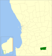 Location in Western Australia | |||||||||||||
| Population | 478 (2006)[1] | ||||||||||||
| • Density | 0.4076/km2 (1.0556/sq mi) | ||||||||||||
| Established | 1892 | ||||||||||||
| Area | 1,172.8 km2 (452.8 sq mi) | ||||||||||||
| Council seat | Broomehill | ||||||||||||
| Region | Great Southern | ||||||||||||
| |||||||||||||
The Shire of Broomehill was a local government area in the Great Southern region of Western Australia, about 20 kilometres (12 mi) south of Katanning and about 310 kilometres (193 mi) south-southeast of the state capital, Perth. The Shire covered an area of 1,173 square kilometres (453 sq mi), and its seat of government was the town of Broomehill.
The Broomehill Road Board was gazetted in 1892. On 1 July 1961, it became a shire following changes to the Local Government Act.[2] On 1 July 2008, after ten months of planning and preparation, it merged with the neighbouring Shire of Broomehill to form the Shire of Broomehill-Tambellup.
Wards
The shire was originally divided into wards, but as at 2007, it was a single electorate with eight representative councillors.
Towns and localities
- Broomehill
- Peringillup
References
- ↑ Australian Bureau of Statistics (25 October 2007). "Broomehill (S) (Local Government Area)". 2006 Census QuickStats. Retrieved 30 April 2014.
- ↑ WA Electoral Commission, Municipality Boundary Amendments Register (release 2.0), 31 May 2003.
Coordinates: 33°50′42″S 117°38′02″E / 33.845°S 117.634°E