Shire of Diamond Valley
| Shire of Diamond Valley Victoria | |||||||||||||
|---|---|---|---|---|---|---|---|---|---|---|---|---|---|
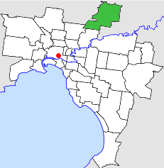 Location in Melbourne | |||||||||||||
| Population | 64,400 (1992)[1] | ||||||||||||
| • Density | 865.8/km2 (2,242.5/sq mi) | ||||||||||||
| Established | 1964 | ||||||||||||
| Area | 74.38 km2 (28.7 sq mi) | ||||||||||||
| Council seat | Greensborough | ||||||||||||
| Region | Melbourne | ||||||||||||
| County | Evelyn, Bourke | ||||||||||||
 | |||||||||||||
The Shire of Diamond Valley was a local government area about 20 kilometres (12 mi) northeast of Melbourne, the state capital of Victoria, Australia. The shire covered an area of 74.38 square kilometres (28.72 sq mi), and existed from 1964 until 1994.
History
The name relates to the lowlands to the west of Diamond Creek, a tributary of the Yarra River, which flows through nearby Eltham.
Land in the area was first incorporated as part of the Heidelberg Road District on 12 October 1860, which became a shire on 27 March 1864 and was proclaimed as the City of Heidelberg on 11 April 1934.[2] On 30 September 1964, the North Ward of the City of Heidelberg was severed, and incorporated as the Shire of Diamond Valley.[2]
On 15 December 1994, the Shire of Diamond Valley was abolished; areas south of the Metropolitan Ring Road and the Greensborough Highway were transferred to the newly created City of Banyule, while areas north were merged with most of the Shire of Eltham and parts of the City of Whittlesea, into the newly created Shire of Nillumbik. A small area in the shire's southwest, north of La Trobe University, including Gresswell Forest Nature Reserve, was transferred to the City of Darebin.[3]
Council met at the Diamond Valley Civic Centre, in Civic Circuit, Greensborough. The facility is still used by the Shire of Nillumbik.
Wards
The Shire of Diamond Valley was divided into four ridings, each of which elected three councillors:
- South West Riding
- South East Riding
- Centre Riding
- North Riding
Suburbs
- Briar Hill (shared with the Shire of Eltham)
- Bundoora (shared with the Cities of Preston and Whittlesea)
- Diamond Creek
- Eltham North
- Greensborough
- Hurstbridge (shared with the City of Whittlesea and Shire of Eltham)
- Macleod (shared with the City of Heidelberg)
- Plenty
- St Helena
- Watsonia
- Watsonia North
- Wattle Glen (shared with the Shire of Eltham)
- Yarrambat
Population
| Year | Population |
|---|---|
| 1961 | 15,631# |
| 1966 | 22,993 |
| 1971 | 36,245 |
| 1976 | 45,461 |
| 1981 | 50,503 |
| 1986 | 55,122 |
| 1991 | 60,738 |
* Estimate in the 1958 Victorian Year Book.
# The Shire of Diamond Valley was created in 1964. Source of population: 1968 Victorian Year Book.
References
- ↑ Australian Bureau of Statistics, Victoria Office (1994). Victorian Year Book. p. 49. ISSN 0067-1223.
- 1 2 Victorian Municipal Directory. Brunswick: Arnall & Jackson. 1992. pp. 397–398, 652–653. Accessed at State Library of Victoria, La Trobe Reading Room.
- ↑ Australian Bureau of Statistics (1 August 1995). Victorian local government amalgamations 1994-1995: Changes to the Australian Standard Geographical Classification (PDF). Commonwealth of Australia. pp. 4–5, 10. ISBN 0-642-23117-6. Retrieved 2007-12-16.
Coordinates: 37°41′S 145°07′E / 37.683°S 145.117°E