Shrewsbury, West Virginia
| Shrewsbury, West Virginia | |
|---|---|
| Census-designated place (CDP) | |
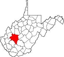
 Location in Kanawha County and state of West Virginia. | |
| Coordinates: 38°12′22″N 81°28′17″W / 38.20611°N 81.47139°WCoordinates: 38°12′22″N 81°28′17″W / 38.20611°N 81.47139°W | |
| Country | United States |
| State | West Virginia |
| County | Kanawha |
| Area[1] | |
| • Total | 0.435 sq mi (1.13 km2) |
| • Land | 0.350 sq mi (0.91 km2) |
| • Water | 0.085 sq mi (0.22 km2) |
| Elevation | 623 ft (190 m) |
| Population (2010)[2] | |
| • Total | 652 |
| • Density | 1,500/sq mi (580/km2) |
| Time zone | Eastern (EST) (UTC-5) |
| • Summer (DST) | EDT (UTC-4) |
| Area code(s) | 304 & 681 |
| GNIS feature ID | 1546745[3] |
Shrewsbury is a census-designated place (CDP) in Kanawha County, West Virginia, United States. Shrewsbury is located on the north bank of the Kanawha River along U.S. Route 60. As of the 2010 census, its population was 652.[2]
References
- ↑ "US Gazetteer files: 2010, 2000, and 1990". United States Census Bureau. 2011-02-12. Retrieved 2011-04-23.
- 1 2 "American FactFinder". United States Census Bureau. Retrieved 2011-05-14.
- ↑ U.S. Geological Survey Geographic Names Information System: Shrewsbury, West Virginia
This article is issued from Wikipedia - version of the 7/31/2014. The text is available under the Creative Commons Attribution/Share Alike but additional terms may apply for the media files.