Sicignano degli Alburni
| Sicignano degli Alburni | ||
|---|---|---|
| Comune | ||
| Comune di Sicignano degli Alburni | ||
|
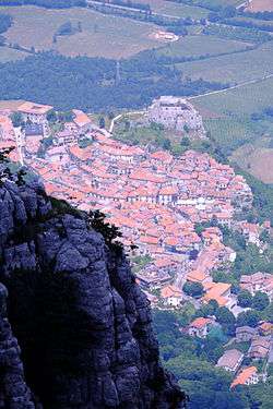
View with the castle | ||
| ||
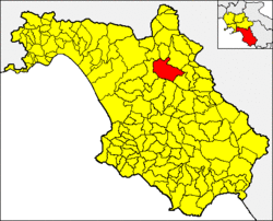 Sicignano degli Alburni within the Province of Salerno | ||
 Sicignano degli Alburni Location of Sicignano degli Alburni in Italy | ||
| Coordinates: 40°33′34.8″N 15°18′25.2″E / 40.559667°N 15.307000°ECoordinates: 40°33′34.8″N 15°18′25.2″E / 40.559667°N 15.307000°E | ||
| Country | Italy | |
| Region | Campania | |
| Province / Metropolitan city | Salerno (SA) | |
| Frazioni | Castelluccio Cosentino, Galdo degli Alburni, Scorzo, Terranova, Zuppino | |
| Government | ||
| • Mayor | Alfonso Amato | |
| Area | ||
| • Total | 80.57 km2 (31.11 sq mi) | |
| Elevation | 605 m (1,985 ft) | |
| Population (2010-12-31)[1] | ||
| • Total | 3,311 | |
| • Density | 41/km2 (110/sq mi) | |
| Demonym(s) | Sicignanesi | |
| Time zone | CET (UTC+1) | |
| • Summer (DST) | CEST (UTC+2) | |
| Postal code | 84029 | |
| Dialing code | 0828 | |
| Patron saint | St. Matthew | |
| Saint day | 7 April | |
| Website | Official website | |
Sicignano degli Alburni (also known simply as Sicignano) is a town and comune in the province of Salerno in the Campania region of southern Italy. As of 2010 its population was of 3,311.[1]
History
The Roman war hero Lucio Siccio Dentato, or Lucius Sicinius Dentatus, of the gens Sicinia founded Sicignano degli Alburni as his ancient latifundium.
The earliest documentation of Sicignano is from a medieval donation document dated 1086 of the norman count Asclettino Sicignano, Lord of Polla († 1086), gives the abbey of Cava dei Tirreni the monastery of St. Peter and St. Catherine's Church, located in the Castrum Pollae.
From 1811 to 1860, Sicignano was part of the district of Postiglione, belonging to the District of Country of the Two Sicilies.
From 1860 to 1927, during the Kingdom of Italy it was part of the district of Postiglione, belonging to the district to campaign.
Geography
Overview
Sicignano is located between the valley of the Tanagro river and the Alburni mountain range; its territory lying mostly within the Parco nazionale del Cilento e Vallo di Diano.
The municipality is bordered by Auletta, Buccino, Castelcivita, Contursi Terme, Ottati, Palomonte, Petina and Postiglione.
Frazioni
Sicignano has got 5 civil parishes (frazioni):
| Village | Population | Coordinates |
|---|---|---|
| Castelluccio Cosentino | 250 |
|
| Galdo degli Alburni | 300 |
|
| Scorzo | 800 |
|
| Terranova | 200 |
|
| Zuppino | 700 |
The municipality includes also several inhabited localities, mainly composed by few scattered farms. The localities are: Acquara, Acqua della Battaglia, Acqua Salice, Arestusa, Bauso, Buonocanto, Casale, Cerzolle, Colasoria, Corticelle, Cropana, Galdo Scalo, Giungarico, Padula, Padule, Patricella,[2] Pellicara, Piesco, Rotale, Sant'Arsenio, Santa Croce, San Giovanni, San Licandro (Sicignano Scalo), Taverna Castello, Tempa delle Ginestre, Tempe, Varamanna and Vignali.
Photogallery
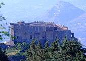 The Castle of Sicignano degli Alburni
.jpg) The medieval castle of Sicignano (top) and the hamlet of Galdo
The medieval castle of Sicignano (top) and the hamlet of Galdo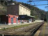 Sicignano railway station, located in San Licandro
.JPG) The valley of Sicignano
The valley of Sicignano Alburni and the Tanagro valley
See also
References
External links
| Wikimedia Commons has media related to Sicignano degli Alburni. |
- (Italian) Sicignano degli Alburni official website
- (Italian) Sicignano degli Alburni on paesionline.it
- (English) The Sicignano Family