Sion Airport
| Sion Airport Aéroport de Sion | |||||||||||||||
|---|---|---|---|---|---|---|---|---|---|---|---|---|---|---|---|
 | |||||||||||||||
| IATA: SIR – ICAO: LSGS / LSMS | |||||||||||||||
| Summary | |||||||||||||||
| Serves | Sion, Switzerland | ||||||||||||||
| Location | Sion | ||||||||||||||
| Elevation AMSL | 483 m / 1,585 ft | ||||||||||||||
| Coordinates | 46°13′10.53″N 7°19′36.35″E / 46.2195917°N 7.3267639°E | ||||||||||||||
| Website | sionairport.ch | ||||||||||||||
| Map | |||||||||||||||
 SIR Location of airport in Switzerland | |||||||||||||||
| Runways | |||||||||||||||
| |||||||||||||||
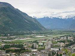
Sion Airport (IATA: SIR, ICAO: LSGS) (Military: LSMS) is the airport of the city of Sion, Switzerland[1] and is located 2.5 km southwest of Sion city in the Rhone Valley.[2] The airport opened in 1935.[3]
Airlines and destinations
The following airlines offer regular scheduled and charter flights at Sion Airport:[4]
| Airlines | Destinations |
|---|---|
| Air Glaciers | Seasonal: Calvi, Elba, Figari, La Môle/Saint-Tropez |
| Helvetic Airways | Seasonal charter: Palma de Mallorca (begins 23 April 2017) |
| Swiss International Air Lines operated by Helvetic Airways | London-Heathrow (begins 4 February 2017; ends 25 February 2017),[5] Zürich (begins 4 February 2017; ends 25 February 2017)[6] |
The nearest larger international airport is Geneva Airport, approx. 110 kilometres (68 mi) to the west.
Military usage
The Swiss Air Force uses Sion as one of their four jetfighter air bases, the others being Payerne, Meiringen and Emmen. It is known as Flugplatzkommando 14 Sion. In addition to the prop-types Pilatus PC-6, Pilatus PC-7, Pilatus PC-9 and Pilatus PC-21 as well as helicopters it uses Sion intensively with the fighter jets F/A-18 and F-5 Tiger. It is the home base of the militia pilot sqd., Sqd.19 Swans with F-5E and Sqd.16 Dragons with F-5F. Sion Airport is, at both ends of the runway, equipped with retractable arresting gear devices (used by the F/A-18 and in case of a problem by the F-5).
Because of the redimension of the Swiss Air Force it is planned that the Air Force will leave Sion after 2016 and Sion will be used by civil aviation only.
See also
References
External links
![]() Media related to Sion Airport at Wikimedia Commons
Media related to Sion Airport at Wikimedia Commons