Sirpur
| Sirpur Town సిర్పూర్ పట్టణం | |
|---|---|
| Village | |
|
Sirpur Town Fort | |
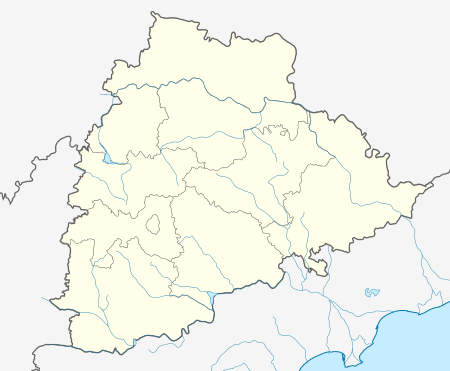 Sirpur Town Location in Telangana, India | |
| Coordinates: 19°29′00″N 79°36′00″E / 19.4833°N 79.6000°ECoordinates: 19°29′00″N 79°36′00″E / 19.4833°N 79.6000°E | |
| Country | India |
| State | Telangana |
| District | Adilabad |
| Mandal | Sirpur (T) |
| Government | |
| • Type | Gram Panchayat |
| • Body | Sirpur Town Major Gram Panchayat |
| Area[1] | |
| • Total | 8.88 km2 (3.43 sq mi) |
| Elevation | 184 m (604 ft) |
| Population (2011) | |
| • Total | 9,183 |
| • Density | 1,000/km2 (2,700/sq mi) |
| Languages | |
| • Official | Telugu, English |
| • Others | Urdu, Marathi |
| Time zone | IST (UTC+5:30) |
| PIN | 504299 |
| Telephone code | 08738 |
| Vehicle registration | TS 01 |
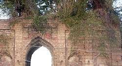
Sirpur Town is a village in east part of Adilabad district of the Indian state of Telangana. It is located in Sirpur (T) mandal of Asifabad revenue division.[2] Sirpur-T is a village and a Mandal in Adilabad district,It is notable for Sirpur paper mills.It rests on the banks of river Wardha. Sirpur is around 160 km west of Adilabad city. Sirpur, formerly known as Suryapuram, was ruled by the Gond King, Ballala. Sipurt Fort is a major tourist attraction,The Gond King, Bhim Ballal Sing built Sirpur Fort in 9th century AD. The modern town grew around the fort. Distinction of the town is the Sirpur Paper Mills, one of the biggest paper mills in India and hence the name Sirpur Kagaznagar.Hyderabad Airport is the nearest airport.Sirpur Town Railway Station and Sirpur Kagaznagar Railway Station serve the town.
History
In 1724 AD Nizam-e-Mulk defeated Mubariz Khan and took possession of the Deccan and began to rule. In 1773 Madhoji Bhonsle entered into an agreement with Nizam Ali Khan, Nizam of Hyderabad by which he agreed to cede Manikgarh (Rajura of Chandrapur) with surrounding territories south of Penganga to the Nizam, in return for the forts of Gavilgarh and Narnala of Amaravati district - Berar. As a result of war between the British and Raghoji Bhonsale II, the latter ceded the territory of Berar to British who, in turn passed it on to Nizam under treaty and obligation for cooperation in war. Consequently, Sirpur the ancient seat of Gond Rajas passed into the hands of Asaf Jahi rulers. The area was initially a sub district called Sirpur-Tandur carved out in 1872 and comprised Edlabad (Adilabad), Rajura (now in Maharashtra) and Sirpur taluks. Sirpur-Tandur was originally a district in Maratwada region.
The district, named after Ali Adil Shah, ruler of Bijapur, was conferred its present status in 1905 with Adilabad town as its headquarters. Sirpur is the perfect boundary for Andhra Pradesh(now Telangana) while going towards Delhi.
Geography
Sirpur Town is located at 19.4833°N 79.6000°E [3] It has an average elevation of 184 meters (603.675 feet).It rests on the banks of river Wardha
Climate
All the three seasons are extreme in this region. Summer is extremely hot with temperatures exceeding 46 degrees due to the presence of Singareni Collieries nearby. December is usually the coldest month in this place with the temperature varying from 10 to 30 degrees Celsius
Education
list of schools in sirpur town
- Government Junior College
- Zilla Parishath High School
- AP Social Welfare Residential School and Junior College
- APSWR SCHOOL Girls DPI
- GOVT.ASHRAM GIRLS School
- GOVT. TRIBAL ASHRAMA HIGH School
- Eden Garden English Medium School
- SRI SAI VIDYA MANDIR
- MPP school,Dubbaguda
- MPUP school,SIrpur Town
Culture
Festivals
Pola
Pola is major festival celebrated by formers mainly in Telangana, people who share the border with Maharashtra, Pola is a bull-worshipping festival celebrated by farmers mainly in the Indian state of Maharashtra,Telangana. On the day of Pola, the farmers decorate and worship their bulls. Pola falls on the day of the Pithori Amavasya (the new moon day) in the month of Shravana (usually in August).Pola is the main festival of the farmers of the Maharashtra, especially the Kunbis.[2] Puran Poli, karanji, and curry with five vegetables are the main dishes associated with the festival.
Temples
- Sri Venkateshwara Temple
- Sri Siddi Tonkini Hanuman Temple
- Sri Shirdi Sai Baba Temple,Navegon
Sirpur Assembly constituency
Sirpur is an assembly constituency in Telangana.
List of Elected Members:[3]
- 1978 - K.V. Keshavulu
- 1983 and 1989 - K.V. Narayana Rao
- 1989 and 1999 - Palvai Purushotham Rao
- 1999 - Palvai Rajyalaxmi
- 2004 - Koneru Konappa
- 2009 - Kaveti Sammaih
- 2010 - Kaveti Sammaih
- 2014 to present - Koneru Konappa
Transport
Road
Sirpur town is well connected by road from major parts of Telangana via kaghaznagar.Telangana State run TSRTC buses runs to various towns.It is well connected with Chandrapur and Gondpipari and most of surrounding towns in Maharastra.
Railways
The railway station is last railway station between the border of Maharashtra and Telangana.Sirpur Town railway station is located on Nagpur-Kazipet-Secunderabad-route at a distance of 18 kilometres from Sirpurkaghaznagr railway station . It is administrated by South Central Railway zone. There is only one trains that directly connects Hyderabad starting from Balharshah namely Bhagyanagr Express.
Sirpur Town railway station trains list
- Bhagyanagr Express
- Singareni passenger
- Ramagiri Passenger
- Kazipet-Ajni Passenger
- Pushpull Passenger
Localities
- Bus stand Area
- Downhall
- Petmahela
- Railway colony
- New Colony
- Brahman Wada
- Govindpur
- Dubbaguda
Places of interest
- Sirpur Balaji Temple
- Sai Baba Temple
- Sri Siddi Tonkini Hanuman Temple
- Sri Shirdi Sai Baba Temple,Navegon
- Talib Ali Shah Dargah
- Hudkuli Irrigation Project
References
- ↑ "District Census Handbook - Adilabad" (PDF). Census of India. p. 256. Retrieved 20 November 2015.
- ↑ "District Level Mandal wise List of Villages in Andhra Pradesh" (PDF). Chief Commissioner of Land Administration. National Informatics Centre. pp. 16–17. Archived from the original (PDF) on 20 November 2015. Retrieved 20 November 2015.
- ↑ Election Commission of India. APAssembly results.1978-2004