Skoteini
| Skoteini Σκοτεινή | |
|---|---|
 | |
 Skoteini | |
| Coordinates: 37°47′N 22°26′E / 37.783°N 22.433°ECoordinates: 37°47′N 22°26′E / 37.783°N 22.433°E | |
| Country | Greece |
| Administrative region | Peloponnese |
| Regional unit | Argolis |
| Municipality | Argos-Mykines |
| Municipal unit | Alea |
| Elevation | 690 m (2,260 ft) |
| Community[1] | |
| • Population | 347 (2011) |
| Time zone | EET (UTC+2) |
| • Summer (DST) | EEST (UTC+3) |
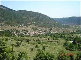
Skoteini (Greek: Σκοτεινή) is a small mountain village 57 kilometres southwest of the town of Argos in the Peloponnese, southern Greece. It has an area of 44 km² and sits at an altitude of 690 meters above sea level. Its name derives from the Greek word for "darkness".
According to the 2011 census, the population of Skoteini was 347, a drop from the 1981 census, when the town was inhabited by 412 people.
- "Driving through the plain of Alea, you reach the village of Skoteini, one of the most beautiful landscapes of Argolida County. It holds a key post, as it is a passage of all three counties (Argolida, Arcadia, and Corinthia). Skoteini was gradually built in three locations and it is now situated upon two mountainsides. Skoteini has always been a large village. It contains many new houses, cafes, bars, an elementary school and a high school. It is a lively and modern mountainous village that has adopted the new way of living. The locals deal with cultivation."[2]
References
- ↑ "Απογραφή Πληθυσμού - Κατοικιών 2011. ΜΟΝΙΜΟΣ Πληθυσμός" (in Greek). Hellenic Statistical Authority.
- ↑ Extract from the Prefecture of Argolis tourist pamphlet, April 2004.
This article is issued from Wikipedia - version of the 10/13/2016. The text is available under the Creative Commons Attribution/Share Alike but additional terms may apply for the media files.