Slidell Airport
| Slidell Airport | |||||||||||
|---|---|---|---|---|---|---|---|---|---|---|---|
| IATA: none – ICAO: KASD – FAA LID: ASD | |||||||||||
| Summary | |||||||||||
| Airport type | Public | ||||||||||
| Owner | City of Slidell | ||||||||||
| Serves | Slidell, Louisiana | ||||||||||
| Elevation AMSL | 29 ft / 9 m | ||||||||||
| Coordinates | 30°20′47″N 089°49′15″W / 30.34639°N 89.82083°W | ||||||||||
| Runways | |||||||||||
| |||||||||||
| Statistics (2008) | |||||||||||
| |||||||||||
Slidell Airport (ICAO: KASD, FAA LID: ASD) is a city-owned public-use airport located four nautical miles (7 km) northwest of the central business district of Slidell, a city in St. Tammany Parish, Louisiana, United States.[1]
Although most U.S. airports use the same three-letter location identifier for the FAA and IATA, this airport is assigned ASD by the FAA but has no designation from the IATA[2] (which assigned ASD to Andros Town Airport on Andros Island in the Bahamas[3]).
Facilities and aircraft
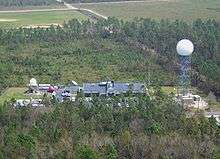
Slidell Airport covers an area of 340 acres (140 ha) at an elevation of 29 feet (9 m) above mean sea level. It has one runway designated 18/36 with a 5,001 by 100 ft (1,524 x 30 m) asphalt surface.[1] The Louisiana Office of the National Weather Service is colocated.
For the 12-month period ending April 15, 2008, the airport had 112,000 aircraft operations, an average of 306 per day: 96% general aviation, 4% military. At that time there were 86 aircraft based at this airport: 87% single-engine, 9% multi-engine, 2% helicopter and 1% jet.[1]
References
- 1 2 3 4 FAA Airport Master Record for ASD (Form 5010 PDF), effective 2009-05-07.
- ↑ Great Circle Mapper: KASD - Slidell, Louisiana
- ↑ Great Circle Mapper: ASD / MYAF - Andros Town, Bahamas
External links
- FAA Terminal Procedures for ASD, effective December 8, 2016
- Resources for this airport:
- FAA airport information for ASD
- AirNav airport information for KASD
- FlightAware airport information and live flight tracker
- NOAA/NWS latest weather observations
- SkyVector aeronautical chart, Terminal Procedures