Snake Island (Black Sea)
| Native name: <span class="nickname" ">Insula Serpilor | |
|---|---|
 Snake Island | |
| Geography | |
| Location | Black Sea |
| Coordinates | 45°15′N 30°12′E / 45.250°N 30.200°E |
| Area | 0.17 km2 (0.066 sq mi) |
| Length | 0.662 km (0.4113 mi) |
| Width | 0.440 km (0.2734 mi) |
| Highest elevation | 41 m (135 ft) |
| Highest point | N/An |
| Administration | |
|
Ukraine | |
| Demographics | |
| Population | Around 100 |
Coordinates: 45°15′18″N 30°12′15″E / 45.25500°N 30.20417°E Snake Island (Greek: "Fidonisi" - Φιδονήσι), also known as Serpent Island (Romanian: Insula Șerpilor, Ukrainian: Зміїний), is an island located in the Black Sea, near the Danube Delta.
The island is populated. A rural settlement of Bile was established in February 2007.
The islet was part of border dispute between Romania and Ukraine in 2004–2009, during which Romania contested technical definition of the island and borders around it. The territorial limits of the continental shelf around Snake Island were delineated by the International Court of Justice in 2009.[1]
Geography
Snake Island is an igneous rock formation located 35 km from the coast, east of the mouth of the Danube River. The island's coordinates are 45°15′18″N 30°12′15″E / 45.25500°N 30.20417°E. The island is X-shaped, 690 meters from S-W to N-E by 682 meters from N-W to S-E, covering an area of 0.205 km2. The highest area is 41 metres (135 ft) above sea level. The island does not have a prominently featured mountain, but rather a low-slope hill.
The nearest coastal location to the island is Kubanskyi Island on the Ukrainian part of the Danube Delta, located 35 km (22 mi) away between the Bystroe Channel and Skhidnyi Channel. The closest Romanian coastal city, Sulina, is 45 km (28 mi) away. The closest Ukrainian city is Vylkove, 50 km (31 mi); however, there also is a port Ust-Dunaisk, 44 km (27 mi) away from the island.
For the end of 2011 in Zmiinyi Island coastal waters 58 fish species (12 of which are included into the Red Book of Ukraine)[2] and six crab species were recorded. A presidential decree of 9 December 1998, Number 1341/98, declared the island and coastal waters as a state-protected area. The total protected area covers 232 hectares.
Population and infrastructure
.jpg)
About 100 inhabitants live on the island, mostly frontier guard servicemen with their families and technical personnel. In 2003, an initiative of the Odessa I. I. Mechnikov National University established the Ostriv Zmiinyi marine research station every year at which scientists and students from the university conduct research on local fauna, flora, geology, meteorology, atmospheric chemistry, and hydrobiology.
The island is currently demilitarized and under rapid development. In accordance with a 1997 Treaty between Romania and Ukraine, the Ukrainian authorities withdrew an army radio division, demolished a military radar, and transferred all other infrastructure to civilians. Eventually the Romania-Ukraine international relationships soured (see "Maritime delimitation" section) when Romania tried to assert that the island is no more than a rock in the sea. In February 2007, the Verkhovna Rada approved establishing a rural settlement as part of Vylkove city which is located some distance away at the mouth of the Danube. However, the island had been continually populated even before although not officially.
In addition to a helicopter platform, in 2002 a pier was built for ships with up to 8 meter draught, and construction of a harbor is underway. The island is supplied with navigation equipment, including a 150-year-old lighthouse. Electric power is provided by a dual solar/diesel power station. The island also has an adequately developed civil infrastructure such as the marine research station, a post office, a bank (branch of the Ukrainian bank "Aval"), the first-aid station, a satellite television provider, a phone network, a cell phone tower, and an Internet link. Most of building structures are located either in the middle of the island by a lighthouse or the northeastern peninsula of the island by its pier.
The island lacks a fresh water source.[3] Its border guard contingent is regularly resupplied by air.[4] Since 2009 the development of the island was suspended due to financing which caused a great degree of concern of local authorities asking for more funding from the state.[5]
Lighthouse
| Snake Island Lighthouse | |
|---|---|
| Mаяк | |
|
The lighthouse on the background in 1896. | |
| General information | |
| Type | service |
| Town or city | Bile (Vylkove) |
| Country | Ukraine |
| Elevation | 40 metres (130 ft) |
| Completed | autumn 1842 |
| Height | 12 metres (39 ft) |
| Design and construction | |
| Main contractor | Black Sea Fleet |
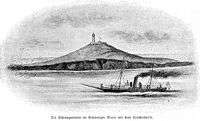
The Snake Island Lighthouse was built in the autumn of 1842[6] by the Black Sea Fleet of the Russian Empire. The lighthouse is an octahedral-shaped building, 12 meters tall, located near the highest elevated area of the island, 40 meters above the sea level. The lighthouse built on site of the previously destroyed temple of Achilles is adjacent to a housing building. The remnants of the Greek temple were found in 1823.
As lighthouse technology progressed, in 1860 new lighthouse lamps were bought from England, and one of them was installed in the Lighthouse in 1862. In the early 1890s a new kerosene lamp was installed, with lamp rotating equipment and flat lenses. It improved the lighthouse visibility to up to 20 miles (32 km).
The lighthouse was heavily damaged during World War II by Soviet aviation and German retreating forces. It was restored at the end of 1944 by the Odessa military radio detachment. In 1949 it was further reconstructed and equipped by the Black Sea Fleet. The lighthouse was further upgraded in 1975 and 1984. In 1988 a new radio beacon "KPM-300" was installed with radio signal range of 150 miles (240 km).
In August 2004, the lighthouse was equipped with a radio beacon "Yantar-2M-200", which provides differential correction signal for global navigation satellite systems GPS and GLONASS.
The lighthouse is listed as UKR 050 by ARLHS, EU-182 by IOTA, and BS-07 by UIA.
History
The island was named by the Greeks Leucos (Greek: Λευκός, "White Island") and was similarly known by Romans as Alba, probably because of the white marble formations that can be found on the isle. The uninhabited isle Achilleis ("of Achilles") was the major sanctuary of the Achaean hero, where "seabirds dipped their wings in water to sweep the temples clean" (Kyriazis). Several temples of Thracian Apollo can be found here, and there are submerged ruins.
According to an epitome of the lost Trojan War epic of Arctinus of Miletus, the remains of Achilles and Patroclus were brought to this island by Thetis, to be put in a sanctuary. Ruins believed to be of a square temple dedicated to Achilles, 30 meters to a side, were discovered by Captain Kritzikly in 1823. Ovid, who was banished to Tomis, mentions the island, so do Ptolemy and Strabo.[7] The island is described in Pliny the Elder's Natural History, IV.27.1.
Several ancient inscriptions were found on the island, including a 4th-century BC Olbiopolitan decree which praises someone for defeating and driving out the pirates that lived on the "holy island".
Modern history

The Greeks during the Ottoman Empire renamed it Fidonisi (Greek: Φιδονήσι, "Snake Island") and the island gave its name to the naval Battle of Fidonisi, fought between the Ottoman and Russian fleets in 1788, during the course of the Russo-Turkish War of 1787–1792.
In 1829, following the Russo–Turkish War of 1828-1829, the island became part of the Russian Empire until 1856.
In 1877, following the Russo-Turkish War of 1877–1878, the Ottoman Empire gave the island and Northern Dobrudzha region to Romania, as a reimbursement for the Russian annexation of Romania's southern Bessarabia region.
The Paris Peace Treaties of 1947 between the protagonists of World War II ceded Northern Bukovina, the Hertza region, Budjak, and Bessarabia to the USSR but made no mention of the mouths of the Danube and Ostriv Zmiinyi.
Until 1948, Snake Island was considered part of the Romanian coastal city of Sulina. In 1948, the Soviets forced the Romanian side (occupied by Soviet troops) to accept the "transfer" of Snake Island to the Soviet Union, as well as to accept to move the Romanian border in the Danube Delta towards the west, in favour of the USSR (resulting in the annexation of Limba Island by the USSR). Romania has strongly disputed the validity of this "treaty", since it was never ratified by either of the two countries, which would make the Limba Island and Snake Island de jure Romanian territory.
The same year, in 1948, during the Cold War, a Soviet radar post was built on the isle (for both naval and anti-aircraft purposes).
The Soviet Union's possession of Snake Island was confirmed in the Treaty between the Government of the People's Republic of Romania and the Government of the Union of the Soviet Socialist Republics on the Romanian-Soviet State Border Regime, Collaboration and Mutual Assistance on Border Matters, signed in Bucharest on February 27, 1961.
Between 1967 and 1987, the USSR and Romanian side were negotiating the delimitation of the continental shelf. The Romanian side refused to accept a Russian offer of 4000 km2 out of 6000 km2 around the island in 1987.
Following the collapse of the Soviet Union in 1991, Ukraine inherited control over the island. A number of Romanian parties and organizations consistently claimed it should be included in its territory. According to the Romanian side, in the peace treaties of 1918 and 1920 (after World War I), the isle was considered part of Romania, and it was not mentioned in the 1947 border-changing treaty between Romania and the Soviet Union.
In 1997, Romania and Ukraine signed a treaty in which both states "reaffirm that the existing border between them is inviolable and therefore, they shall refrain, now and in future, from any attempt against the border, as well as from any demand, or act of, seizure and usurpation of part or all the territory of the Contracting Party". However, both sides have agreed that if no resolution on maritime borders can be reached within two years, then either side can go to the International Court of Justice to seek a final ruling.
In 2008, twelve Ukrainian border guards died when their helicopter flying from Odessa to Snake Island crashed, killing all but one on board.[4]
Maritime delimitation
The status of Snake Island was important for delimitation of continental shelf and exclusive economic zones between the two countries. If Snake Island were recognized as an island, then continental shelf around it should be considered as Ukrainian water. If Snake Island were not an island, but a rock,[3] then in accordance with international law the maritime boundary between Romania and Ukraine should be drawn without taking into consideration the isle location.
On 4 July 2003 the President of Romania Ion Iliescu and the President of Russia Vladimir Putin signed a treaty about friendship and cooperation. Romania promised not to contest territories of Ukraine or Moldova, which it lost to Soviet Union after World War II, but requested that Russia as a successor of the Soviet Union recognized in some form its responsibility for what had happened.[8]
On 16 September 2004 the Romanian side brought a case against Ukraine to the International Court of Justice (ICJ) in a dispute concerning the maritime boundary between the two States in the Black Sea.[9]
On February 3, 2009, the ICJ delivered its judgment, which divided the sea area of the Black Sea along a line which was between the claims of each country. The Court invoked the disproportionality test in adjudicating the dispute, noting that the ICJ, "as its jurisprudence has indicated, it may on occasion decide not to take account of very small islands or decide not to give them their full potential entitlement to maritime zones, should such an approach have a disproportionate effect on the delimitation line under consideration" and owing to a previous agreement between Ukraine and Romania, the island "should have no effect on the delimitation in this case, other than that stemming from the role of the 12-nautical-mile arc of its territorial sea" previously agreed between the parties.[10]
See also
References and footnotes
- Inline:
- ↑ International Court of Justice: Maritime Delimitation in the Black Sea (Romania v. Ukraine)
- ↑ Snigirov S, Goncharov O, Sylantyev S. The fish community in Zmiinyi Island waters: structure and determinants. Marine Biodiversity 2012. doi:10.1007/s12526-012-0109-4
- 1 2 Ruxandra Ivan (2012). New Regionalism Or No Regionalism?: Emerging Regionalism in the Black Sea Area. Ashgate Publishing, Ltd. p. 167. ISBN 978-1-4094-2213-6.
- 1 2 Ukrainian helicopter crash kills 12, Reuters, Mar 27, 2008
- ↑ An appeal of the Odessa Regional Council to the Verkhovna Rada and the Cabinet of Ministers of Ukraine on the further development of infrastructure of the Snake Island and the Bile settlement of the Kiliya Raion of Odessa Oblast. November 9, 2012.
- ↑ Vitrenko's Odessa website (Russian)
- ↑ Geography, book II.5.22
- ↑ Russia and Romania: compromise on history. BBC Russia. 4 July 2003
- ↑ "Romania brings a case against Ukraine to the Court in a dispute concerning the maritime boundary between the two States in the Black Sea" (PDF). International Court of Justice. September 16, 2004.
- ↑ "The Court establishes the single maritime boundary delimiting the continental shelf and exclusive economic zones of Romania and Ukraine" (PDF). International Court of Justice. February 3, 2009.
- General:
- Korrespondent.net: December 2003 report on Snake Island dispute, including aerial picture of the isle (Russian)
- Korrespondent.net: Maritime Delimitation as of August 2005 (Russian)
- BBC Romanian report on the bank opening (Romanian)
- Aurelian Teodorescu, "Snake Island: Between rule of law and rule of force": The Ostriv Zmiinyi dispute from the Romanian perspective (Romanian)
- Constantine D. Kyriazis, Eternal Greece: Achilles' sanctuary
- Nicolae Densușianu, Dacia Preistorică, 1913, I.4; Literary references to the island in Antiquity
- Cotidianul: "OMV cauta petrol linga Insula Serpilor" (Romanian)
- Olexandr Fomin, The history of Snake Island Lighthouse, Zerkalo Nedeli, February 26, 2000. (Russian)
- Tetyana Silina, The Island of Achilles, Dzerkalo Tyzhnia, February 16, 2007. (Ukrainian)
- Civic Media, Ukraine and Romania in strategic war in the Black Sea, Civic Media, October, 2007. (Romanian)
- Civic Media, The natural right of Romania over the Serpent Island, Civic Media, October, 2007. (Romanian)
Further reading
- Michael Shafir (August 24, 2004) Analysis: Serpents Island, Bystraya Canal, And Ukrainian-Romanian Relations, RFE/RL
- World Court Decides Ukraine-Romania Sea Border Dispute, RFE/RL News, 03.02.2009
- Clive Schofield (2012). "Islands or Rocks, Is that the Real Question? The Treatment of Island in the Delimitation of Maritime Boundaries". In Myron H. Nordquist, John Norton Moore, Alfred H.A. Soons, Hak-So Kim. The Law of the Sea Convention: US Accession and Globalization. Martinus Nijhoff Publishers. pp. 322–340. ISBN 978-90-04-20136-1.
| Wikimedia Commons has media related to Snake Island (Black Sea). |
 |
Black Sea |
Black Sea | Black Sea | |
| Black Sea |
|
Black Sea | ||
| ||||
| | ||||
| Black Sea |
Black Sea | Black Sea |