Snoqualmie Valley Regional Trail
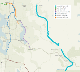
The Snoqualmie Valley Regional Trail is a King County administered trail that connects with the John Wayne Pioneer Trail in Iron Horse State Park. The 29-mile (47 km) trail follows a portion of the former alignment of the Chicago, Milwaukee, St. Paul and Pacific Railroad's Everett Branch (Cedar Falls-Everett, later shortened to Monroe, WA).
The trail begins at Rattlesnake Lake outside of North Bend and ends at McCormick Park in Duvall.
Rattlesnake Lake to Reinig Bridge
The trail parallels the Cedar Falls Road before it heads east passing Rainbow Lake and down through the Boxley Creek drainage where a trestle bridge crosses a tributary of Boxley Creek. The trail intersects the eastern edge of Riverbend subdivision and crosses South Fork of the Snoqualmie River and then makes its way under I-90 and crosses North Bend Way and makes its way through North Bend and out through Mt. Si Golf Course to Reinig Bridge at SE Reinig Road. Rough distance : 9.79 miles.[1]
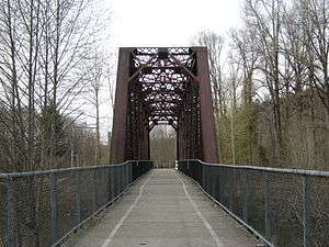
Reinig Bridge to Tokul Creek Road
Reinig Bridge crosses the Snoqualmie River and goes down a short flight of 15 steps to Meadowbrook Way Se near the intersection of SE Reinig Road. Two routes connect to the railroad grade, one via 396th Dr SE, the other on Mill Pond Road.
Tokul Creek Road to McCormick Park, Duvall
From Tokul Creek Road the trail heads west (the trail unofficially continues in an unimproved state for a quarter-mile east of Tokul Creek Road before hitting a gate at a property boundary). A mile west on the trail from Tokul Creek Road the trail crosses Tokul Creek Trestle, where deep below runs Tokul Creek gorge. From there the road parallels Fall City Road through Carnation to the city of Duvall. Rough distance : 18.4 miles.[2]
Access points
The access points to the trail are:
- Rattlesnake Lake, North Bend
- SE North Bend Way & SE Tanner Rd, North Bend
- NE 4th & Ballarat Ave, North Bend
- Three Forks off-leash Dog Park, Snoqualmie
- Tokul Creek SE, near Snoqualmie
- 356th Pl SE, near Fall City
- Nick Loutsis Park, Carnation
- McCormick Park, Duvall
Map links
| Feature | Location |
|---|---|
| Rattlesnake Lake (North Bend) | 47°25′53″N 121°45′58″W / 47.431484°N 121.766152°W |
| Reinig Bridge | 47°31′47″N 121°48′12″W / 47.529706°N 121.803467°W |
| Tokul Creek | 47°32′57″N 121°49′43″W / 47.549128°N 121.828487°W |
| McCormick Park (Duvall) | 47°44′26″N 121°59′19″W / 47.740453°N 121.988701°W |
Notes
External links
| Wikimedia Commons has media related to Snoqualmie Valley Regional Trail. |
- Snoqualmie Valley Trail Map
- Hike of the Week
- Snoqualmie Valley Regional Trail page on the King County Parks website
- King County Regional Trail Maps
| King |
|  |
|---|---|---|
| Klickitat | ||
| Pierce | ||
| Snohomish | ||
| Thurston | ||
| Whatcom |
| |
| Multiple counties |
| |