Burke-Gilman Trail
| Burke-Gilman Trail | |
|---|---|
|
A cat watches over Lake Washington and bicyclists on the Burke-Gilman Trail | |
| Length | 19.8 mi (31.9 km) |
| Location | King County, Washington |
| Use | Multi-use |
| Trail map | |
|
| |

The Burke-Gilman Sammamish Trail is a rail trail in King County, Washington. The 27-mile (43 km) multi-use recreational trail is part of the King County Regional Trail System and occupies an abandoned Seattle, Lake Shore and Eastern Railway corridor.
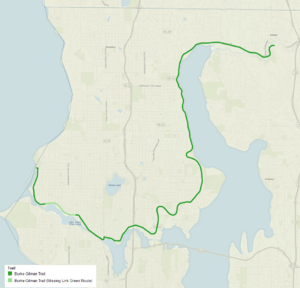
The Burke-Gilman segment is managed by the City of Seattle south of NE 145th Street. The trail begins at 11th Avenue NW in Ballard and follows along the Lake Washington Ship Canal and north along Lake Washington. At Blyth Park in Bothell the trail becomes the Sammamish River Trail and continues for 10 miles (16 km) to Marymoor Park, Redmond, on Lake Sammamish. [1] With the completion of a connector trail through Marymoor Park in May, 2009 the trail network continues to the city of Issaquah via the East Lake Sammamish Trail. With the addition of the connector, the longest unbroken segment of the trail currently extends 42 miles.[2] It runs 14.1 miles (22.7 km) between Ballard and Tracy Owen Station in Kenmore (its initial eastern end), or 17 miles (27 km) to Blyth Park. The Seattle Parks Department considers the Burke-Gilman segment of the trail to end in Kenmore;[3] The total distance from Golden Gardens Park to Bothell, including the proposed "missing link" through Ballard, is 19.8 mi (31.9 km). King County considers that the segments divide in Bothell,[1] Judge Burke and Daniel Gilman's original Road east ran past Snoqualmie Falls, before North Bend.[4]
Route and extent

The trail is a substantial part of the 90 miles (140 km) of signed bike routes in Seattle[5] and the 175 miles (282 km) of trails in the King County Trails System.[6] The newest segment of the Burke-Gilman part, opened in July 2005, runs for 0.7 miles (1.1 km) from NW 60th Street and Seaview Avenue NW to the Ballard Locks.[7] The main trail resumes at 11th Avenue NW and NW 45th Street and runs 17 miles (27 km) to Blyth Park in Bothell. There, it becomes the Sammamish River Trail segment, which parallels the Sammamish River for 10 miles (16 km) to Redmond.[1]
Currently the trail runs along the Fremont Cut, Lake Union (an old freight depot remains visible at the foot of Stone Way), and through the University of Washington campus. After passing the University Village shopping center, the trail heads up through northeast neighborhoods, alongside the Hawthorne Hills, Laurelhurst and Windermere neighborhoods; through the Sand Point neighborhood, passing Magnuson Park, then alongside Lake Washington from just before the Matthews Beach and Cedar Park neighborhoods of the former Lake City, continuing on through Lake Forest Park and Kenmore to Bothell.[3] The trail throughout is nearly level with few large intersection crossings — it is a former railroad right-of-way.
Origins and extensions
%2C_1201%2C_1202.jpg)
The trail can trace its origins to the founding of the Seattle, Lake Shore and Eastern Railway on 15 April 1885, by ten men headed by judge Thomas Burke and Daniel Gilman. In its heyday Burke and Gilman's road extended from Downtown north to Arlington and east to Rattlesnake Prairie above Snoqualmie Falls. Taken over by the Northern Pacific Railway around 1890,[4] the line became part of the Burlington Northern Railroad in 1970, and was abandoned in 1971. In 1978, the first 12.1 miles (19.5 km) of the right-of-way, from Seattle's Gas Works Park to Kenmore's Tracy Owen Station, was opened as a public trail and named after the founders of the railroad.[10] From Jerry Wilmot Park, south Woodinville, the King County Regional Trail continues along much of the old Burke and Gilman SLS&E line as the Snoqualmie Valley Regional Trail, past Duvall, through Carnation to Snoqualmie Falls, with the rail trail continuing east from North Bend as a cross-state trail from Iron Horse State Park.[11] The Snoqualmie Falls-North Bend link of Burke and Gilman's old SLS&E has become the line of the Northwest Railway Museum.[12]
As of 2006, there are extensions of the Burke-Gilman Trail at its western end: connecting the short and long segments between the Ballard Locks and 11th Avenue, and a northern extension along Shilshole Bay from NW 60th Street to Golden Gardens Park, and planning for connecting between the Ballard Locks and downtown Ballard at 11th Avenue NW and NW 45th Street.[7] A major point of contention regarding the remaining "missing link" project is the industrial nature of the Salmon Bay waterfront, through which this portion of the trail would pass. Many business owners are concerned about the safety and liability issues inherent in the convergence of trains, trucks, cyclists, and pedestrians, while the city and citizens groups claim the dangers are being exaggerated.[13] The trail overall can at times be busy and even crowded.[10]

A two-mile section of the trail within Lake Forest Park was temporarily closed for redevelopment from June 2011 to February 2012.[14]
Neighborhoods
The trail intersects the following:
- Seattle neighborhoods from western terminus east and north:
- Ballard
- Fremont
- Northlake (also known as south Wallingford)
- University District
- Trail runs alongside:
- University Village shopping center
- Hawthorne Hills
- Laurelhurst and
- Windermere neighborhoods
- Sand Point neighborhood, passing Magnuson Park
- Lake City district of neighborhoods
- Suburban Seattle towns, continuing northeast, east and then south:
See also
References
- 1 2 3 "Burke-Gilman Regional Trail". King County Parks. King County. Retrieved 2007-02-18.
- ↑ Long, Katherine (2009-05-15). "Sammamish trails tied to Burke-Gilman for a total of 42 miles". Seattle Times. Seattle Times. Retrieved 2009-05-15.
- 1 2 "Burke-Gilman Trail Information and Maps". Seattle Department of Transportation. Retrieved 2016-02-22.
- 1 2 Speidel, William (1967). Sons of the Profits, or, There's No Business Like Grow Business: The Seattle Story, 1851-1901. Nettle Creek Pub. Co. ISBN 0-914890-00-X.
- ↑ "City of Seattle Bicycle Program". Seattle DOT Bicycle Program. 2005. Retrieved 2006-04-21.
- ↑ "King County Regional Trail System". King County Parks and Recreation Division. Retrieved 2006-04-21.
- 1 2 "Burke-Gilman Trail Extension Projects". Seattle Department of Transportation (DOT) Bicycle Program. 2006-04-04. Retrieved 2006-04-21.
- ↑ Curtis, Asahel (n.d.). "Excursion on the Seattle Lake Shore and Eastern Railroad, n.d.". Asahel Curtis Photo Company Collection. University of Washington Libraries. Special Collections Division. Retrieved 2006-07-21.
- ↑ Curtis, Asahel (1887). "Opening of Seattle, Lake Shore & Eastern Railway, Seattle, ca. 1887". Lantern Slide Collection. Museum of History & Industry, Seattle. Retrieved 2006-07-21.
- 1 2 "Burke-Gilman History". Seattle DOT Bicycle Program. 2005. Retrieved 2006-04-21.
- ↑ "Snoqualmie Valley Regional Trail". King County Parks and Recreation Division. May 2006. Retrieved 2007-05-12.
- ↑ "Ride the Train". Northwest Railway Museum. Retrieved 2016-02-23.
- ↑ Bishop, Todd (2003-04-14). "Burke-Gilman extension as seen by business". Seattle Post-Intelligencer. Retrieved 2006-04-21.
- ↑ "Celebrate re-opening of Burke-Gilman Trail in Lake Forest Park, March 13" (Press release). King County Parks. 2012-03-12. Retrieved 2016-02-22.
- ↑ "North Portion of City". Seattle City Clerk's Neighborhood Map Atlas. Office of the Seattle City Clerk. Retrieved 2016-02-23.
Bibliography
- "Burke-Gilman Trail". Seattle Department of Transportation. Retrieved 2016-02-22.
- "Burke-Gilman Trail". King County Parks. King County. Retrieved 2006-04-21.
- Speidel, William C. (1967). Sons of the profits; or, There's no business like grow business: the Seattle story, 1851-1901. Seattle: Nettle Creek Publishing Company. pp. 196–197, 200. ISBN 978-0-914890-00-3.
Speidel provides a substantial bibliography with extensive primary sources.
Further reading
| Wikimedia Commons has media related to Burke-Gilman Trail. |
- "Burke-Gilman Trail Cybertour", HistoryLink Essay 7049.
- "Seattle's Bicycle Program: Bicycle Maps", Seattle Department of Transportation Bicycle Program. Also links to PDF format maps.
- "Seattle's Urban Trails System", Seattle Department of Transportation Bicycle Program. Map and description of city-wide system, completed, funded, planned.
- Burke-Gilman trail on a Google Map
- TrailLink.com - Burke Gilman Trail
| King |
|  |
|---|---|---|
| Klickitat | ||
| Pierce | ||
| Snohomish | ||
| Thurston | ||
| Whatcom |
| |
| Multiple counties |
| |
Coordinates: 47°41′44″N 122°16′41″W / 47.69556°N 122.27806°W