Soriano Department
| Soriano Department | |||
|---|---|---|---|
| |||
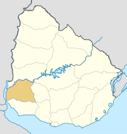 Location of Soriano Department & its capital | |||
| Coordinates (Mercedes): 33°15′S 58°2′W / 33.250°S 58.033°W | |||
| Country |
| ||
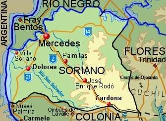
| Capital of Department | Mercedes | ||
| Government | |||
| • Intendant | Guillermo Besozzi | ||
| • Ruling party | Partido Nacional | ||
| Area | |||
| • Total | 9,008 km2 (3,478 sq mi) | ||
| Population (2011 census) | |||
| • Total | 82,594 | ||
| • Density | 9.2/km2 (24/sq mi) | ||
| Demonym(s) | Sorianense | ||
| Time zone | UYT (UTC-3) | ||
| ISO 3166 code | UY-SO | ||
| Website |
soriano | ||


Soriano is a department of Uruguay. Its capital is Mercedes. It is located on the west of the country, south of Río Negro Department, north of Colonia Department and west of Flores Department. Its western border is the Río Uruguay, separating it from Argentina.
History
In 1624, a Franciscan Mission established a reduction for the indigenous tribes of the area named Santo Domingo Soriano. In spite of interruptions in its existence, it is considered the earliest populated centre of the actual Uruguay. Eventually, in its place Villa Soriano was founded.
The first division of Uruguay in departments happened on 27 January 1816. At the time, eight departments were formed, with Soriano being one of them. When the first constitution was signed in 1830, Soriano Department was one of the nine original departments of the Republic.
Population and Demographics
As of the census of 2011, Soriano Department had a population of 82,592 (40.853 male and 41.742 female) and 32,075 households.[1]
Demographic data for Florida Department in 2010:
- Population growth rate: 0.558%
- Birth rate: 16.60 births/1,000 people
- Death rate: 9.41 deaths/1,000 people
- Average age: 31.7 (30.8 male, 32.6 female)
- Life expectancy at birth:
- Total population: 76.32 years
- Male: 73.47 years
- Female: 79.26 years
- Average per household income: 25,198 pesos/month
- Urban per capita income: 9,648 pesos/month
2010 Data Source:[2]
| Main Urban Centres | Other towns and villages | ||||||||||||||||||||||||||||||||
|---|---|---|---|---|---|---|---|---|---|---|---|---|---|---|---|---|---|---|---|---|---|---|---|---|---|---|---|---|---|---|---|---|---|
| Population stated as per 2011 census.[3] | |||||||||||||||||||||||||||||||||
|
| ||||||||||||||||||||||||||||||||
| Rural population | |||||||||||||||||||||||||||||||||
| According to the 2011 census, Soriano department has a rural population of 6,612.[1] | |||||||||||||||||||||||||||||||||
Map of the department
Noted locality
- Agraciada Beach, a historically important location in Uruguay's past, associated with the Thirty-Three Orientals.
Noted local people
- Juan Idiarte Borda, from Soriano, was President of Uruguay from 1894 to 1897
- Tomás Gomensoro Albín, from Soriano, was President of Uruguay (interim) from 1872 to 1873
See also
References
- 1 2 "Censos 2011 Soriano (needs flash plugin)". INE. 2012. Retrieved 30 August 2012.
- ↑ "Uruguay en cifras" (PDF) (in Spanish). INE. 2011. Retrieved 25 October 2012.
- ↑ "Censos 2011 Cuadros Soriano". INE. 2012. Retrieved 25 August 2012.
External links
- Official site of Soriano
- Soriano Turismo (Ministry of Tourism and Sports)
- www.todosoriano.com.uy
- INE map of Soriano Department
- Nuestra Terra, Colección Los Departamentos, Vol.7 "Soriano"
Coordinates: 33°31′0″S 57°45′0″W / 33.51667°S 57.75000°W
Capital: Mercedes | ||
| Towns and villages | 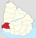 | |
| Sights | ||