Treinta y Tres Department
| Treinta y Tres Department | |||
|---|---|---|---|
| |||
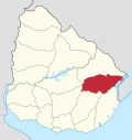
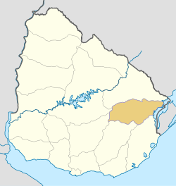 Location of Treinta y Tres Department & its capital | |||
| Coordinates (Treinta y Tres): 33°14′S 54°23′W / 33.233°S 54.383°W | |||
| Country |
| ||
| Capital of Department | Treinta y Tres | ||
| Government | |||
| • Intendant | Dardo Sánchez Cal | ||
| • Ruling party | Partido Nacional | ||
| Area | |||
| • Total | 9,529 km2 (3,679 sq mi) | ||
| Population (2011 census) | |||
| • Total | 48,134 | ||
| • Density | 5.1/km2 (13/sq mi) | ||
| Demonym(s) | Olimareño | ||
| Time zone | UYT (UTC-3) | ||
| ISO 3166 code | UY-TT | ||
| Website |
imtt | ||

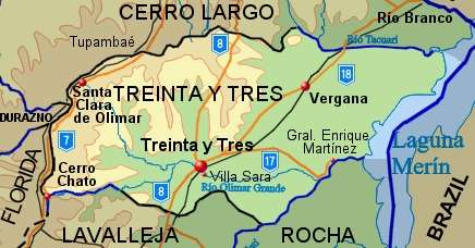
Treinta y Tres is a department of Uruguay. Its capital is Treinta y Tres. It is located in the east of the country, bordering the departments of Cerro Largo to the north, Durazno and Florida to the west, Lavalleja and Rocha to the south, while to its east is the lake Laguna Merín separating it from the southernmost end of Brazil.
History
When the First Constitution of Uruguay was signed in 1830, the territory of this department was mostly part of Cerro Largo, one of the nine original departments of the Republic. In 1853 the pueblo (village) of Treinta y Tres was created in its south. It was named after the thirty three honoured patriots who fought for and secured the Independence of the old Provincia Oriental, which became Uruguay. A permanent service of transport by horse-drawn carts between this pueblo and Montevideo was first established in 1866.[1]
On 18 September 1884 and by the Act of Ley No 1.754, the department of Treinta y Tres was created out of parts of the departments of Cerro Largo and Minas (the actual Lavalleja Department).
Population and demographics
As of the census of 2011, Treinta y Tres department had a population of 48,134 (23,416 male and 24,718 female) and 21,462 households[2]
Demographic data for Florida Department in 2010:
- Population growth rate: -0.158%
- Birth Rate: 13.80 births/1,000 people
- Death Rate: 9.15 deaths/1,000 people
- Average age: 33.7 (32.7 male, 34.6 female)
- Life Expectancy at Birth:
- Total population: 75.97 years
- Male: 72.16 years
- Female: 79.90 years
- Average per household income: 23,122 pesos/month
- Urban per capita income: 8,994 pesos/month
2010 Data Source:[3]
| Main Urban Centres | Other towns and villages | ||||||||||||||||||||||
|---|---|---|---|---|---|---|---|---|---|---|---|---|---|---|---|---|---|---|---|---|---|---|---|
| Population stated as per 2011 census.[4] | |||||||||||||||||||||||
|
| ||||||||||||||||||||||
| Rural population | |||||||||||||||||||||||
| According to the 2011 census, Treinta y Tres department has a rural population of 3,172.[2] | |||||||||||||||||||||||
Tourism
A notable natural landmark is the Quebrada de los Cuervos, 44 km east of the capital city.
Map of the department
Noted local people
- Luis Antonio Hierro López - former Vice President of Uruguay
- Luis Hierro Gambardella - former Minister, Senator and Deputy
- Luis Hierro - former Deputy
See also
References
- ↑ "Breve reseña del departamento". Intendencia de Treinta y Tres. 2011. Retrieved 19 September 2012.
- 1 2 "Censos 2011 Trenta y Tres (needs flash plugin)". INE. 2012. Retrieved 25 August 2012.
- ↑ "Uruguay en cifras" (PDF) (in Spanish). INE. 2011. Retrieved 25 October 2012.
- ↑ "Censos 2011 Cuadros Trenta y Tres". INE. 2012. Retrieved 25 August 2012.
External links
| Wikimedia Commons has media related to Treinta y Tres Department. |
- INE map of Treinta y Tres Department
- Nuestra Terra, Colección Los Departamentos, Vol.4 "Treinta y Tres"
Coordinates: 33°3′0″S 54°18′0″W / 33.05000°S 54.30000°W
Capital: Treinta y Tres | ||
| Towns and villages |
|  |
| Sights | ||