South-East Region, Ireland
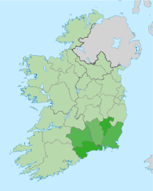
The South-East Region (coded IE024) is a NUTS Level III statistical region of Ireland. It consists of the territory of the city of Waterford and of the counties of Carlow, Kilkenny, South Tipperary, Wexford, and Waterford.[1] The South-East region spans 9,406 km2, 13.5% of the total area of the state and according to the 2006 census has a population of 460,838.
Prior to 2014, the region was governed by the South-East Regional Assembly. Statutory instrument No. 573/2014 abolished that assembly.[2][3] Since that date, the association between Regional Assemblies and NUTS regions has ceased. The NUTS regions are used for statistical reporting to Eurostat, while the Regional Assemblies are responsible for planning at a local government level.
Former Regional Authority
The South-East region was administered by the South-East Regional Authority, which consisted of 36 elected representatives including the region's representative on the EU Committee of the Regions. These representatives met once a month and were nominated from the five local government councils of the region:[1]
- Carlow County Council
- Kilkenny County Council
- South Tipperary County Council
- Waterford City Council
- Waterford County Council
- Wexford County Council
The Regional Authorities were dissolved in 2014 and were replaced by Regional Assemblies.[4] North Tipperary County Council and South Tipperary County Council were unified into a single local authority for the county on the 1st June, 2014. The current NUTS classification was released in 2013, and remains in place until the end of 2016, therefore Tipperary remains divided for statistical purposes into two different NUTS 3 regions until the next amendment to the classification is released in 2017, which will take into account the changes to the Local Administrative Units of each member state.
Demography
According to the 2006 census, the region had a population of 460,838, which constitutes 11.0% of the national population. Its population density was 49 persons per km2. The population of the regional capital, Waterford, was 49,213.[1]
The main urban centres within the region each exceed 17,000 in terms of population with an evenly distributed network of second and third-tier towns.[1] This is also supplemented by a strong rural settlement initiative.[1]
Economy
Regional GDP in 2004 was given as €11,695m, with GDP per capita forming 81.6% of the state. Its GDP per capita was 115.4% of EU25.[1] The workforce of the region in 2006 was 219,759, which equated to a 95.22% employment rate in 2007.[1]
The economy of the South-East region is primarily based on several key sectors, ranging from agriculture, to manufacturing, to services and tourism.[1] A high proportion of the regions manufacturing sector is foreign-owned. It is also an attractive area for investment due to it Industry and Technology parks a highly educated labour force bolstered by three Third Level Education Institutes.[1]
The economy is also strengthened by its good quality transport and economic infrastructure. For this prime reason the Limerick–Rosslare railway line ought have more trains and be fully reopened from Waterford railway station to Rosslare Europort and onto Wexford railway station. Tourism in the region is aided by its rich natural, historic and archaeological sites, which attract over 2 million people annually.[1]
Major settlements
A list of the ten largest settlements in the South-East region. County capitals are included and are shown in bold.
| Rank | Urban Centres | County | Population (2011 census) |
|---|---|---|---|
| 1 | Waterford | Waterford | 51,519 |
| 2 | Kilkenny | Kilkenny | 24,423 |
| 3 | Carlow | Carlow | 23,030 |
| 4 | Wexford | Wexford | 20,072 |
| 5 | Clonmel | South Tipperary | 17,908 |
| 7 | Enniscorthy | Wexford | 10,838 |
| 6 | Tramore | Waterford | 10,328 |
| 8 | Dungarvan | Waterford | 9,427 |
| 10 | Gorey | Wexford | 9,114 |
| 9 | New Ross | Wexford | 8,151 |