South Cerney
South Cerney is a village and civil parish in the Cotswold district of Gloucestershire, 3 miles south of Cirencester and close to the border with Wiltshire. It had a population of 3,074 according to the 2001 census, increasing to 3,464 at the 2011 census.[1] It was founded in 999 by Saxon settlers, with a charter by King Aethelred II. South Cerney was winner of the best kept village award, (big villages) for 2001.[2]
Culture
Arts and Theatre The Village is home to an active Theatre group called the South Cerney Players as well as an active singing group called Bluenotes.
Tourism and Recreation
Cotswold Water Park
The village of South Cerney lies within The Cotswold Water Park, an area made up of over 140 lakes, mostly formed by gravel extraction. Many of the lakes are now used for leisure activities including fishing and sailing.
South Cerney Sailing Club
South Cerney Sailing Club is well established in the Cotswold Water Park.
Outdoor Education Centre
South Cerney is also home to the South Cerney Outdoor Education Centre which was created in 1971 by Gloucestershire County Council as a non-profit organisation to promote outdoor learning and provide low cost outdoor activities for young people.
Kids activities The village is also home to active Beaver, Cubs and Scouts, meeting on Thursday evenings, and Guides who meet on Tuesday evenings, all at The Jim Denley Scout Headquarters in Berkeley Close. The Brownie Pack meet in the village hall located in School Lane on Wednesdays from 5:45-7:00.
Social Activities
- South Cerney Flower Show
- South Cerney Gardening Club.
- The C.O.S.Y Club (Cerney Over Sixty Years Club).
- South Cerney Stragglers
- Cerney Lakes Tennis Club
Local Amenities
South Cerney has a range of local amenities including a Post Office and newsagents (known as South Cerney News), Spar general store, hairdressers, a fish and chip shop, an Indian restaurant/takeaway, pharmacy and a dental surgery. There are 3 public houses in South Cerney, The Old George, The Royal Oak and The Eliot Arms Hotel.
Duke of Gloucester Barracks is located approximately 1 mile outside the Village.
It's also home to South Cerney Golf course. South Cerney Golf Course & Driving Range is a par 70 - 5,987yrds course.
Ann Edwards Primary School
Ann Edwards School is also located within the village. The name of the school was adopted when the buildings were located on the present site in 1970.
Ann Edwards lived in South Cerney and was actively involved in education in the early 19th century. She was the wife of the village curate and ran a dame school. When her husband unexpectedly came into money, she endowed the first school building which was opened in 1820. It was a Church of England Foundation School and we know from early records, that there were 29 pupils in 1867. The colours of the Coat of Arms of Ann Edwards - black and gold - have been adopted as the colours of the school uniform in memory of the founder.
The original building still stands in School Lane; it was used as a school until 1972 when it was outgrown and children moved to buildings on the present site. These were demolished in 1990, having been replaced by a modern, purpose-built school.
The present school is a Voluntary Controlled Church of England Primary School. It serves the communities of South Cerney, Cerney Wick, and Somerford Keynes. The current Headteacher, Miss Helen Sowden was appointed as Headteacher with effect from September 2014, following the death of Headteacher, Stephen Richardson.
The school was designed as a semi open-plan building by a local architect and stands on a landscaped site of approximately six acres.
The re-built school was formally opened by Pam Ayres in 1990.
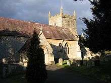
South Cerney Church and Ann Edwards School
The South Cerney church contains a replica of a beautiful carved wooden head and foot of Christ. Part of a crucifix that dates from the 12th Century, it is one of very few early medieval sculptures of Christ extant in England. The original is kept at the British Museum.[3]At the end of Silver Street in South Cerney is the Ann Edwards School, founded by Ann Edwards in 1834. And in nearby Station Road, an attractive row of gabled cottages dates from the 16th and 17th Centuries. The remains of some of the old railway line can also be found in this area of the village.
Wildlife
South Cerney is well endowed with numerous land and water dwelling species native to England including swans and muntjac deer.
Governance
South Cerney has an active Parish Council with 11 members. The current Chairman is local solicitor Philip Nicholas.
Cotswold District Council undertook a boundary review which resulted in the former 'Water Park' Ward being replaced. As of May 2015 the village was split into two District Council Wards, 'South Cerney Village' which elected Liberal Democrat Councillor Juliet Layton and 'Siddington and Cerney Rural' which elected Shaun Parsons a Conservative. Both were elected in the 2015 local elections.
South Cerney Village Ward
| Party | Candidate | Votes | % | ± | |
|---|---|---|---|---|---|
| Liberal Democrat | Juliet Layton | 707 | 48.6 | ||
| Conservative | Michael Darlington | 433 | 29.8 | ||
| Independent | Alan Dickinson | 314 | 21.6 | ||
| Majority | 274 | ||||
| Turnout | 73.96 | ||||
| Liberal Democrat hold | Swing | ||||
Siddington and Cerney Rural Ward
| Party | Candidate | Votes | % | ± | |
|---|---|---|---|---|---|
| Conservative | Shaun Parsons | 702 | 51.5 | ||
| Liberal Democrat | Jordan McKenna | 662 | 48.5 | ||
| Majority | 40 | ||||
| Turnout | 69.28 | ||||
| Conservative hold | Swing | ||||
The village is also represented on Gloucestershire County Council by Shaun Parsons who represents the large rural South Cerney Division.
Development
There are several industrial areas which have sprung up on the outskirts of South Cerney, bringing more requirements for housing and a large estate was built on the land sold by Aggregate Industries some years ago.
South Cerney has a growing business community with many companies occupying the industrial and business estates that have built up on the outskirts of South Cerney.
Transportation
Cirencester is located at the hub of a significant road network with important routes to Gloucester (A417), Cheltenham (A435), Warwick (A429 "Fosseway"), Oxford (A40 via the B4425), Swindon (A419), Chippenham (A429), Bristol and Bath (A433), and Stroud (A419).
The nearest railway station is a few miles away at Kemble which is on the main line to London (Paddington).
The nearest airports are at Bristol, Cardiff and Birmingham, all more than an hour away by road.
See also
References
- ↑ "Parish population 2011.Retrieved 26 March 2015".
- ↑ Hartland, Dom. "South Cerney Village Website". therealsouthcerney.co.uk.
- ↑ British Museum Collection
External links
![]() Media related to South Cerney at Wikimedia Commons
Coordinates: 51°40′16″N 1°55′55″W / 51.671°N 1.932°W
Media related to South Cerney at Wikimedia Commons
Coordinates: 51°40′16″N 1°55′55″W / 51.671°N 1.932°W
- southcerney.org.uk Parish Council website