South Dakota Highway 30
| ||||
|---|---|---|---|---|
|
Route of SD 30 (in red) | ||||
| Route information | ||||
| Defined by SDCL §31-4-154 | ||||
| Maintained by SDDOT | ||||
| Length: | 17.077 mi[1] (27.483 km) | |||
| Existed: | 1954 (approx.) – present | |||
| Major junctions | ||||
| West end: |
| |||
| East end: |
| |||
| Location | ||||
| Counties: | Brookings | |||
| Highway system | ||||
| ||||

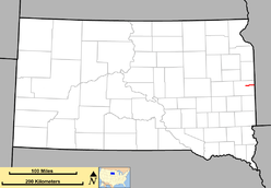
South Dakota Highway 30 (SD 30) is a state route located in east central South Dakota. It begins at Interstate 29 west of White, and runs easterly to the Minnesota border, becoming Minnesota State Highway 19. It is 17 miles (27 km) in length.
Route description
South Dakota Highway 30 begins at a diamond interchange with Interstate 29 and heads east for about six miles before curving to the northeast, bypassing the town of White. The highway then curves to the east again, traveling in that direction for about 8.5 miles (13.7 km) before crossing into Minnesota and becoming Minnesota State Highway 19.[2]
The route of SD 30 is defined in South Dakota Codified Laws § 31-4-154.[3]
History
This is the second usage of the South Dakota 30 identifier.
The initial South Dakota 30 was assigned in the 1920s, to the route of the Black and Yellow Trail. It began at the Wyoming border southwest of Lead, and ran eastward across the state to the Minnesota border near Elkton. The number was replaced around 1926 with the implementation of the U.S. highway system. The Wyoming to Sturgis segment became U.S. Route 85, the Sturgis to Midland segment South Dakota Highway 65, and the Hayes to Minnesota segment U.S. Route 14.
The present South Dakota 30 was implemented around 1954, consisting of two segments. One segment ran from South Dakota Highway 25 north of De Smet, to U.S. Route 81 south of Lake Poinsett; the second segment extended from U.S. Route 77 east to the Minnesota border. These two segments were connected by 1960.
The western terminus was pulled back to US 77 (I-29) by 1965.
Major intersections
The entire route is in Brookings County.
| Location | mi[1] | km | Destinations | Notes | |
|---|---|---|---|---|---|
| Sterling Township | 0.000 | 0.000 | Roadway continues as CR 6 | ||
| Afton Township | 1.537 | 2.474 | I-29 exit 140. | ||
| Lake Hendricks Township | 17.077 | 27.483 | Continuation into Minnesota | ||
| 1.000 mi = 1.609 km; 1.000 km = 0.621 mi | |||||
References
- 1 2 "Aberdeen Region Highway Log" (PDF). Aberdeen: South Dakota Department of Transportation. February 3, 2015: 90. Retrieved December 8, 2015.
- ↑ "Google Maps Overview of SD 30". Retrieved November 3, 2012.
- ↑ "South Dakota Codified Law". Retrieved November 3, 2012.