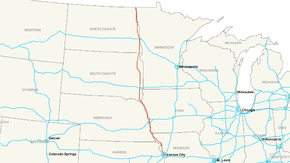
Interstate 29
| |
|---|---|
 | |
| Route information | |
| Length: | 750.58 mi[1] (1,207.94 km) |
| Major junctions | |
| South end: |
|
|
| |
| North end: |
|
| Location | |
| States: | Missouri, Iowa, South Dakota, North Dakota |
| Highway system | |

Interstate 29 (I-29) is an Interstate Highway in the Midwestern United States. I-29 runs from Kansas City, Missouri, at a junction with Interstate 35 and Interstate 70, to the Canada–US border near Pembina, North Dakota, where it connects with Manitoba Highway 75.[2]
The road follows the course of three major rivers, all of which form the borders of U.S. states. The southern portion of I-29 closely parallels the Missouri River from Kansas City northward to Sioux City, Iowa, where it crosses and then parallels the Big Sioux River. For the northern third of the highway, it closely follows the Red River of the North.
Residents of Missouri, Arkansas and Louisiana began campaigning in 1965 via the "US 71 - I-29 Association" to extend the highway all the way to New Orleans, Louisiana following the US 71 corridor.[3] The campaign would create a limited access highway from New Orleans to Canada and on to Winnipeg. That extension would be called Interstate 49 which was not part of the 1957 master plan. It is named 49 instead of 29 because of interstate naming rules. The rules state that north-south roads are odd numbered and the highways are named in increasing order from west to east. Since there are an Interstate 35 and an Interstate 45 to the west and an Interstate 55 to the east Interstate 49 was chosen for the name.[4] Interstate 35 angles from the west to the east side of I-29 from its origin in Kansas City. The next interstate on the west side is Interstate 25 in Colorado and Wyoming and hence the 29 designation by naming rules.
Route description
| mi | km | |
|---|---|---|
| MO | 128.71 | 207.14 |
| IA | 151.83 | 244.35 |
| SD | 252.50 | 406.36 |
| ND | 217.54 | 350.10 |
| Total | 750.58 | 1207.94 |
Missouri
Near its southern terminus, I-29 is concurrent with I-35 and U.S. Route 71. The interstate diverts from U.S. 71 just north of St. Joseph and follows a sparsely populated corridor along the Missouri River to Council Bluffs. During the design phase there was an alternative sending the route further along U.S. 71 through the bigger towns of Maryville, Missouri, and Clarinda, Iowa. During the Great Flood of 1993 the Missouri River flooded this section and traffic was rerouted to U.S. 71 through Maryville and Clarinda. I-29 was closed again for about two months during the 2011 Missouri River Flood.
Almost all of I-29 in Missouri is in an area called the Platte Purchase that was not originally part of Missouri when it entered the Union.
Iowa
Interstate 29 begins in Iowa near Hamburg. It goes northwest to an interchange with Iowa Highway 2, then goes north until Council Bluffs. In Council Bluffs, it runs concurrent with Interstate 80. It winds its way along the western and northern edges of Council Bluffs after separating from I-80. North of Council Bluffs, I-29 runs concurrent with Interstate 680 between Exits 61 and 71. After Interstate 680 separates, I-29 continues on a northwesterly path toward Sioux City. At Sioux City, Interstate 129 spurs off of I-29 to go west toward South Sioux City, Nebraska. After continuing toward downtown Sioux City on a northerly route, I-29 turns west and enters South Dakota.
South Dakota
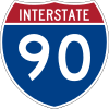
Interstate 29 enters South Dakota at North Sioux City by crossing over the Big Sioux River. It runs northwest until its interchange with South Dakota Highway 50 near Vermillion, where it turns north. The highway alignment is due north until just before Sioux Falls. In the Sioux Falls area, I-29 serves the western part of Sioux Falls while I-229 spurs off and serves eastern Sioux Falls. In northwestern Sioux Falls, I-29 meets Interstate 90. After that, it continues north past Brookings and an intersection with US 14. At the intersection with South Dakota Highway 28, I-29 turns northwest toward Watertown. After Watertown, the highway continues north and passes an intersection with US 12 before continuing into North Dakota.
North Dakota
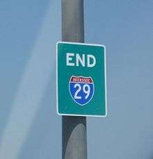
Interstate 29 enters North Dakota from the south, near Hankinson. At Fargo, it meets Interstate 94 and continues north along the Red River toward Grand Forks. At its northern terminus, I-29 enters Canada and becomes Manitoba Provincial Trunk Highway 75, which leads to Winnipeg.
History
The portion from Fargo, North Dakota, to the Canada–US border was originally considered for designation as Interstate 31 in 1957 for present-day I-29.[5] No freeway was initially planned south of Fargo. However, it was subsequently decided in 1958 to connect I-29 and I-31 between Sioux Falls and Fargo. The entire freeway was then built and numbered as I-29.[6]
Junction list
- Missouri
-


 I‑35 / I‑70 / US 24 / US 40 / US 71 in Kansas City. I-29/I-35 travels concurrently through Kansas City. I-29/US 71 travels concurrently to east of Amazonia.
 -
 US 69 on the Gladstone–Kansas City city line
 -
 US 169 on the Gladstone–Kansas City city line
 -
 I‑635 in Kansas City
 -
 I‑435 in Kansas City. The highways travel concurrently to Platte City.
 -
 I‑229 south-southeast of St. Joseph
 - US 169 in St. Joseph
-
 US 36 in St. Joseph
 - US 169 in St. Joseph
-
 US 59 north-northeast of Country Club. The highways travel concurrently to east of Amazonia.
 - I‑229 / US 59 / US 71 east of Amazonia
- US 59 northwest of Amazonia. The highways travel concurrently for approximately 1.8 miles (2.9 km).
- US 59 north of Oregon
-
 US 159 south-southeast of Mound City
 - US 59 east of Craig
-
 US 136 in Rock Port
 - Iowa
-

 US 34 / US 275 west of Glenwood. I-29/US 275 travels concurrently to Council Bluffs.
 -
 I‑80 in Council Bluffs. The highways travel concurrently through Council Bluffs.
 -

 I‑480 / US 6 in Council Bluffs
 -
 I‑680 west-southwest of Crescent. The highways travel concurrently to west-southwest of Loveland.
 -
 US 30 in Missouri Valley
 -


 I‑129 / US 20 / US 75 in Sioux City
 -
 US 77 in Sioux City
 - South Dakota
-
 US 18 south-southwest of Worthing. The highways travel concurrently for approximately 3.02 miles (4.86 km).
 - I‑229 in Sioux Falls
-
 I‑90 in Sioux Falls
 -
 US 14 in Brookings
 -
 US 212 in Watertown
 -
 US 81 northeast of Watertown. The highways travel concurrently to east of Manvel, North Dakota.
 -
 US 12 northwest of Summit
 - North Dakota
-

 I‑94 / US 52 in Fargo
 -
 US 10 in Fargo
 -
 US 2 in Grand Forks
 - US 81 south-southwest of Joliette. The highways travel concurrently to the Canada–United States border north of Pembina.
- US 81/
 PTH 75 at the Canada–United States border north of Pembina
Auxiliary routes
See also
Business routes
- Interstate 29 Business in St. Joseph, Missouri
References
- ↑ Federal Highway Administration (2002-10-31). "FHWA Route Log and Finder List: Table 1". Retrieved 2007-03-28.
- ↑ "Overview Map of I-29". Google Maps. Retrieved 2008-02-15.
- ↑ "Newspapers.com search". Newspapers.com.
- ↑ "I-49 Conversion".
- ↑ Official Route Numbering for the National System of Interstate and Defense Highways, August 14, 1957
- ↑ Official Route Numbering for the National System of Interstate and Defense Highways, June 27, 1958
External links
| Wikimedia Commons has media related to Interstate 29. |
| Signed | |||||||||||
|---|---|---|---|---|---|---|---|---|---|---|---|
| Unsigned | |||||||||||
| Lists |
| ||||||||||
Major Interstates highlighted | |||||||||||