South Fork Bull Run River
| South Fork Bull Run River | |
| Name origin: Possibly after cattle that escaped and ran wild along the river between 1849 and 1855[1] | |
| Country | United States |
|---|---|
| State | Oregon |
| County | Clackamas County |
| Source | Mount Hood National Forest |
| - location | Township Meadow, Clackamas County, Oregon |
| - elevation | 3,260 ft (994 m) [2] |
| - coordinates | 45°26′02″N 121°59′20″W / 45.43389°N 121.98889°W [3] |
| Mouth | Bull Run River |
| - location | Bull Run Reservoir 2, Clackamas County, Oregon |
| - elevation | 863 ft (263 m) [3] |
| - coordinates | 45°27′08″N 122°07′21″W / 45.45222°N 122.12250°WCoordinates: 45°27′08″N 122°07′21″W / 45.45222°N 122.12250°W [3] |
| Length | 6 mi (10 km) [4] |
| Basin | 15.4 sq mi (40 km2) [5] |
| Discharge | for 0.6 miles (0.97 km) from the mouth |
| - average | 111 cu ft/s (3 m3/s) [5] |
| - max | 3,630 cu ft/s (103 m3/s) |
| - min | 5.4 cu ft/s (0 m3/s) |
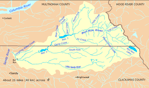 Bull Run River watershed | |
 Location of the mouth of the South Fork Bull Run River in Oregon | |
The South Fork Bull Run River is a tributary, about 6 miles (9.7 km) long, of the Bull Run River in the U.S. state of Oregon. Part of the system that provides drinking water to the city of Portland, it flows generally west through a protected part of the Mount Hood National Forest in Clackamas County. It joins the Bull Run River at Bull Run Reservoir 2, about 8 miles (13 km) from the larger stream's confluence with the Sandy River.
Course
The river, which begins in Township Meadow in the Mount Hood National Forest, flows northwest and then west through Clackamas County and the Mount Hood National Forest. It receives its only named tributary, Cedar Creek, from the right before reaching a United States Geological Survey (USGS) stream gauge 0.6 miles (0.97 km) from the mouth. The South Fork joins the main stem Bull Run River at the larger stream's river mile (RM) 8 or river kilometer (RK) 13, near the midpoint of Bull Run Reservoir 2.[6]
Discharge
Since 1974, the USGS has monitored the flow of the South Fork Bull Run River at a stream gauge 0.6 miles (0.97 km) from the mouth. The average flow between then and 2008 was 111 cubic feet per second (3.1 m3/s). This is from a drainage area of 15.40 square miles (39.89 km2). The maximum flow recorded during this period was 3,630 cubic feet per second (103 m3/s) on February 7, 1996. The minimum was 5.4 cubic feet per second (0.15 m3/s) on October 13, 1994.[5]
Watershed
The Bull Run River watershed, which includes the South Fork Bull Run River, drains 139 square miles (360 km2).[7] The basin, which is the main source of Portland's drinking water, is largely restricted to uses related to water collection, storage, treatment, and forest management. The South Fork Bull Run River basin of about 15.4 square miles (40 km2) amounts to about 11 percent of the total Bull Run River watershed,[5] which is managed by the Portland Water Bureau and the United States Forest Service.[8]
See also
References
- ↑ McArthur, p. 123
- ↑ Source elevation derived from Google Earth search using GNIS source coordinates.
- 1 2 3 "South Fork Bull Run River". Geographic Names Information System (GNIS). United States Geological Survey. November 28, 1980. Retrieved December 26, 2009.
- ↑ Oregon Atlas and Gazetteer (Map) (2008 ed.). DeLorme Mapping. § 29–30. ISBN 978-0-89933-347-2. Approximate length determined by map scale and ruler.
- 1 2 3 4 "Water-data report 2008: South Fork Bull Run River near Bull Run, OR" (PDF). United States Geological Survey. Retrieved December 26, 2009. Stated watershed size includes only that part of the watershed above river mile 0.6 (river kilometer 1).
- ↑ United States Geological Survey (USGS). "United States Geological Survey Topographic Map, Hickman Butte and Brightwood quadrants". TopoQuest. Retrieved December 26, 2009.
- ↑ Portland Water Bureau, "Landscape Conditions", p. 52
- ↑ "Map of Bull Run Management Unit". Portland Water Bureau. Retrieved December 27, 2009.
Works cited
- McArthur, Lewis A., and McArthur, Lewis L. (2003) [1928]. Oregon Geographic Names, 4th edition. Portland: Oregon Historical Society Press. ISBN 0-87595-277-1.
- Portland Water Bureau (2007). "Landscape Conditions", Chapter 4 of Current Habitat Conditions in the Habitat Conservation Plan Area. Portland, Oregon: Portland Water Bureau. Retrieved March 9, 2010.
External links
- Sandy River Basin Watershed Council
- Sandy River Basin Partners
- Forest Service, Mount Hood National Forest
Rivers and streams of Portland, Oregon | ||
|---|---|---|
| Major |  | |
| Minor | ||
| Drinking water | ||