South Glamorgan
Coordinates: 51°29′56″N 3°19′48″W / 51.499°N 3.330°W
| South Glamorgan Welsh: De Morgannwg | |
|---|---|
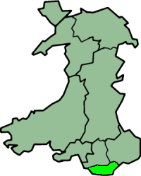 South Glamorgan shown within Wales as a preserved county | |
| Area | |
| • 2003 |
475 km² Ranked 8th |
| Population | |
| • 2007 |
445,000 (est; 2003 borders)[1] Ranked 3rd |
| History | |
| • Created | 1974 |
| • Abolished | 1996 |
| • Succeeded by |
Cardiff Vale of Glamorgan Preserved county of South Glamorgan |
| Status | Non-metropolitan county (1974–1996) Preserved county (1996–) |
| Chapman code | SGM |
| Government |
South Glamorgan County Council |
| • HQ | Cardiff Bay |
| Subdivisions | |
| • Type | Non-metropolitan districts |
| • Units |
1. City of Cardiff 2. Vale of Glamorgan |
South Glamorgan (Welsh: De Morgannwg) is a preserved county of Wales.
It was originally formed in 1974 under the Local Government Act 1972, as a county council area. It consisted of the county borough of Cardiff along with the southern part of the administrative county of Glamorgan, and also the parish of St Mellons from Monmouthshire.
These areas were divided between two districts: Cardiff and Vale of Glamorgan. Of the counties created in the Act, this was an unusually low number of districts, with only the Isle of Wight being the only other county with two. As well as Cardiff, the county included the main towns of Barry, Cowbridge, Llantwit Major and Penarth.
Local government of the county was shared, sometimes in conflict, between South Glamorgan County Council, Cardiff City Council and the Vale of Glamorgan Borough Council.[2]
Following the Local Government (Wales) Act 1994, South Glamorgan was abolished on 1 April 1996, with both district councils becoming unitary authorities. These new authorities each also included small parts of Mid Glamorgan, with Wick, St Brides Major, and Ewenny transferred to the Vale of Glamorgan from the Ogwr district, while Pentyrch and Creigiau (from the Taff-Ely district) became part of Cardiff.
South Glamorgan continues in existence as a preserved county for purposes such as lieutenancy, and as such includes those communities.
References
- ↑ 2007 population estimate, calculated using 2003 borders for Cardiff and Vale of Glamorgan. Source: "Table 10: Mid-2006 to Mid-2007 Population Estimates, Components of population change for local authorities in the United Kingdom". Office for National Statistics. Retrieved 2010-09-11.
- ↑ Alan Hooper; John Punter (Eds.) Capital Cardiff 1975-2020: Regeneration, Competitiveness and the Urban Environment. University of Wales Press (2006), pp. 31-34. ISBN 0-7083-2063-5.