Spencers Wood
| Spencers Wood | |
 The Chapel, Spencers Wood |
|
 Spencers Wood |
|
| Population | 4,019 2011 Census |
|---|---|
| Civil parish | Shinfield |
| Unitary authority | Wokingham |
| Ceremonial county | Berkshire |
| Region | South East |
| Country | England |
| Sovereign state | United Kingdom |
| Post town | Reading |
| Postcode district | RG7 |
| Dialling code | 0118 |
| Police | Thames Valley |
| Fire | Royal Berkshire |
| Ambulance | South Central |
| EU Parliament | South East England |
| UK Parliament | Wokingham |
Coordinates: 51°23′40″N 0°58′20″W / 51.3944°N 0.9722°W
Spencers Wood is a village in the civil parish of Shinfield, Berkshire, England, 4 miles (6.4 km) south of Reading. The village of Three Mile Cross adjoins it to the north. To the west lies the village of Grazeley.
History

The village was named after the le Despencer family — a Norman family – in the 13th century. Until about 1300, the village was part of the Royal Forest (Windsor Forest).
In the 13th century, Spencers Wood was administered by William Longespée, Earl of Salisbury and his court in Amesbury. Hence at that time Spencers Wood was part of Wiltshire (as was much of the surrounding area). Nearby Swallowfield was split between Wiltshire and Berkshire, with Part Lane marking the partition. In fact, it was only on 20 October 1844 that Spencers Wood and the surrounding areas became part of Berkshire. In 1860, most of the land, which was hitherto common land, was enclosed and separately acquired by two local gentlemen; the local philanthropist Frederick Allfrey, and William Merry, who was a County magistrate and a visiting magistrate to Reading Gaol, as well as Secretary at War Lord Palmerston's private secretary from 1812 to 1828.
By 1880, Spencers Wood had become a thriving village with a population of 600, of whom 200 were children. Most of the working men worked in the fields or were in domestic service. Victorian and Edwardian style houses were built along the Basingstoke Road using bricks baked at the local Swain family kiln. The Square became the heart of the village during this building period. Many of the houses still stand.
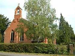
In spite of its growth, Spencers Wood was still split between the ecclesiastical parishes of Shinfield, Swallowfield and Grazeley. This changed in 1908 when the Church of St Michael and All Angels was consecrated. The boundaries were finally officially changed five years later, although some parts of the village were still in the ecclesiastical parish of Grazeley. Also on 1908, the local school was opened, which ended the necessary walk to Swallowfield's Russell Hall, Shinfield or Grazeley School.[1]
World War Two
Spencers Wood, being a rural community, was unaffected by the Blitz. Few German bombs fell in the area, which was just as well as the village has no air-raid shelters. One German plane was shot down locally.
Rationing also had little effect on the village as the majority of villagers were too poor to notice a real reduction in goods. Food was grown and caught locally as part of the dig for victory programme and the black-market was able to supply all excess demand.
The main impact of the war was the influx of people. Two coaches of evacuees arrived in the village in September 1939. Evacuee children and local children were educated separately until Christmas 1939. Canadian forces were stationed in the village for a while, and a small POW camp was opened after the Canadians relocated. Some POWs helped on the local farms. The village hall served as the Local Defence Volunteers headquarters. Basingstoke Road was the main road to Aldershot, and frequent troop convoys ran through the village.
After the war, many soldiers, evacuees and prisoners of war decided to settle in the village, in addition to this, a baby boom helped the population of the village to grow.
Recent history

The first street lighting in the village was installed after the war.
In 1954, Spencers Wood Women's Institute was formed. It was quite successful, with 60 members at its height. It closed in the mid-1980s.
In the 1960s, the M4 Motorway was built and became a man made barrier between the village and Reading. In the 1980s, the A33 Swallowfield Bypass severed roads to the village of Grazeley lying to the East.
Despite local opposition, many new houses have been constructed in the village in recent years.
Village Services
- Double's Garage is a petrol station and car mechanic on the Basingstoke Road. It is a business that has been family owned for over 100 years, which started out as a blacksmith and farrier in The Square, the centre of the village. Their original site still stands, although it will soon be replaced by two modern houses.
- Hampshire company Fleet Buzz, part of the Stagecoach Group, provide a regular bus service (No 72) through the village, with buses every hour Mondays to Saturdays. They are the latest of a plethora of bus companies to serve the village, which started with Cordery's Garage. The prices of the earliest return tickets to Reading were 11d (approx 5p), although for just over double (2 shilling, exactly 10p) a weekly ticket was available. As of 2014, a single ticket to Reading is £3.10, with a return for £4.50. Reading Buses operate a service to the village on weekday evenings (82) and Sundays (82K).
- The bakery, now operated by Warings, has always been a bakers. Although it is now part of a chain, the bread is still baked locally. Originally, it was one of three bakers in the village.
- The local library is part of Wokingham Borough Council's Libraries. The building was originally an infants school.
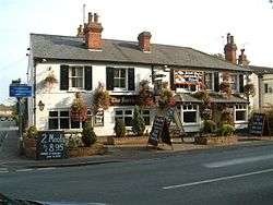
- The local pub is called The Farriers' Arms, although it was briefly called The Cygnet when it was purchased by the owner of The Swan (a pub in neighbouring Three Mile Cross). Before the Swallowfield Bypass was built, it was a popular place for coaches to stop on their way to the south coast, so much so that reservations were required. It is a very old business, although originally only a beer house. A full licence was granted after the First World War. In recent times, it has expanded to incorporate two adjacent cottages, making it significantly larger than the original beer house. Originally there were many more pubs in Spencers Wood.
- The Hop Inn is the local off-licence. The building was originally a pub called The Cricketers, although it was one of the village butchers for a while.
- An Indian restaurant has recently arrived in the village. It is not the first Indian business to serve Spencers Wood, an Indian tablecloth and silk tie trader served the village before World War Two.
- A chemist now occupies the building that was Harrisons Grocery Store and Provision Shop. During World War One, it was known as Farleys. The existence of this chemist prohibits the majority of the village population from making use of the chemist at Swallowfield Surgery.[2]
- The Grovelands Garden Centre was a family run business until 2006 when Dobbies Garden Centres took it over. Dobbies has since been bought by Tesco.
- The village post office is on the Basingstoke Road. It has been a post office since 1885, and was a manual telephone exchange until 1934. In November 1992 the post office was the scene of a bloodless armed robbery, no-one was arrested for the crime. The oldest surviving postbox in the village dates from King George V's reign.
- Two hairdressers serve the village. One used to be a harness maker.
- The local builder's merchant, Meakin Building Supplies Ltd, has been established since 1981 in Lambs Lane, prior to which it operated from that site as a haulage company, Meakin Transport. The haulage company moved to Back Lane several years after the builder's merchant began to thrive. The haulage company site in Back Lane was originally known as Judd's yard and was previously a sawmill.
- The village has two areas with allotments.
References
External links
![]() Media related to Spencers Wood at Wikimedia Commons
Media related to Spencers Wood at Wikimedia Commons