Spitz, Austria
| Spitz | ||
|---|---|---|
 | ||
| ||
 Spitz Location within Austria | ||
| Coordinates: 48°21′N 15°25′E / 48.350°N 15.417°ECoordinates: 48°21′N 15°25′E / 48.350°N 15.417°E | ||
| Country | Austria | |
| State | Lower Austria | |
| District | Krems-Land | |
| Government | ||
| • Mayor | Hannes Hirtzberger | |
| Area | ||
| • Total | 23.83 km2 (9.20 sq mi) | |
| Elevation | 223 m (732 ft) | |
| Population (1 January 2016)[1] | ||
| • Total | 1,615 | |
| • Density | 68/km2 (180/sq mi) | |
| Time zone | CET (UTC+1) | |
| • Summer (DST) | CEST (UTC+2) | |
| Postal code | 3620 | |
| Area code | 02713 | |
| Website | www.spitz-wachau.at | |

Spitz an der Donau is a market town in the district of Krems-Land in the Austrian state of Lower Austria, further down from Willendorf on the left bank of the Danube.
History
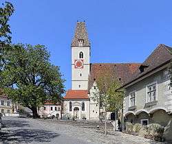
Occupied since Celtic times, it was first mentioned in 830. A hill "Tausendeimerberg" (the "Hill of a Thousand Buckets") is so named because of the many grapes that grow there, for the Wachau valley, for which Spitz is in, is famous for them. The Late Gothic church to St. Maurice is famous for its Apostles (1380) and an altarpiece by Kremser Schmidt. To the south of Spitz is the famous fortress of Hinterhaus.
In February 2008, Spitz made an appearance in domestic news following the poisoning of then–mayor Dr. Hannes Hirtzberger.[2]
Population
| Historical population | ||
|---|---|---|
| Year | Pop. | ±% |
| 1971 | 2,134 | — |
| 1981 | 2,025 | −5.1% |
| 1991 | 1,931 | −4.6% |
| 2001 | 1,769 | −8.4% |
External links
References
| Wikivoyage has a travel guide for Spitz. |
This article is issued from Wikipedia - version of the 10/28/2016. The text is available under the Creative Commons Attribution/Share Alike but additional terms may apply for the media files.