Spodnje Dobrenje
| Spodnje Dobrenje | |
|---|---|
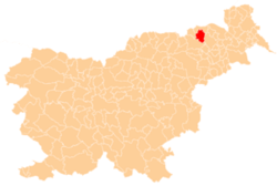
 Spodnje Dobrenje Location in Slovenia | |
| Coordinates: 46°37′21.64″N 15°39′30.72″E / 46.6226778°N 15.6585333°ECoordinates: 46°37′21.64″N 15°39′30.72″E / 46.6226778°N 15.6585333°E | |
| Country |
|
| Traditional region | Styria |
| Statistical region | Drava |
| Municipality | Pesnica |
| Area | |
| • Total | 3.95 km2 (1.53 sq mi) |
| Elevation | 264.9 m (869.1 ft) |
| Population (2002) | |
| • Total | 416 |
| [1] | |
Spodnje Dobrenje (pronounced [ˈspoːdnjɛ dɔˈbɾeːnjɛ]) is a dispersed settlement in the Municipality of Pesnica in northeastern Slovenia. It lies in the Slovene Hills (Slovene: Slovenske gorice). The area was part of the traditional region of Styria. The municipality is now included in the Drava Statistical Region.[2]
The A1 motorway runs through the entire length of the settlement.
References
External links
| Settlements | Administrative centre: Pesnica pri Mariboru
|  |
|---|---|---|
| Landmarks |
| |
This article is issued from Wikipedia - version of the 6/9/2016. The text is available under the Creative Commons Attribution/Share Alike but additional terms may apply for the media files.