Polička Vas
| Polička Vas | |
|---|---|
 Polička Vas Location in Slovenia | |
| Coordinates: 46°39′35.62″N 15°41′38.42″E / 46.6598944°N 15.6940056°ECoordinates: 46°39′35.62″N 15°41′38.42″E / 46.6598944°N 15.6940056°E | |
| Country |
|
| Traditional region | Styria |
| Statistical region | Drava |
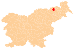
| Municipality | Pesnica |
| Area | |
| • Total | 2.89 km2 (1.12 sq mi) |
| Elevation | 340.1 m (1,115.8 ft) |
| Population (2002) | |
| • Total | 196 |
| [1] | |
Polička Vas (pronounced [pɔˈliːtʃka ˈʋaːs]; Slovene: Polička vas) is a settlement in the Slovene Hills (Slovene: Slovenske gorice) in northeastern Slovenia. It lies in the Municipality of Pesnica. Traditionally the area was part of Styria. The municipality is now included in the Drava Statistical Region.[2]
References
External links
| Settlements | Administrative centre: Pesnica pri Mariboru
|  |
|---|---|---|
| Landmarks |
| |
This article is issued from Wikipedia - version of the 6/8/2016. The text is available under the Creative Commons Attribution/Share Alike but additional terms may apply for the media files.