Sprockhövel
| Sprockhövel | ||
|---|---|---|
| ||
 Sprockhövel | ||
Location of Sprockhövel within Ennepe-Ruhr-Kreis district 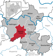
 | ||
| Coordinates: 51°22′N 7°15′E / 51.367°N 7.250°ECoordinates: 51°22′N 7°15′E / 51.367°N 7.250°E | ||
| Country | Germany | |
| State | North Rhine-Westphalia | |
| Admin. region | Arnsberg | |
| District | Ennepe-Ruhr-Kreis | |
| Government | ||
| • Mayor | Klaus Walterscheid (SPD) | |
| Area | ||
| • Total | 47.78 km2 (18.45 sq mi) | |
| Population (2015-12-31)[1] | ||
| • Total | 25,205 | |
| • Density | 530/km2 (1,400/sq mi) | |
| Time zone | CET/CEST (UTC+1/+2) | |
| Postal codes | 45549 | |
| Dialling codes | 02339, 02324, 0202 | |
| Vehicle registration | EN | |
| Website | www.sprockhoevel.de | |

Sprockhövel is a town in the district of Ennepe-Ruhr-Kreis, North Rhine-Westphalia, Germany.
Geography
Sprockhövel is located in the southern suburban part of the Ruhr area. It is 6 km southeast of Hattingen, 8 km northwest of Gevelsberg, 13 km south of Bochum and 14 km northeast of Wuppertal (centre).
The town consists of the Stadtteile Gennebreck, Haßlinghausen, Hiddinghausen, Niedersprockhövel, Niederstüter and Obersprockhövel.
History
The town was first mentioned in documents around 1000 AD. It was part of the County of Mark, but close to the Duchy of Berg, whose cultural influence is still visible today in the historical part of town. The current administration of Sprockhövel is a result of the local government reform on January 1, 1975.
Sprockhövel is twinned with South Kirkby, West Yorkshire.
References
- ↑ "Amtliche Bevölkerungszahlen". Landesbetrieb Information und Technik NRW (in German). 18 July 2016.
External links
| Wikimedia Commons has media related to Sprockhövel. |
- www.sprockhoevel.de (German)
Towns and municipalities in Ennepe-Ruhr | ||
|---|---|---|