Spume Island
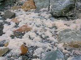 Spume from breaking waves. | |
 Spume Island Location in Antarctica | |
| Geography | |
|---|---|
| Location | Antarctica |
| Coordinates | 64°48′S 64°07′W / 64.800°S 64.117°WCoordinates: 64°48′S 64°07′W / 64.800°S 64.117°W |
| Archipelago | Palmer Archipelago |
| Administration | |
|
None | |
| Demographics | |
| Population | 0 |
| Additional information | |
| Administered under the Antarctic Treaty System | |
Spume Island is a small, low, rocky island lying 2.4 km (1.5 mi) southwest of Bonaparte Point, off the southwest coast of Anvers Island in the Palmer Archipelago. Spume Island is located at 64°48′S 64°07′W / 64.800°S 64.117°W. Spume Island was surveyed by the British Naval Hydrographic Survey Unit, 1956–1957. Spume Island was named by the United Kingdom Antarctic Place-names Committee (UK-APC) because heavy seas break over the island in a gale; spume is blown over it.
See also
- Composite Antarctic Gazetteer
- List of Antarctic and sub-Antarctic islands
- List of Antarctic islands south of 60° S
- SCAR
- Territorial claims in Antarctica
References
External links
| Look up spume in Wiktionary, the free dictionary. |
This article is issued from Wikipedia - version of the 11/12/2016. The text is available under the Creative Commons Attribution/Share Alike but additional terms may apply for the media files.