Oxpens Road
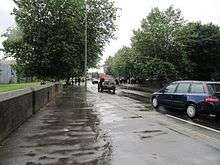 View northwest along Oxpens Road | |
| Length | 0.3 mi (0.5 km) |
|---|---|
| Postal code | OX1 1 |
| Coordinates | 51°44′59″N 1°15′58″W / 51.74972°N 1.26611°W |
| northwest end | Hollybush Row |
| southeast end | Thames Street |
Oxpens Road is a road in central Oxford, England, linking west and south Oxford.[1] It is named after the marshy area of Oxpens,[2] next to one of the branches of the River Thames in Oxford. It forms part of the A420 road.
Locale
To the northwest, Oxpens Road becomes Hollybush Row, meeting at Frideswide Square, forming the major junction of the Botley Road, Park End Street and Hythe Bridge Street near the Saïd Business School and Oxford railway station (to the west of the city centre). To the southeast it becomes Thames Street, just north of the River Thames, and meets the junction with the south end of St Aldates near Christ Church Meadow (to the south of the city centre). It forms part of an inner ring road for the southwest part of the centre of Oxford.
Halfway along is the Oxford Ice Rink, a distinctive 1984 building by Nicholas Grimshaw,[2] which is the home of the Oxford City Stars ice hockey team. One of the campuses of the City of Oxford College is located here on the north side. The road crosses the southern end of the Castle Mill Stream just before it reaches the River Thames. Oxpens Road also provides access to major car parks for the centre of Oxford, including the Westgate Shopping Centre.
History
Before 1850, Oxpens Road was known as Nun's Walk. This area used to be the location of a gasworks by the river.[3]
The locality was one of the poorer quarters of central Oxford. In the 1950s and 1960s there was large-scale clearance of the area, known as The Oxpens. Many residents were moved to Blackbird Leys, an estate consisting largely of council housing on the outskirts of southeast Oxford and close to Morris Motors Limited in Cowley, which provided employment. The area around Oxpens was almost entirely redeveloped during the second half of the 20th century.
Close to Oxpens Road on St Thomas Street was the Morrells Brewery (aka The Lion Brewery), near the Castle Mill Stream, which closed in 1998.[4]
Gallery
-

View southeast along Oxpens Road.
-
_-_geograph.org.uk_-_1571977.jpg)
View northwest along Oxpens Road.
-
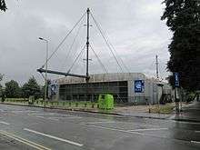
Oxford Ice Rink on Oxpens Road.[1]
-
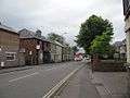
View down Hollybush Row towards Oxpens Road.
-
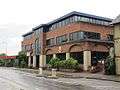
Post office building on Oxpens Road.
- ^ Cite error: The named reference
tyackwas invoked but never defined (see the help page).
See also
| Next crossing upstream | Castle Mill Stream | Next crossing downstream |
| Swan Bridge | Oxpens Road Grid reference: SP509058 |
none |
References
- ↑ Sherwood, Jennifer; Pevsner, Nikolaus (1974). The Buildings of England: Oxfordshire. Penguin Books. pp. 303, 328. ISBN 0-14-071045-0.
- 1 2 Tyack, Geoffrey (1998). Oxford: An architectural guide. Oxford University Press. pp. 334–335. ISBN 0-14-071045-0.
- ↑ "Oxford – Berkshire: 006/03, Ordnance Survey 1:2,500 —Epoch 1". UK: British History Online. 1878. Retrieved 28 December 2012. External link in
|publisher=(help) - ↑ "Morrells Brewery up for Sale". thisisoxfordshire. Newsquest Media Group. 9 July 1998. Archived from the original on December 1, 2008. Retrieved 28 December 2012. External link in
|work=(help)
External links
The City of Oxford | ||
|---|---|---|
| Wards, suburbs, neighbourhoods and districts |
|  |
| Civil parishes | ||
| Former district and borough | ||
| Former constituencies | ||