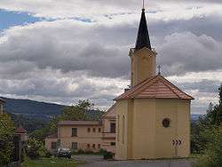
Staňkovice (Litoměřice District)
| Staňkovice | |||
|---|---|---|---|
| Municipality | |||
 | |||
| |||
 Staňkovice | |||
| Coordinates: 50°35′22″N 14°10′0″E / 50.58944°N 14.16667°ECoordinates: 50°35′22″N 14°10′0″E / 50.58944°N 14.16667°E | |||
| Country |
| ||
| Region | Ústí nad Labem | ||
| District | Litoměřice | ||
| Area | |||
| • Total | 2.59 km2 (1.00 sq mi) | ||
| Elevation | 388 m (1,273 ft) | ||
| Population (2008) | |||
| • Total | 36 | ||
| • Density | 14/km2 (36/sq mi) | ||
| Postal code | 412 01 | ||
| Website | http://www.oustankovice.cz | ||
Staňkovice (German Stankowitz) is a village and municipality (obec) in Litoměřice District in the Ústí nad Labem Region of the Czech Republic.
The municipality covers an area of 2.59 square kilometres (1.00 sq mi), and has a population of 58 (as at 1 January 2012).
Staňkovice lies approximately 8 kilometres (5 mi) north-east of Litoměřice, 12 km (7 mi) south-east of Ústí nad Labem, and 59 km (37 mi) north of Prague.
References
| Wikimedia Commons has media related to Staňkovice (Litoměřice District). |
This article is issued from Wikipedia - version of the 4/7/2016. The text is available under the Creative Commons Attribution/Share Alike but additional terms may apply for the media files.