Staffolo
| Staffolo | |
|---|---|
| Comune | |
| Comune di Staffolo | |
 Staffolo Location of Staffolo in Italy | |
| Coordinates: 43°26′N 13°11′E / 43.433°N 13.183°ECoordinates: 43°26′N 13°11′E / 43.433°N 13.183°E | |
| Country | Italy |
| Region | Marche |
| Province / Metropolitan city | Province of Ancona (AN) |
| Area | |
| • Total | 27.6 km2 (10.7 sq mi) |
| Population (Dec. 2004) | |
| • Total | 2,304 |
| • Density | 83/km2 (220/sq mi) |
| Time zone | CET (UTC+1) |
| • Summer (DST) | CEST (UTC+2) |
| Postal code | 60039 |
| Dialing code | 0731 |
Staffolo is a comune (municipality) in the Province of Ancona in the Italian region Marche, located about 35 kilometres (22 mi) southwest of Ancona. As of 31 December 2004, it had a population of 2,304 and an area of 27.6 square kilometres (10.7 sq mi).[1]
Staffolo borders the following municipalities: Apiro, Cingoli, Cupramontana, Jesi, San Paolo di Jesi.
Among the churches in the town are:
- San Francesco
- Chiesa della Madonna della Castellaretta
- Sant'Egidio
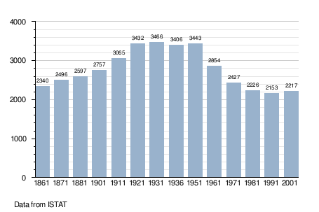
Demographic evolution
Notable people
- Alessandro Costantini, Italian organist and composer, uncle of Vincenzo Albrici and brother of
- Fabio Costantini
References
This article is issued from Wikipedia - version of the 11/24/2016. The text is available under the Creative Commons Attribution/Share Alike but additional terms may apply for the media files.