Oklahoma State Highway 146
| ||||
|---|---|---|---|---|
 | ||||
| Route information | ||||
| Maintained by ODOT | ||||
| Length: | 13.32 mi[1] (21.44 km) | |||
| Existed: | c. 1961 – present | |||
| Major junctions | ||||
| South end: |
| |||
| North end: |
| |||
| Highway system | ||||
| ||||

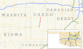
State Highway 146 (abbreviated SH-146) is a short state highway in Caddo County, Oklahoma. It runs for 13.32 miles (21.44 km), connecting State Highway 9 to State Highway 152, at an intersection sometimes known as Three-Way Corner. It provides access to Fort Cobb Lake and Fort Cobb State Park. Along the way it passes through Albert. It has no lettered spur routes.
SH-146 was added to the state highway system around 1961. The highway was established with its present-day routing and has always been paved along the entirety of its route.
Route description
State Highway 146 begins at SH-9 north of Fort Cobb. SH-146 heads due north for one mile (1.6 km) before making a sharp turn to the east. After approximately one-half mile (0.80 km), the highway turns north-northwest, crossing over Cobb Creek, the outlet of Fort Cobb Lake. The highway then resumes a due north course, passing about one mile (1.6 km) east of the lake. After around five miles (8.0 km), the highway makes another ninety-degree turn to due east, returning to due north after approximately three-quarters of a mile (1.21 km). Two miles (3.2 km) north of this curve, the highway passes through Albert, an unincorporated location. SH-146 continues north of Albert for five miles (8.0 km) before reaching Three Way Corner, its junction with SH-152, where it ends.[2]
History
SH-146 first appeared on the 1962 official state map. At this time, the highway followed its present-day route, and its entire length was paved.[3] No changes have been made to the route since 1962.[4]
Junction list
The entire route is in Caddo County.
| Location | mi[1] | km | Destinations | Notes | |
|---|---|---|---|---|---|
| | 0.00 | 0.00 | Southern terminus | ||
| | 13.32 | 21.44 | Northern terminus | ||
| 1.000 mi = 1.609 km; 1.000 km = 0.621 mi | |||||
References
- 1 2 Oklahoma Department of Transportation (2010-01-01). Control Section Maps: Caddo County (PDF) (Map) (2010–2011 ed.). Scale not given. Oklahoma City: Oklahoma Department of Transportation. Retrieved November 12, 2012.
- ↑ Oklahoma Atlas and Gazetteer (Map). 1:200,000. DeLorme. 2006.
- ↑ Oklahoma 1962 (PDF) (Map). Oklahoma Department of Highways. Retrieved February 8, 2013.
- ↑ Official State Map (PDF) (Map) (2013–14 ed.). Oklahoma Department of Transportation. Retrieved February 8, 2013.