State Line, Franklin County, Pennsylvania
| State Line, Franklin County, Pennsylvania | ||
|---|---|---|
| Census-designated place | ||
| ||
 State Line  State Line | ||
| Coordinates: 39°43′21″N 77°43′27″W / 39.72250°N 77.72417°WCoordinates: 39°43′21″N 77°43′27″W / 39.72250°N 77.72417°W | ||
| Country | United States | |
| State | Pennsylvania | |
| County | Franklin | |
| Township | Antrim | |
| Elevation | 710 ft (220 m) | |
| Population (2010) | ||
| • Total | 2,709 | |
| • Density | 989/sq mi (382.0/km2) | |
| Time zone | Eastern (EST) (UTC-5) | |
| • Summer (DST) | EDT (UTC-4) | |
| ZIP code | 17263 | |
| Area code(s) | 717 | |
| FIPS code | 42-73848 | |
| GNIS feature ID | 1217375 | |

State Line is an unincorporated community and census-designated place (CDP) in Antrim Township, Franklin County, Pennsylvania, United States. It is next to the Maryland state line along Interstate 81 and U.S. Route 11 between Hagerstown, Maryland, and Greencastle, Pennsylvania. The ZIP code for State Line, PA is 17263. During the 19th century the village was also known as "Middleburg". As of the 2010 census the population was 2,709.[1]
Statistics
- Median income: $37,741
- Per capita income: $16,316
- Median value of housing units: $175,000
References
- ↑ "Geographic Identifiers: 2010 Census Summary File 1 (G001), State Line CDP, Pennsylvania". American FactFinder. U.S. Census Bureau. Retrieved August 12, 2016.
External links
| Wikimedia Commons has media related to State Line, Franklin County, Pennsylvania. |
- Weather for State Line, PA
- Restaurants near State Line, PA
- Mapquest results for State Line, PA, Franklin County
- http://2010.census.gov/2010census/data/
Municipalities and communities of Franklin County, Pennsylvania, United States | ||
|---|---|---|
| Boroughs | 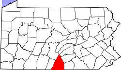 | |
| Townships | ||
| CDPs | ||
| Unincorporated communities | ||
| Footnotes | ‡This populated place also has portions in an adjacent county or counties | |
This article is issued from Wikipedia - version of the 8/12/2016. The text is available under the Creative Commons Attribution/Share Alike but additional terms may apply for the media files.