Indiana State Road 262
| ||||
|---|---|---|---|---|
 | ||||
| Route information | ||||
| Maintained by INDOT | ||||
| Length: | 14.909 mi[1] (23.994 km) | |||
| Existed: | 1932[2] – present | |||
| Major junctions | ||||
| West end: |
| |||
| East end: |
| |||
| Location | ||||
| Counties: | Dearborn, Ohio | |||
| Highway system | ||||
| ||||

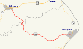
State Road 262 (SR 262) is a state road in the south-eastern section of the state of Indiana. Running for roughly 15 miles (24 km) in a general northwest-southeast direction, it connects the towns of Dillsboro and Rising Sun. SR 262 was originally introduced in the early-1930s routed between along its modern routing. The road was paved in the mid to late 1960s.
Route description
SR 262 begins at US 50 near Dillsboro in Dearborn County. Going south, it crosses SR 62 after only a few hundred feet, then runs southeast. After a few miles, it descends into the Laughery Creek Valley, crossing the creek into Ohio County. After turning eastward and passing through the unincorporated community of Milton, it ascends out of the valley. Both the approach and departure of the valley are fairly hazardous, with sharp curves and steep dropoffs. At about 7 miles, it reaches the top of the ridge, where the road straightens out for a distance of a mile. It then descends into the Arnold Creek Valley, which is also a curvy stretch of road, but less hazardous than the Laughery Creek section. The road enter the town of Rising Sun following Main Street, passing though a residential area of town. SR 262 terminates at an intersection between Main Street and High Street (SR 56) in the town. SR 56 turns onto Main Street for one block, before turning south and continuing towards Vevay and Madison. Indiana Department of Transportation surveys in 2015 showed that the highest traffic levels along SR 262 were the 3,352 vehicles daily in the Rising Sun; the lowest count was 514 vehicles per day in the area of Hartford Pike.[3]
History
The Indiana State Highway Commission designated SR 262 in 1932. The original routing started at US 50 in Dillsboro and ran southeast to SR 56 in Rising Sun much as it does today.[2] The entire route of SR 262 was paved between 1966 and 1967.[4][5] The last major change to SR 262 happen between 1969 and 1970 and it was a short addition north to the new four-lane US 50 in Dillsboro.[6][7] The routing has remained unchanged since[8]
Major intersections
| County | Location | mi[1] | km | Destinations | Notes |
|---|---|---|---|---|---|
| Dearborn | Dillsboro | 0.000 | 0.000 | Western terminus of SR 262 | |
| 0.127 | 0.204 | Eastern terminus of SR 62 | |||
| Ohio | Rising Sun | 14.909 | 23.994 | Eastern terminus of SR 262 | |
| 1.000 mi = 1.609 km; 1.000 km = 0.621 mi | |||||
References
- 1 2 Indiana Department of Transportation (July 2015). Reference Post Book (PDF). Indianapolis: Indiana Department of Transportation. Retrieved October 18, 2016.
- 1 2 "Nearly 1,000 Miles of Roads Absorbed". The Franklin Evening Star. April 22, 1932. p. 5. Retrieved August 25, 2016 – via Newspapers.com.

- ↑ Indiana Department of Transportation (2015). "Traffic Count Database System". Indianapolis: Indiana Department of Transportation. Retrieved November 6, 2016.
- ↑ Indiana State Highway Commission (1966). Indiana State Highway System (Map) (1966–67 ed.). 1:640,000. Indiana State Highway Commission. § L10. OCLC 65209231. Retrieved November 6, 2016 – via Indiana State Library and Historical Bureau.
- ↑ Indiana State Highway Commission (1967). Indiana State Highway System (Map) (1967–68 ed.). 1:640,000. Indiana State Highway Commission. § L10. OCLC 65221593. Retrieved November 6, 2016 – via Indiana State Library and Historical Bureau.
- ↑ Indiana State Highway Commission (1969). Indiana State Highway System (Map). 1:631,000. Indiana State Highway Commission. § L10. OCLC 314731307. Retrieved November 6, 2016 – via Indiana State Library and Historical Bureau.
- ↑ Indiana State Highway Commission (1970). Indiana State Highway System (Map) (1970–71 ed.). 1:640,000. Indiana State Highway Commission. § L10. OCLC 65221477.
- ↑ Indiana Department of Transportation (2016). Indiana Roadway Map 2016 (PDF) (Map). 1:550,000. Indianapolis: Indiana Department of Transportation. § L10. OCLC 925532510. Retrieved November 6, 2016.