Dillsboro, Indiana
| Dillsboro, Indiana | |
|---|---|
| Town | |
|
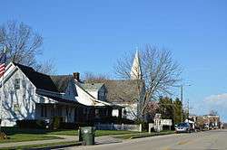
East North Street | |
 Location in the state of Indiana | |
| Coordinates: 39°1′2″N 85°3′32″W / 39.01722°N 85.05889°WCoordinates: 39°1′2″N 85°3′32″W / 39.01722°N 85.05889°W | |
| Country | United States |
| State | Indiana |
| County | Dearborn |
| Township | Clay |
| Area[1] | |
| • Total | 1.00 sq mi (2.59 km2) |
| • Land | 1.00 sq mi (2.59 km2) |
| • Water | 0 sq mi (0 km2) |
| Elevation | 869 ft (265 m) |
| Population (2010)[2] | |
| • Total | 1,327 |
| • Estimate (2012[3]) | 1,327 |
| • Density | 1,327.0/sq mi (512.4/km2) |
| Time zone | EST (UTC-5) |
| • Summer (DST) | EDT (UTC-4) |
| ZIP code | 47018 |
| Area code(s) | 812 |
| FIPS code | 18-18190[4] |
| GNIS feature ID | 0433558[5] |
| Website | http://www.townofdillsboro.com |
Dillsboro is a town in Clay Township, Dearborn County, Indiana, United States. The population was 1,327 at the 2010 census.
History
Dillsboro was laid out in 1830.[6] It was named for James Dill,[7] a general in the War of 1812 and local resident.[8]
The Dillsboro post office, established in 1837, was spelled Dillsborough until 1893.[9]
Geography
Dillsboro is located at 39°01′02″N 85°03′32″W / 39.017095°N 85.058838°W.[10]
According to the 2010 census, Dillsboro has a total area of 1 square mile (2.59 km2), all land.[1]
Climate
The climate in this area is characterized by hot, humid summers and generally mild to cool winters. According to the Köppen Climate Classification system, Dillsboro has a humid subtropical climate, abbreviated "Cfa" on climate maps.[11]
Demographics
| Historical population | |||
|---|---|---|---|
| Census | Pop. | %± | |
| 1880 | 432 | — | |
| 1890 | 439 | 1.6% | |
| 1900 | 465 | 5.9% | |
| 1910 | 425 | −8.6% | |
| 1920 | 471 | 10.8% | |
| 1930 | 502 | 6.6% | |
| 1940 | 558 | 11.2% | |
| 1950 | 681 | 22.0% | |
| 1960 | 745 | 9.4% | |
| 1970 | 840 | 12.8% | |
| 1980 | 1,038 | 23.6% | |
| 1990 | 1,200 | 15.6% | |
| 2000 | 1,436 | 19.7% | |
| 2010 | 1,327 | −7.6% | |
| Est. 2015 | 1,320 | [12] | −0.5% |
2010 census
As of the census[2] of 2010, there were 1,327 people, 520 households, and 320 families residing in the town. The population density was 1,327.0 inhabitants per square mile (512.4/km2). There were 580 housing units at an average density of 580.0 per square mile (223.9/km2). The racial makeup of the town was 98.6% White, 0.2% African American, 0.2% Native American, 0.5% Pacific Islander, and 0.7% from two or more races. Hispanic or Latino of any race were 0.2% of the population.
There were 520 households of which 31.5% had children under the age of 18 living with them, 40.8% were married couples living together, 14.8% had a female householder with no husband present, 6.0% had a male householder with no wife present, and 38.5% were non-families. 34.2% of all households were made up of individuals and 18.6% had someone living alone who was 65 years of age or older. The average household size was 2.34 and the average family size was 2.95.
The median age in the town was 42.2 years. 23.1% of residents were under the age of 18; 6.9% were between the ages of 18 and 24; 24.6% were from 25 to 44; 21.2% were from 45 to 64; and 24.2% were 65 years of age or older. The gender makeup of the town was 44.6% male and 55.4% female.
2000 census
As of the census[4] of 2000, there were 1,436 people, 550 households, and 352 families residing in the town. The population density was 1,421.6 people per square mile (549.0/km²). There were 584 housing units at an average density of 578.1 per square mile (223.3/km²). The racial makeup of the town was 98.19% White, 0.07% African American, 0.21% Native American, 0.14% Asian, 0.14% Pacific Islander, 0.42% from other races, and 0.84% from two or more races. Hispanic or Latino of any race were 1.11% of the population.
There were 550 households out of which 32.9% had children under the age of 18 living with them, 46.5% were married couples living together, 12.7% had a female householder with no husband present, and 36.0% were non-families. 31.1% of all households were made up of individuals and 17.6% had someone living alone who was 65 years of age or older. The average household size was 2.39 and the average family size was 2.99.
In the town the population was spread out with 23.7% under the age of 18, 8.8% from 18 to 24, 24.7% from 25 to 44, 18.5% from 45 to 64, and 24.3% who were 65 years of age or older. The median age was 39 years. For every 100 females there were 81.3 males. For every 100 females age 18 and over, there were 78.8 males.
The median income for a household in the town was $28,462, and the median income for a family was $38,750. Males had a median income of $31,196 versus $21,250 for females. The per capita income for the town was $14,984. About 8.9% of families and 10.5% of the population were below the poverty line, including 11.6% of those under age 18 and 7.6% of those age 65 or over.
Buildings
The Hopewell Presbyterian Church building dates from 1888, although the congregation was formed in 1818 and formally organized in 1828. The building is a classic example of home-based architecture - complete with tiffany glass windows and hand-made pews.
References
- 1 2 "G001 - Geographic Identifiers - 2010 Census Summary File 1". United States Census Bureau. Retrieved 2015-07-16.
- 1 2 "American FactFinder". United States Census Bureau. Retrieved 2012-12-11.
- ↑ "Population Estimates". United States Census Bureau. Retrieved 2013-06-25.
- 1 2 "American FactFinder". United States Census Bureau. Retrieved 2008-01-31.
- ↑ "US Board on Geographic Names". United States Geological Survey. 2007-10-25. Retrieved 2008-01-31.
- ↑ Shaw, Archibald (1915). History of Dearborn County, Indiana: Her People, Industries and Institutions. Unigraphic. p. 165.
- ↑ Gannett, Henry (1905). The Origin of Certain Place Names in the United States. Govt. Print. Off. p. 106.
- ↑ History of Dearborn and Ohio Counties, Indiana: From Their Earliest Settlement, Containing a History of the Counties. Whipporwill Publications. 1885. p. 148.
- ↑ "Dearborn County". Jim Forte Postal History. Retrieved 31 August 2014.
- ↑ "US Gazetteer files: 2010, 2000, and 1990". United States Census Bureau. 2011-02-12. Retrieved 2011-04-23.
- ↑ Climate Summary for Dillsboro, Indiana
- ↑ "Annual Estimates of the Resident Population for Incorporated Places: April 1, 2010 to July 1, 2015". Retrieved July 2, 2016.
- ↑ "Census of Population and Housing". Census.gov. Retrieved June 4, 2015.
External links
Municipalities and communities of Dearborn County, Indiana, United States | ||
|---|---|---|
| Cities | ||
| Towns | ||
| Townships | ||
| CDPs | ||
| Other unincorporated communities | ||