Washington State Route 108
| ||||
|---|---|---|---|---|
| Old Olympic Highway | ||||
|
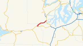
SR 108 highlighted in red. | ||||
| Route information | ||||
| Auxiliary route of US 101 | ||||
| Defined by RCW 47.17.195 | ||||
| Maintained by WSDOT | ||||
| Length: | 11.96 mi[1] (19.25 km) | |||
| Existed: | 1964[2] – present | |||
| Major junctions | ||||
| West end: |
| |||
| East end: |
| |||
| Location | ||||
| Counties: | Grays Harbor, Mason | |||
| Highway system | ||||
| ||||

State Route 108 (SR 108, also known as the Old Olympic Highway)[3] is a state highway in Grays Harbor and Mason counties, of the U.S. state of Washington. It extends 20.67 miles (33.27 km) from SR 8 in the city of McCleary, east to an interchange with U.S. Route 101 (US 101) in Kamilche. The route serves as a bypass and connects McCleary with Shelton, and Port Angeles.
The highway was Secondary State Highway 9D (SSH 9D) from 1937 until 1964, which ran from McCleary to Kamilche. SR 108 was also closed in late October 2008 because of a project to remove a railroad crossing owned by the Puget Sound and Pacific Railroad.
Route description
SR 108 runs 11.96 miles (19.25 km) east from SR 8 in McCleary to an interchange with US 101 in Kamilche. The route serves as a bypass and connects McCleary with Shelton, and Port Angeles.[4][5] WSDOT has found that more than 11,000 motorists utilize the road daily before the interchange with US 101 based on average annual daily traffic (AADT) data.[6]
SR 108 starts at an intersection with SR 8 west of Downtown McCleary. From the intersection, the road briefly goes north before turning east onto Simpson Avenue into Downtown McCleary. Simpson Avenue goes into McCleary and comes to a 3-way intersection with Main Street at Beerbower Park. SR 108 then turns onto Main Street and becomes Summit Road, passing Lake Clara before leaving Downtown McCleary. After passing Hillgrove, the highway enters McCleary Junction and turns northeast to parallel the Puget Sound and Pacific Railroad.[4][7]
At the intersection with Elma Hicklin Road, the road stops paralleling the railroad and continues northeast into Mason County. In Stimson, the railroad starts to parallel the highway, but after that, the railroad curves back, and stops paralleling SR 108. North of Forbes, the highway crosses the railroad and then enters Kamilche,[4] where the road ends at an interchange with US 101.[3]
History

When the Primary and Secondary Highways were formed in 1937, the current SR 108 became Secondary State Highway 9D (SSH 9D).[8] SSH 9D became SR 108 in 1964 during the 1964 highway renumbering, in which the Washington State Department of Transportation (WSDOT) replaced the previous system of Primary and Secondary Highways with a new system called State Routes, which is still in use today.[9][10]
In October 2008, a project to remove an old railroad crossing closed SR 108 for 24 hours near the Little Creek Casino.[11] The railroad crossing was owned by the Puget Sound and Pacific Railroad, currently a division of RailAmerica.[12][13] The railroad crosses SR 108 on its way east from Elma to Shelton.[14][15] The closure caused motorists to use SR 8 and US 101,[11] a 22.54 miles (36.27 km) long detour.[1] The railroad was formerly part of the BNSF Railway.[12]
Major intersections
| County | Location | mi[1] | km | Destinations | Notes |
|---|---|---|---|---|---|
| Grays Harbor | McCleary | 0.000 | 0.000 | ||
| Mason | Kamilche | 11.96 | 19.25 | ||
| 1.000 mi = 1.609 km; 1.000 km = 0.621 mi | |||||
References
- 1 2 3 Washington State Department of Transportation. "State Highway Log, 2006" (pdf). Retrieved November 10, 2008.
- ↑ Washington State Legislature. "RCW 47.17.195: State Route 108". Retrieved November 10, 2008.
- 1 2 Washington State Department of Transportation (May 1, 2007). "SR 101/SR 108/Old Olympic Highway" (PDF). Retrieved November 10, 2008.
- 1 2 3 Google (October 18, 2015). "State Route 108" (Map). Google Maps. Google. Retrieved October 18, 2015.
- ↑ The Road Atlas (Map). Rand McNally. 2008. p. 108. § H5. ISBN 0-528-93961-0.
- ↑ Washington State Department of Transportation (2007). "Washington Annual Average Daily Traffic Data" (PDF). Retrieved November 10, 2008.
- ↑ Official State Highway Map (PDF) (Map) (2008-2009 ed.). 1:842,000. Official State Highway Maps. Cartography by U.S. Geological Survey. Olympia, Washington: Washington State Department of Transportation. 2008. § E2. Retrieved November 10, 2008.
- ↑ Washington State Legislature (1937). "190". Session Laws of the State of Washington. Session Laws of the State of Washington (1937 ed.). Olympia, Washington: Washington State Legislature. Retrieved October 19, 2008.
- ↑ C. G. Prahl, Washington State Highway Commission (December 1, 1965). "Identification of State Highways, Part 1" (PDF).
- ↑ C. G. Prahl, Washington State Highway Commission (December 1, 1965). "Identification of State Highways, Part 2" (PDF).
- 1 2 Murdock, Lisa; Dave Franklin (October 21, 2008). "SR 108 in Mason County closes overnight Friday". Washington State Department of Transportation. Retrieved November 10, 2008.
- 1 2 Department of Computer Science, University of Tennessee (May 2, 2002). "Puget Sound and Pacific Railroad". Retrieved November 10, 2008.
- ↑ Washington State Department of Transportation. "Freight Railroad Contacts". Retrieved November 10, 2008.
- ↑ Puget Sound & Pacific Railroad Operations (Map). Puget Sound and Pacific Railroad. Retrieved November 10, 2008.
- ↑ Washington State Railroad System (PDF) (Map). Cartography by U.S. Geological Survey. Washington State Department of Transportation. 2007. Retrieved November 10, 2008.
External links
Former or proposed State Routes: SR 111 | ||