Shelton, Washington
| Shelton, Washington | |
|---|---|
| City | |
|
Mason County Court House in Shelton, Washington. | |
| Nickname(s): "Christmastown, USA" | |
 Location of Shelton, Washington | |
| Coordinates: 47°12′49″N 123°6′22″W / 47.21361°N 123.10611°WCoordinates: 47°12′49″N 123°6′22″W / 47.21361°N 123.10611°W | |
| Country | United States |
| State | Washington |
| County | Mason |
| Area[1] | |
| • Total | 6.05 sq mi (15.77 km2) |
| • Land | 5.76 sq mi (14.92 km2) |
| • Water | 0.33 sq mi (0.85 km2) |
| Elevation | 23 ft (7 m) |
| Population (2010)[2] | |
| • Total | 9,834 |
| • Estimate (2015)[3] | 9,834 |
| • Density | 1,707.3/sq mi (659.2/km2) |
| Time zone | Pacific (PST) (UTC-8) |
| • Summer (DST) | PDT (UTC-7) |
| ZIP code | 98584 |
| Area code(s) | 360 |
| FIPS code | 53-63735 |
| GNIS feature ID | 1528429[4] |
| Website | City of Shelton |

Shelton is the county seat of Mason County, Washington, United States.[5] Shelton is the westernmost city on Puget Sound. The population was 9,834 at the 2010 census. In terms of population, the city is ranked 161 out of approximately 500 municipalities in Washington. Shelton has a unique form of government in the State of Washington, being the only city in the state which still retains the commission form of government.
History
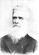
Shelton was officially incorporated in 1890. The city was named after David Shelton, a delegate to the territorial legislature.[6]
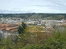
Shelton was once served by a small fleet of steamboats which was part of the Puget Sound Mosquito Fleet. These boats included the Old Settler, Irene, Willie, City of Shelton, Marian, Clara Brown, and S.G. Simpson.[7] The economy was built around logging, farming, dairying and ranching as well as oyster cultivation.[6] The Simpson Timber Company mill on Puget Sound's Oakland Bay dominated the landscape of the downtown area; the mill was sold to Sierra Pacific Industries in 2015, who are currently building a new mill.[8] Shelton also identifies itself as the "Christmas Tree Capital".
Formally incorporated in the 1890s, Shelton's municipal government is run in the Mayor/Commission form.[9] It is the last city in the State of Washington to use this form of government.
Geography
Shelton is located at 47°12′49″N 123°6′22″W / 47.21361°N 123.10611°W (47.213702, −123.106088).[10]
According to the United States Census Bureau, the city has a total area of 6.09 square miles (15.77 km2), of which 5.76 square miles (14.92 km2) is land and 0.33 square miles (0.85 km2) is water.[1]
Climate
Shelton experiences heavy annual precipitation, but experiences a distinct drying trend in summer, in common with much of western Washington. Due to this trend, Shelton's climate is classified as a warm-summer Mediterranean climate (Csb) under the Köppen climate classification system. Temperatures year-round are relatively mild, although extreme highs in summer and extreme lows in winter are not unknown.
| Climate data for Shelton | |||||||||||||
|---|---|---|---|---|---|---|---|---|---|---|---|---|---|
| Month | Jan | Feb | Mar | Apr | May | Jun | Jul | Aug | Sep | Oct | Nov | Dec | Year |
| Record high °F (°C) | 68 (20) |
72 (22) |
76 (24) |
89 (32) |
98 (37) |
102 (39) |
104 (40) |
107 (42) |
99 (37) |
87 (31) |
70 (21) |
66 (19) |
107 (42) |
| Average high °F (°C) | 44.8 (7.1) |
49.1 (9.5) |
53.8 (12.1) |
60.2 (15.7) |
67.4 (19.7) |
72 (22) |
77.3 (25.2) |
77.1 (25.1) |
71.9 (22.2) |
61.2 (16.2) |
50.9 (10.5) |
45.4 (7.4) |
60.9 (16.1) |
| Average low °F (°C) | 32.9 (0.5) |
34.1 (1.2) |
35.6 (2) |
38.8 (3.8) |
44 (7) |
48.8 (9.3) |
52 (11) |
52.2 (11.2) |
48 (9) |
42.2 (5.7) |
37.3 (2.9) |
34.4 (1.3) |
41.7 (5.4) |
| Record low °F (°C) | −2 (−19) |
0 (−18) |
17 (−8) |
22 (−6) |
25 (−4) |
32 (0) |
36 (2) |
34 (1) |
30 (−1) |
22 (−6) |
5 (−15) |
6 (−14) |
−2 (−19) |
| Average precipitation inches (mm) | 10.32 (262.1) |
8.23 (209) |
6.82 (173.2) |
4.2 (107) |
2.29 (58.2) |
1.7 (43) |
0.92 (23.4) |
1.2 (30) |
2.46 (62.5) |
5.79 (147.1) |
9.88 (251) |
11.37 (288.8) |
65.17 (1,655.3) |
| Average snowfall inches (cm) | 4.7 (11.9) |
0.9 (2.3) |
0.6 (1.5) |
0 (0) |
0 (0) |
0 (0) |
0 (0) |
0 (0) |
0 (0) |
0 (0) |
0.9 (2.3) |
1.9 (4.8) |
9 (23) |
| Average precipitation days (≥ 0.01 inch) | 21 | 18 | 19 | 15 | 12 | 9 | 5 | 6 | 9 | 14 | 20 | 22 | 170 |
| Source: [11] | |||||||||||||
Demographics
| Historical population | |||
|---|---|---|---|
| Census | Pop. | %± | |
| 1890 | 648 | — | |
| 1900 | 833 | 28.5% | |
| 1910 | 1,163 | 39.6% | |
| 1920 | 984 | −15.4% | |
| 1930 | 3,091 | 214.1% | |
| 1940 | 3,707 | 19.9% | |
| 1950 | 5,045 | 36.1% | |
| 1960 | 5,651 | 12.0% | |
| 1970 | 6,515 | 15.3% | |
| 1980 | 7,629 | 17.1% | |
| 1990 | 7,241 | −5.1% | |
| 2000 | 8,442 | 16.6% | |
| 2010 | 9,834 | 16.5% | |
| Est. 2015 | 9,834 | [12] | 0.0% |
| U.S. Decennial Census[13] 2015 Estimate[3] | |||
2010 census
As of the census[2] of 2010, there were 9,834 people, 3,574 households, and 2,166 families residing in the city. The population density was 1,707.3 inhabitants per square mile (659.2/km2). There were 3,847 housing units at an average density of 667.9 per square mile (257.9/km2). The racial makeup of the city was 78.9% White, 0.8% African American, 3.7% Native American, 1.1% Asian, 0.8% Pacific Islander, 9.9% from other races, and 4.9% from two or more races. Hispanic or Latino of any race were 19.2% of the population.
There were 3,574 households of which 35.3% had children under the age of 18 living with them, 38.1% were married couples living together, 15.5% had a female householder with no husband present, 6.9% had a male householder with no wife present, and 39.4% were non-families. 31.2% of all households were made up of individuals and 15.6% had someone living alone who was 65 years of age or older. The average household size was 2.63 and the average family size was 3.23.
The median age in the city was 33.1 years. 26.4% of residents were under the age of 18; 10.8% were between the ages of 18 and 24; 26.5% were from 25 to 44; 21.9% were from 45 to 64; and 14.3% were 65 years of age or older. The gender makeup of the city was 49.1% male and 50.9% female.
2000 census
As of the 2000 census, there were 8,442 people, 3,191 households, and 2,035 families residing in the city. The population density was 1,519.4 people per square mile (586.2/km2). There were 3,403 housing units at an average density of 612.5 per square mile (236.3/km2). The racial makeup of the city was 85.83% White, 0.36% African American, 2.72% Native American, 1.17% Asian, 0.73% Pacific Islander, 5.77% from other races, and 3.41% from two or more races. Hispanic or Latino of any race were 10.87% of the population.
There were 3,191 households out of which 32.3% had children under the age of 18 living with them, 44.8% were married couples living together, 13.0% had a female householder with no husband present, and 36.2% were non-families. 29.5% of all households were made up of individuals and 15.5% had someone living alone who was 65 years of age or older. The average household size was 2.52 and the average family size was 3.08.
In the city the population was spread out with 26.7% under the age of 18, 10.0% from 18 to 24, 26.2% from 25 to 44, 19.4% from 45 to 64, and 17.7% who were 65 years of age or older. The median age was 36 years. For every 100 females there were 94.4 males. For every 100 females age 18 and over, there were 89.5 males.
The median income for a household in the city was $32,500, and the median income for a family was $40,392. Males had a median income of $33,867 versus $23,617 for females. The per capita income for the city was $16,303. About 15.3% of families and 18.9% of the population were below the poverty line, including 28.1% of those under age 18 and 6.9% of those age 65 or over.
Notable people
- Desmond "Des" Dalworth Koch – 1956 Olympic bronze medalist, discus[14]
- Jerry Lambert – film and television actor, best known for his work on the ABC sitcom, Sons and Daughters, as well landmark commercials for companies including GEICO, Holiday Inn, and playing a fictional Sony Executive named Kevin Butler[15]
- Justin Ena – former NFL linebacker
- Lawson H. M. Sanderson - Marine Corps aviation pioneer with the rank of Major General
- Karol Kennedy – 5-time national champion and 1952 Winter Olympics silver medalist who competed in the 1948 and 1952 Olympics in pairs figure skating[16]
- Caleb Schlauderaff - NFL offensive lineman
Schools
The Shelton School District is composed of seven schools:[17]
- Evergreen, Mountain View, and Bordeaux Elementary Schools teach kindergarten through fifth grade
- Olympic Middle School teaches sixth and seventh grades
- Oakland Bay Junior High teaches eighth and ninth grades
- Shelton High School covers tenth, eleventh, and twelfth grades
- CHOICE Alternative School teaches kindergarten through twelfth grade
External links
| Wikimedia Commons has media related to Shelton, Washington. |
- City website
- Mason County tourism web site
- Local newspaper
- Local radio station
- City of Shelton circa 1925 (University of Washington collection)
- Washington Corrections Center
References
- 1 2 "US Gazetteer files 2010". United States Census Bureau. Retrieved 2012-12-19.
- 1 2 "American FactFinder". United States Census Bureau. Retrieved 2012-12-19.
- 1 2 "Population Estimates". United States Census Bureau. Retrieved June 29, 2016.
- ↑ "Shelton". Geographic Names Information System. United States Geological Survey.
- ↑ "Find a County". National Association of Counties. Retrieved 2011-06-07.
- 1 2 "City of Shelton – Community". Retrieved February 7, 2008.
- ↑ Newell, Gordon R., Ships of the Inland Sea, at 165–66, Binford and Mort, Portland, OR (2nd Ed. 1960)
- ↑ Sierra Pacific to buy, shut down, then rebuild Shelton Mill
- ↑ http://www.ci.shelton.wa.us/city_commission.php
- ↑ "US Gazetteer files: 2010, 2000, and 1990". United States Census Bureau. 2011-02-12. Retrieved 2011-04-23.
- ↑ "SHELTON, WASHINGTON (457584)". Western Regional Climate Center. Retrieved November 15, 2015.
- ↑ "Annual Estimates of the Resident Population for Incorporated Places: April 1, 2010 to July 1, 2015". Retrieved July 2, 2016.
- ↑ United States Census Bureau. "Census of Population and Housing". Retrieved October 11, 2013.
- ↑ Patch, Steve (January 22, 2004). "2003 Sports Year in Review". Shelton Mason County Journal. Archived from the original on March 27, 2008.
- ↑ IMDb: Jerry Lambert Retrieved on December 7, 2010
- ↑ http://www.sports-reference.com/olympics/athletes/ke/karol-kennedy-1.html
- ↑ "S.S.D. Schools". Archived from the original on May 22, 2009. Retrieved November 4, 2009.
Municipalities and communities of Mason County, Washington, United States | ||
|---|---|---|
| City | 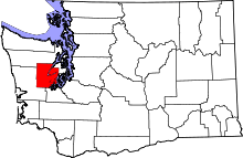 | |
| CDPs | ||
| Other unincorporated communities | ||
| Ghost town | ||
| Indian reservations | ||