Static Peak Divide
| Static Peak Divide | |
|---|---|
|
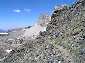
Looking north from Static Peak Divide. Alaska basin is to the left and Grand Teton is in the background at upper right | |
| Elevation | 10,800 ft (3,292 m)[1] |
| Traversed by |
Alaska Basin Trail Death Canyon Trail |
| Location | Teton County, Wyoming, United States |
| Range |
Teton Range, Rocky Mountains |
| Coordinates | 43°41′13.83″N 110°49′45.71″W / 43.6871750°N 110.8293639°W |
| Topo map | USGS Grand Teton, WY |
Static Peak Divide is a pedestrian mountain pass located in the Teton Range, Grand Teton National Park, in the U.S. state of Wyoming.[2] The pass is situated at 10,800 ft (3,300 m) above sea level and is the high point along the Alaska Basin Trail which is accessed from Death Canyon.[1][2] The Static Peak Divide is the highest altitude mountain pass along any maintained trail in Grand Teton National Park and is just west of Static Peak.[3]
References
- 1 2 "Backcountry Camping" (pdf). National Park Service. October 2006. Retrieved 2012-02-18.
- 1 2 Grand Teton, WY (Map). Topoquest (USGS Quads). Retrieved 2012-02-18.
- ↑ Ferguson, Gary (January 1, 1997). Walking Down the Wild: A Journey Through the Yellowstone Rockies. Falcon Guides. p. 173. ISBN 1-56044-575-0. Retrieved 2012-02-18.
This article is issued from Wikipedia - version of the 10/13/2016. The text is available under the Creative Commons Attribution/Share Alike but additional terms may apply for the media files.