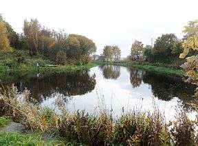
Stockingfield Junction
| Stockingfield Junction | |
|---|---|
|
Stockingfield Junction looking towards Port Dundas | |
| Specifications | |
| Status | Active |
| Navigation authority | Forth and Clyde Canal |
| History | |
| Date completed | 1777 |
| Date closed | 1963 |
| Date restored | 2002 |
Stockingfield Junction (NS571689) is a canal junction which lies in Lambhill, in Glasgow, Scotland. It opened in 1777,[1] and closed in 1963, followed by restoration and a re-opening in 2001-2002.[2] At first a terminus it formed the junction for the Port Dundas branch off the Forth and Clyde Canal main line from 1777.[3][4]
History

The canal from Edinburgh built by John Smeaton first reached Stockingfield in 1775 and due to the lack of funds work halted for two years and Stockingfield Basin and wharf became the terminus of the canal.[5] The canal was filled with water, opening for the transport of goods traffic on 10 November 1775.[6] The branch was completed to Hamiltonhill Basin by November 1777 and to Port Dundas by 1779 upon which date the main line to Bowling was also opened and Stockinfield's status as a junction was completed.[7] The construction of the aqueduct seems to have obliterated the site of the original canal basin and wharf.[8]
Later survey maps of the 19th century show a new building called the Lochburn Road House standing above Stockingfield House on the canal towpath close to the floating bridge that seems to have been used by canal staff involved in the 'opening and closing' of the bridge in relation to the requirements of passing canal traffic.[9] It was demolished by the British Waterways Board in 1958.[10]
The Floating Bridge
A floating bridge at Stockingfield aqueduct once made it possible for the horses pulling the barges to easily and quickly cross over from the 'main line' towpath to the 'branch line' and Bowling towpaths.[11]
The Safety Gates
In 1942 two massive steel safety gates were constructed on the Edinburgh side of Stockingfield Junction at what is known as the Stockingfield Narrows. The purpose of these two hand cranked steel gates was to hold back the waters of the Forth and Clyde Canal to prevent serious flooding in Glasgow in the event of bombing destroying the Stockingfield Aqueduct.[12] A second set of safety or stop locks were also installed in World War II at Firhill and form the Firhill Road Narrows[13] on the Glasgow Branch.[14] and a third set were built at the Craighall Road Narrows near Spiers Wharf. The nearest lock on the Edinburgh main line that could control the water loss after a breach is 17 miles away at Wyndford, Lock 20, whilst the Maryhill Locks 21 to 25 are close by.
Stockingfield or Lochburn Road Aqueduct

Designed in the 1780s by Robert Whitworth and built between 1784 and 1790 the original Stockingfield Aqueduct (NS57126899) and road tunnel arch survive, carrying the main line of the canal over Lochburn Road. At the end of the nineteenth century a ferry operated here for the convenience of pedestrians wishing to cross over to the other towpath to Bowling or to Port Dundas.[15] A floating bridge had also existed here to allow easy access of horses and pedestrians to the towpath on the other side of the canal junction.[16]
The Bigman Bridge
A £4.5 million permanent three way footbridge suspended from the outstretched arms of a 'Big Man' designed by sculptor Andy Scott was planned for installation at Stockingfield Junction.[17][18]
Location
The small estate of Stockingfield gave its name to the canal junction.[19] The Stockingfield Junction lies 4 locks, 20 miles and 4 furlongs to the east of the Union Canal Junction near the Falkirk Wheel. 9 miles, 4 furlongs and 20 locks to the west is the Clyde Canal Junction where the Forth and Clyde Canal reaches the Clyde Estuary at Bowling. The 2 locks and 2 miles and 6½ furlongs to the south is the Port Dundas Basin which was also the terminus of the Monkland Canal.[20]
The Stockingfield Narrows[21] are the pair of 'Safety or Stop' gates built in 1942 to reduce flooding if German bombing hit the Stockingfield or Lochburn Aqueduct No 14.[22]
See also
References
- Notes
- ↑ Hume, p.162
- ↑ Scottish Canals
- ↑ Hume, p.162
- ↑ Waterway Gazetteer - Stockingfield Junction
- ↑ Hume, p.162
- ↑ Visit Scotland - Scottish Canals Walking Guide
- ↑ Hume, p.162
- ↑ Archaeological data Service - Stockingfield Desk Based Assessment
- ↑ Lanarkshire, Sheet VI (includes: Glasgow; Govan; Rutherglen) Survey date: 1858. Publication date: 1865
- ↑ Archaeological data Service - Stockingfield Desk Based Assessment
- ↑ Visit Scotland - Scottish Canals Walking Guide
- ↑ Archaeological data Service - Stockingfield Desk Based Assessment
- ↑ Waterway Gazetteer - Firhill Road Narrows
- ↑ Canmore - Firhill Basin
- ↑ Canmore - Stockingfield Aqueduct
- ↑ Visit Scotland - Scottish Canals Walking Guide
- ↑ Visit Scotland - Scottish Canals Walking Guide
- ↑ Glasgow Canal
- ↑ Archaeological data Service - Stockingfield Desk Based Assessment
- ↑ Waterway Gazetteer- Stockingfield Junction
- ↑ Waterway Gazetteer - Stockingfield Narrows
- ↑ Waterway Gazetteer - Stockingfield Aqueduct
- Sources
- Hume, John R. (1976). The Industrial Archaeology of Scotland. 1. The Lowlands and Borders. London : B.T.Batsford. ISBN 0-7134-3234-9.
External links
- Video footage of the Stockingfield Junction WWII 'Stop or Safety gate'.
- Video footage of Stockingfield Junction.
| Wikimedia Commons has media related to Stockingfield Junction. |
Coordinates: 55°53′33″N 4°17′10″W / 55.89260°N 4.285987°W
