Stonehouse, Plymouth
| Stonehouse | |
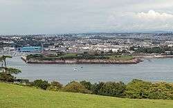 Stonehouse from Mount Edgcumbe |
|
 Stonehouse |
|
| District | Plymouth |
|---|---|
| Shire county | Devon |
| Region | South West |
| Country | England |
| Sovereign state | United Kingdom |
| Post town | Plymouth |
| Postcode district | PL1 3xx |
| Dialling code | 01752 |
| Police | Devon and Cornwall |
| Fire | Devon and Somerset |
| Ambulance | South Western |
| EU Parliament | South West England |
Coordinates: 50°22′15″N 4°09′45″W / 50.370833°N 4.1625°W
East Stonehouse was one of three towns that were amalgamated into modern-day Plymouth. West Stonehouse was a village that is within the current Mount Edgcumbe Country Park in Cornwall. It was destroyed by the French in 1350. The terminology used in this article refers to the settlement of East Stonehouse which is on the Devon side of the mouth of the Tamar estuary, and will be referred to as Stonehouse.
Settlement in the area goes back to Roman times and a house made of stone was believed to have stood near to Stonehouse Creek. However other stories relate to land owned in the 13th century by Robert the Bastard. This land subsequently passed to the Durnford family through marriage to the Edgecombe family in the 14th and 15th centuries. The site of the original settlement of Stonehouse is now mostly occupied by the complex of Princess Yachts. One wall survives as a listed building.
During the 17th, 18th and 19th centuries the areas of Emma Place and Caroline Place were home to many of the west country's top-ranking admirals, doctors and clergy. Those streets together with Millbay Road used to form Plymouth's red light district. Union Street, originally built across marshland, was for almost a century the centre of the city's night life with about a hundred pubs, a music hall and many other attractions. Much of it was destroyed by bombing in World War II. After the war the area between Union Street and the dock has been used by small factories, storage, car dealers and repairers. Since 2002 many of those buildings and yards have been cleared and are being replaced by high density residential buildings.
Notable buildings
Significant buildings include the Royal William Victualling Yard, the Royal Marine Barracks, Stonehouse and the Royal Naval Hospital, Stonehouse. Of these three defence complexes only the Barracks remain in Naval possession, the other two were sold and are now converted to predominantly residential use.
During the reign of Henry VII defences at the mouth of the Tamar were strengthened by the building of cannon-bearing towers. One of these, the Artillery Tower at the sea end of Durnford Street, has been preserved and is now a restaurant.
Two of the surviving buildings close to the dock at Millbay are the red brick Portland stone-faced Georgian assembly room that is still called the Long Room, and the exquisite late Georgian or early Victorian Globe Theatre 300 metres north within the barracks. These were built largely for the pleasures of the officer class and their gentry friends.
On the higher ground towards North Road are two major churches. Firstly the Anglican St Peter's with its tall spire in the centre of Georgian style Wyndham Square. A few hundred metres east is the mid Victorian Roman Catholic cathedral of St Mary and St Boniface (1858). Both buildings have recently been restored with reordered interiors to meet modern liturgical preferences.
During 1882, Arthur Conan Doyle worked as a newly qualified physician at 1 Durnford Street, East Stonehouse. Plaques bearing passages from his works featuring Sherlock Holmes have since been set into the pavement in Durnford Street.[1]
Regeneration
Between 1993 and 1998 the part of Stonehouse to the west of Durnford Street (including the Royal William Victualling Yard) was designated as one of the three areas of the city under control of Plymouth Development Corporation. Gradually affluent residents are moving back into the district which has been comparatively poor since the Great War. Durnford Street is being regentrified. The former Naval Hospital (adjacent to the Millfields – formerly part of Stonehouse Creek) is a gated community with security guards.[2] However, Royal William Yard, also a walled site, welcomes the public freely (apart from car parking charges) to its increasing number of food outlets, and has part of the South West Coast Path running through it, using a staircase specially constructed in 2013. In 2013 a marina was opened within Millbay Docks.[3] Planned post war as a primarily commercial/industrial area the Millbay area of Stonehouse is now perceptibly changing its character. What was a dozen or so years ago viewed as one of the poorest and most deprived areas in north west Europe is fast losing that image.
On Stonehouse Creek, a branch of the Tamar, off the estuary known as the Hamoaze are the modern shipbuilding sheds occupied by the luxury motor-yacht firm Princess Yachts who employ hundreds of local tradesmen to construct and fit out expensive vessels. The creek now ends at Stonehouse Bridge (for many years a toll bridge) and to the north east the wide river bed which led up past Millbridge to Pennycomequick and beyond to the bottom of Ford Park Cemetery, has been reclaimed and infilled to provide the playing fields of Victoria Park, rugby pitches for Devonport High School for Boys, and nearest the bridge a large hardstanding used several days a week for Plymouth's biggest car boot sales. To the north is the main campus of what was Plymouth College of Further Education, now called City College.
Stonehouse is the site of Plymouth's international ferry port at Millbay with at least daily sailings to Roscoff in Brittany (except in winter) and frequent ferries to Santander in northern Spain. Until the 1950s, transatlantic liners would disembark passengers who wished to catch a fast train to London rather than spend another day on board going up the Channel.
There is a regular passenger ferry from the tidal landing Admiral's Hard to Cremyll in Cornwall which is used by visitors to the Mount Edgcumbe Country Park, and commuters to Plymouth.
Notable people
- Alexander Copland Hutchison FRSE surgeon and medical author
- John Eastman Palmer – photographer
- William Eastman Palmer – 19th-century photographer
References
- ↑ "Walk 72 – Plymouth Waterfront Walk". Devon County Council. Retrieved 4 May 2010.
- ↑ "Property details".
- ↑ Plymouth Herald 27 September 2013