Stopče
| Stopče | |
|---|---|
 | |
 Stopče Location in Slovenia | |
| Coordinates: 46°12′55.49″N 15°25′27.66″E / 46.2154139°N 15.4243500°ECoordinates: 46°12′55.49″N 15°25′27.66″E / 46.2154139°N 15.4243500°E | |
| Country |
|
| Traditional region | Styria |
| Statistical region | Savinja |
| Municipality | Šentjur |
| Area | |
| • Total | 0.99 km2 (0.38 sq mi) |
| Elevation | 272.8 m (895.0 ft) |
| Population (2002) | |
| • Total | 255 |
| [1] | |
Stopče (pronounced [ˈstoːptʃɛ]) is a village in the Municipality of Šentjur in eastern Slovenia. It lies on the regional road leading east from Šentjur to Grobelno. The area is part of the historical Styria region. The municipality is now included in the Savinja Statistical Region.[2]
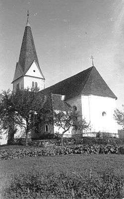
The local church is dedicated to Saint Acacius (Slovene: sveti Ahac) and belongs to the Parish of Šentjur. It dates to 17th century and was extended and vaulted in 1777.[3]
References
External links
- Stopče at Geopedia
 Media related to Stopče at Wikimedia Commons

This article is issued from Wikipedia - version of the 9/22/2016. The text is available under the Creative Commons Attribution/Share Alike but additional terms may apply for the media files.