Strand (island)
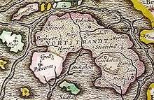
Old Nordstrand (Strand) on a map by Joan Blaeu, 1662. The old shapes of Strand island can still be seen but the majority of the island is marked as submerged.
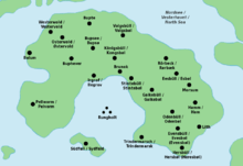
Bilingual map of Strand with German and Danish placenames
Strand was an island on the west coast of Nordfriesland in the Duchy of Schleswig, which was a fiefdom of the Danish crown. Now, the area belongs to Schleswig-Holstein in northern Germany.
The island was formed by the Grote Mandrenke, a huge storm tide that occurred on January 16, 1362. Many villages and towns along the Danish coast, such as Rungholt, were lost. The island of Südfall was separated from the mainland.
In 1634, the Burchardi flood split Strand island into Nordstrand, Pellworm, and Nordstrandischmoor.
References
- Reinhardt, Andreas, ed. (1984). Die erschreckliche Wasser-Fluth 1634 (in German). Husum: Husum Druck- und Verlagsgesellschaft. ISBN 3-88042-257-5.
- "Nordstrander Geschichte" (in German). Municipality of Nordstrand.
| West Frisian Islands (Netherlands) |
|  | |||||||||
|---|---|---|---|---|---|---|---|---|---|---|---|
| East Frisian Islands (Germany) |
| ||||||||||
| Heligoland Bight (Germany) | |||||||||||
| North Frisian Islands (Germany) |
| ||||||||||
| Danish Wadden Sea Islands (Denmark) |
| ||||||||||
Coordinates: 54°32′N 8°47′E / 54.533°N 8.783°E
This article is issued from Wikipedia - version of the 5/23/2015. The text is available under the Creative Commons Attribution/Share Alike but additional terms may apply for the media files.