Rif (island)
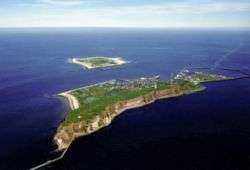
.svg.png) Map of Rif (top) and Engelsmanplaat (bottom) | |
| Geography | |
|---|---|
| Coordinates | 53°27′30″N 6°7′45″E / 53.45833°N 6.12917°ECoordinates: 53°27′30″N 6°7′45″E / 53.45833°N 6.12917°E |
| Archipelago | (West) Frisian Islands |
| Adjacent bodies of water | Wadden Sea, North Sea |
| Administration | |
|
Netherlands | |
| Province | Friesland |
| Municipalities | Dongeradeel and Schiermonnikoog |
| Demographics | |
| Population | Uninhabited |
Rif (Dutch pronunciation: [rɪf]) is a small, uninhabited, Dutch island in the Wadden Sea, lying between Ameland and Schiermonnikoog, north of Engelsmanplaat. It is one of the West Frisian Islands. The island currently has an area of less than 0.1 km². There are no breeding birds to be found, but it is popular as a high tide resting area, for birds as well as seals.
References
External links
-
 Media related to Rif (island) at Wikimedia Commons
| West Frisian Islands (Netherlands) |
|  | |||||||||
|---|---|---|---|---|---|---|---|---|---|---|---|
| East Frisian Islands (Germany) |
| ||||||||||
| Heligoland Bight (Germany) | |||||||||||
| North Frisian Islands (Germany) |
| ||||||||||
| Danish Wadden Sea Islands (Denmark) |
| ||||||||||
This article is issued from Wikipedia - version of the 11/24/2016. The text is available under the Creative Commons Attribution/Share Alike but additional terms may apply for the media files.