Central Islip (LIRR station)
Central Islip | ||||||||||||||||
|---|---|---|---|---|---|---|---|---|---|---|---|---|---|---|---|---|
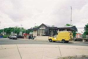 Central Islip Station. Taken on May 22, 2008. | ||||||||||||||||
| Location |
Suffolk Avenue & Lowell Avenue Central Islip, New York | |||||||||||||||
| Coordinates | 40°47′31″N 73°11′41″W / 40.79188°N 73.19467°WCoordinates: 40°47′31″N 73°11′41″W / 40.79188°N 73.19467°W | |||||||||||||||
| Owned by | MTA | |||||||||||||||
| Line(s) | ||||||||||||||||
| Platforms | 2 side platforms | |||||||||||||||
| Tracks | 2 | |||||||||||||||
| Connections |
Lindy's Taxi | |||||||||||||||
| Construction | ||||||||||||||||
| Parking | Yes | |||||||||||||||
| Bicycle facilities | Yes; Bike racks and lockers | |||||||||||||||
| Disabled access | Yes | |||||||||||||||
| Other information | ||||||||||||||||
| Fare zone | 10 | |||||||||||||||
| History | ||||||||||||||||
| Opened | 1987 | |||||||||||||||
| Electrified |
January 18, 1988 750 V (DC) third rail | |||||||||||||||
| Traffic | ||||||||||||||||
| Passengers (2006) | 3,574[1] | |||||||||||||||
| Services | ||||||||||||||||
|
Ticket vending machines
| ||||||||||||||||
Central Islip is a station on the Main Line (Ronkonkoma Branch) of the Long Island Rail Road. It is at the southwest corner of Suffolk County Road 100 (Suffolk Avenue) and Lowell Avenue in Central Islip, New York. Short-term parking is also available on Suffolk CR 100 across from the intersections between Pineville and Hawthorne Avenues.
History
Pre-history; Suffolk Station
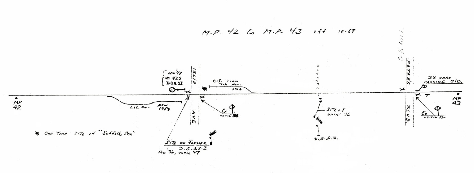
Prior to the opening of Central Islip Station, the LIRR opened Suffolk in the present border between Brentwood and Central Islip on July 14, 1842 on the south side of the track and on the west side of Islip Avenue (now NY 111, then Fifth Avenue).[2] A post office was opened on June 15, 1857, and continued to operate there until to January 7, 1874 when it was transferred to Central Islip. This site was selected by President Fisk of the Long Island Rail Road as the most eligible site for a depot, car house, engine house and well, as long as the land on the north and south sides of the track were handed over. The owner on the north side complied, but the owner on the south side refused, so the idea fell flat. This site was on the main and most travelled route between the Town of Smithtown and Islip. This station was closed as it was replaced by the Central Islip depot that was built further east and opened on November 4, 1873 as a flag stop.[3][4] Rail service in the vicinity didn't die out completely in that area however. A team track and a freight spur were located on the northeast and southwest corners of the railroad crossing until 1959, the southwest spur having been used by the Long Island Lighting Company.[5]
Moving to Central Islip
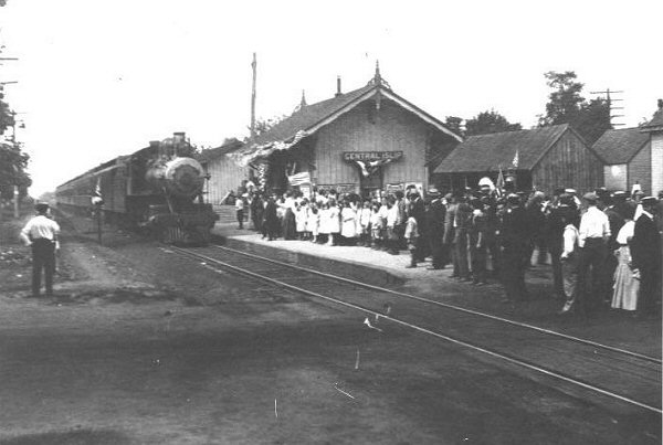
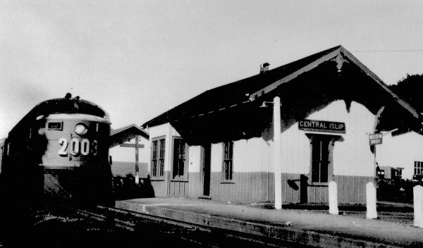
Central Islip station was built between August and October 1873 and opened on November 4, 1873, on the southeast corner of Suffolk County Roads 17 & 100 as a replacement for the former July 14, 1842-built Suffolk station on Islip Avenue (now NY 111, then Fifth Avenue). The condition for getting the depot was that the people had to donate all the land that was needed in addition to $600. The land was deeded over on June 14, 1873 and the $600 paid by July 1, 1873. It was remodeled in 1916 and the original depot was razed in August 1958.[6] On November 16, 1987, it was moved to the corner of Lowell Avenue as part of a major reconstruction of the line in Ronkonkoma, Central Islip, Brentwood, Deer Park, and Wyandanch. The station was built on the site of a former spur to the Central Islip Psychiatric Center, including the hospital's power plant that was abandoned years before the hospital was closed.[7] Across Lowell Avenue is the site of a Waldbaum's warehouse that once had a freight spur leading to it. The site of the 1958-built station was used as an MTA Police station until that was moved to a larger facility across Suffolk CR 17.
Central Islip Hospital Station
Central Islip State Hospital originally had two railroad spurs from the team track east of the former site of Central Islip Station, although not necessarily used simultaneously. One which ran along what is today Audwin Road and curved southwest through Carleton Avenue and South Research Place was for passengers, patients, and visitors, and the other along Lowell Avenue was for freight, which by 1950 was used fuel the power plant at the station, and a state-run warehouse.[8] The switching locomotives contained markings exclusively for the hospital, rather than the LIRR.
With medication, de-institutionalization, and social reforms that reduced the criteria for committing people, the use of rail service at the hospital was gradually reduced. The station house was moved from the Audwin Road spur to the Lowell Road Spur, around 1966. Passenger service was eliminated by 1971,[9] and rail service was reduced to freight only. The Lowell Avenue spur was neglected through the years until it was finally demolished before the station was moved from Carleton Avenue in 1987.
Platforms and tracks
| A | ■ Ronkonkoma Branch | toward New York (Brentwood) |
| ■ Ronkonkoma Branch | toward Ronkonkoma (Terminus) | |
| B | ■ Ronkonkoma Branch | toward New York (Brentwood) |
| ■ Ronkonkoma Branch | toward Ronkonkoma (Terminus) |
The station has two high-level side platforms, each 12 cars long. The north platform is next to the siding track, while the south platform is next to the main track. Most trains on weekdays and all trains at all times serve Platform B, and a few weekday trains serve Platform A.
References
- ↑ Average weekday, 2006 LIRR Origin and Destination Study
- ↑ Earliest stations of the LIRR (Unofficial Long Island Rail Road History Website)
- ↑ Seyfried, Vincent F. "The Long Island Rail Road, a comprehensive history. ... v.3. - Full View - HathiTrust Digital Library - HathiTrust Digital Library". hathitrust.org.
- ↑ "LONG ISLAND STATION HISTORY". trainsarefun.com.
- ↑ Bob Emery map of Central Islip MP42-43 October, 1957 (TrainsAreFun)
- ↑ 1958-built former Central Islip Station (Existing Railroad Stations in Suffolk County, New York)
- ↑ Central Islip State Hospital Railroad Spur (Arrt's Arrchives)
- ↑ CISH Rail Spur (LIRR Oddities)
- ↑ The State Hospitals in Suffolk County, New York and the Long Island Rail Road (Arrt's Arrchive)
External links
- Official LIRR station information page for Central Islip
- Station timetable for Central Islip
- Photo of Central Islip Station from the parking lot (Unofficial LIRR History Website)
- Central Islip Station; 1910 and 1957 (TrainsAreFun.com)
- Unofficial LIRR Photography Site (lirrpics.com)
- CI Interlocking (The LIRR Today)
- Station from Lowell Avenue from Google Maps Street View