Sukabumi Regency
| Sukabumi Regency Kabupaten Sukabumi | ||||||
|---|---|---|---|---|---|---|
| Regency | ||||||
| Other transcription(s) | ||||||
| • Sundanese | ᮊᮘᮥᮕᮒᮦᮔ᮪ ᮞᮥᮊᮘᮥᮙᮤ | |||||
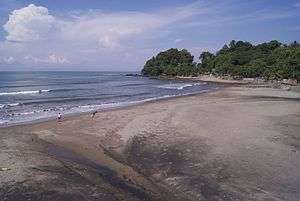
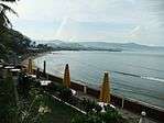
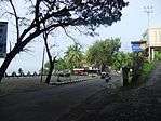
Clockwise, from top left : Karanghawu Beach, Streetscape of Pelabuhan Ratu, Cikaso waterfall, Pelabuhan Ratu Bay | ||||||
| ||||||
| Motto: Gemah Ripah Loh Jinawi | ||||||
 Sukabumi Regency Location of Sukabumi Regency in Indonesia | ||||||
| Coordinates: 6°55′S 106°55′E / 6.917°S 106.917°E | ||||||
| Country | Indonesia | |||||
| Province | West Java | |||||
| Government | ||||||
| • Regent | Drs. H. Sukmawijaya, MM | |||||
| Area | ||||||
| • Total | 4,145.70 km2 (1,600.66 sq mi) | |||||
| Population (2014) | ||||||
| • Total | 2,517,982 | |||||
| Time zone | WIB (UTC+7) | |||||
| Area code(s) | 0266 | |||||
| Website | http://www.kabupatensukabumi.go.id | |||||
Sukabumi Regency Indonesian: Kabupaten Sukabumi is a regency (kabupaten) in the West Java Province, Indonesia. The regency seat is located in Pelabuhan Ratu, a coastal city facing the Indian Ocean. The regency fully encircles the administratively separated city of Sukabumi. The regency is the second largest regency by area in Java after the Banyuwangi Regency in East Java.
The regency covered an area of 4,145.70 km2, the largest in West Java, and has a population of 2,341,409 at the 2010 Census. The bulk of the regency's population of 2,517,982 (in January 2014) lives in the northeastern part of the regency that encircles Sukabumi City and Mount Gede. A plan to create a new regency, the North Sukabumi Regency is currently waiting for the approval of the central government.[1]
History
Formation
The regency was originally carved out from the colonial era-Tjianjoer Regency. It was then part of the Priangan Residency (Residentie Preanger Regentschappen). In 1776, the regent of Tjianjoer Raden Adipati Wira Tanu Datar VI created a kepatihan (viceregency) named Tjikole Viceregency consisted the districts of Goenoengparang, Tjimahi, Tjiheoelang, Tjitjoeroeg, Djampangtengah and Djampangkoelon with its seat in Tjikole (now part of Sukabumi).
On January 13, 1815, the Tjikole Vice regency renamed as Soekaboemi Viceregency. The name Soekaboemi was proposed by a Dutch surgeon and plantation owner named Dr. Andries de Wilde, who resided in the viceregency. The origin of the name came from the combination of two Sanskrit words, Soeka (happiness, likely) and Boemi (earth, land). Thus Soekaboemi could be translated as "Likable Land".
Geography
Beaches
Along the southern coast of the regency there are several beaches such as Pasir Putih Beach (Cipanarikan estuary), Pangumbahan Beach (also known as Turtle Beach), Cibuaya Beach and Ujunggenteng Beach. Batununggul Beach is suitable for surfing with average wave height approximately 3 meters in dry season, but only 1 meter in rainy season.[2]
Waterfalls
The 120-meters Caweni Waterfall is located only 200 metres from Cidolog road, about 70 kilometres south of Sukabumi and about 25 kilometres from Sagaranten District.[3]
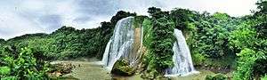
The Cikaso Waterfall (Ciniti Waterfall) is located in Jampang Kulon district, 1.5 hours drive (70 kilometres) from Sukabumi City. The waterfall height is 80 metres; it consists of 3 waterfalls, from left to right Asepan Waterfall, Meong Waterfall and Aki Waterfall.[4]
Culture
Traditional festivities
The local people hold the Ocean Fiesta every year on 5 April in Pelabuhan Ratu Beach. There is also Ngabungbang tradition in Cisukawayana river estuary on every full moon of each month in early morning. Ngabungbang or Mass ritual bath is a pre-Islamic tradition since 175-205 BC when King Hyang Brahma ruled Medang Gali (Galuh) Kingdom and continued by Prabu Siliwangi from Sunda Kingdom until now.[5]
Administrative divisions
Until 2014, Sukabumi Regency was divided into 47 districts (kecamatan), listed below with their populations at the 2010 Census.[6] These exclude the further seven districts which are within the city of Sukabumi (and thus administratively outside the regency).
|
|
|
|
The proposed creation of a new North Sukabumi Regency (Kabupaten Sukabumi Utara) will comprise 23 of the above districts of Sukabumi Regency.
References
- ↑ Dana Pemekaran Terancam Batal
- ↑ Batununggul Beach
- ↑ Caweni Waterfall
- ↑ "Pesona Air Terjun Curug Cikaso". May 21, 2012.
- ↑ "Pelabuhan Ratu, Sukabumi Pantai dengan Panorama Indah nan Mistis". October 12, 2012.
- ↑ Biro Pusat Statistik, Jakarta, 2011.
External links
Coordinates: 6°55′11″S 106°55′38″E / 6.91972°S 106.92722°E