Supervolcano
A supervolcano is a volcano capable of producing a volcanic eruption with an ejecta mass greater than 1015 kg (1012 t).[1] Supervolcanoes occur when magma in the mantle rises into the crust but is unable to break through the crust, and pressure builds in a large and growing magma pool until the crust is unable to contain the pressure. This can occur at hotspots (for example, Yellowstone Caldera) or at subduction zones (for example, Toba). Another setting for the eruption of very large amounts of volcanic material is in large igneous provinces, which can cover huge areas with lava and volcanic ash, causing long-lasting climate change (such as the triggering of a small ice age or global warming), which can threaten species with extinction. The Oruanui eruption of New Zealand's Taupo Volcano, the world's most recent supereruption, had a Volcanic Explosivity Index of 8.
Terminology
The origin of the term supervolcano is linked to an early 20th-century scientific debate about the geological history and features of the Three Sisters volcanic region of Oregon in the United States. In 1925, Edwin T. Hodge suggested that a very large volcano, which he named Mount Multnomah, had existed in that region. He believed that several peaks in the Three Sisters area are the remnants left after Mount Multnomah had been largely destroyed by violent volcanic explosions, similar to Mount Mazama.[2] In 1948, the possible existence of Mount Multnomah was ignored by volcanologist Howel Williams in his book The Ancient Volcanoes of Oregon. The book was reviewed in 1949 by another volcanologist, F. M. Byers Jr.[3] In the review, Byers refers to Mount Multnomah as a supervolcano.[4] Although Hodge's suggestion that Mount Multnomah is a supervolcano was rejected long ago, the term supervolcano was popularised by the BBC popular science television program Horizon in 2000 to refer to eruptions that produce extremely large amounts of ejecta.[5][6]
Volcanologists and geologists do not refer to "supervolcanoes" in their scientific work, since this is a blanket term that can be applied to a number of different geological settings. Since about 2000, however, the term has been used by professionals for communicating science to the public. The term megacaldera is sometimes used for caldera supervolcanoes, such as the Blake River Megacaldera Complex in the Abitibi greenstone belt of Ontario and Quebec, Canada. Eruptions that rate VEI 8 are termed super eruptions.[7] Though there is no well-defined minimum explosive size for a "supervolcano", there are at least two types of volcanic eruptions that have been identified as supervolcanoes: large igneous provinces and massive eruptions.[1]
Large igneous provinces
Large igneous provinces (LIP) such as Iceland, the Siberian Traps, Deccan Traps, and the Ontong Java Plateau are extensive regions of basalts on a continental scale resulting from flood basalt eruptions. When created, these regions often occupy several thousand square kilometres and have volumes on the order of millions of cubic kilometers. In most cases, the lavas are normally laid down over several million years. They release large amounts of gases. The Réunion hotspot produced the Deccan Traps about 66 million years ago, coincident with the Cretaceous–Paleogene extinction event. The scientific consensus is that a meteor impact was the cause of the extinction event, but the volcanic activity may have caused environmental stresses on extant species up to the Cretaceous–Paleogene boundary.[8] Additionally, the largest flood basalt event (the Siberian Traps) occurred around 250 million years ago and was coincident with the largest mass extinction in history, the Permian–Triassic extinction event, although it is also unknown whether it was completely responsible for the extinction event.
Such outpourings are not explosive, though lava fountains may occur. Many volcanologists consider that Iceland may be a LIP that is currently being formed. The last major outpouring occurred in 1783–84 from the Laki fissure which is approximately 40 km (25 mi) long. An estimated 14 km3 (3.4 cu mi) of basaltic lava was poured out during the eruption.
The Ontong Java Plateau now has an area of about 2,000,000 km2 (770,000 sq mi), and the province was at least 50% larger before the Manihiki and Hikurangi Plateaus broke away.
Massive explosive eruptions
Volcanic eruptions are classified using the Volcanic Explosivity Index, or VEI. It is a logarithmic scale, which means that an increase of one in VEI number is equivalent to a tenfold increase in volume of erupted material. VEI 7 or VEI 8 eruptions are so powerful that they often form circular calderas rather than cones because the downward withdrawal of magma causes the overlying rock mass to collapse into the empty magma chamber beneath it.
VEI 8 eruptions are colossal events that throw out at least 1,000 km3 (240 cu mi) bulk volume.
VEI 7 events eject bulk volume at least 100 km3 (24 cu mi).
VEI 6 eruptions occurred at Krakatoa in 1883 and Mount Pinatubo in 1991. These eruptions ejected ~10 and 25 km3 (2.4 and 6.0 cu mi) bulk volume, respectively. At Krakatoa, the Dutch colonial authorities claimed that the death toll was 36,417, but other estimates consider that the death toll is in excess of 120,000.
The 1980 Mount St. Helens eruption was a VEI 5 eruption, with 1.2 km3 (0.29 cu mi) bulk volume of ejecta.
Known supereruptions

VEI 8
| Name | Zone | Location | Notes | Years ago (approx.) | Ejecta bulk volume (approx.) | Reference |
|---|---|---|---|---|---|---|
| La Garita Caldera | San Juan volcanic field | U.S., Colorado | Fish Canyon eruption. | 27,800,000 | 5,000 km³ | |
| Lake Toba | Lake Toba | Indonesia, Sumatra | Produced 2200-4400 tons of H2SO4. | 74,000 | 2,800 km³ | [9][10][11][12][13] |
| Huckleberry Ridge eruption | Yellowstone hotspot | U.S., Idaho/Wyoming | Huckleberry Ridge Tuff | 2,100,000 | 2,500 km³ | [14] |
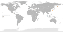
| Atana Ignimbrite | Pacana Caldera | Chile, Northern | Part of the Altiplano–Puna volcanic complex | 4,000,000 | 2,500 km³ | [15] |
| Whakamaru | Taupo Volcanic Zone | New Zealand, North Island | Whakamaru Ignimbrite/Mount Curl Tephra | 340,000 | 2,000 km³ | [16] |
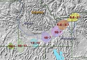
| Heise Volcanic Field | Yellowstone hotspot | U.S., Idaho | Kilgore Tuff | 4,500,000 | 1,800 km³. | [17] |
| Heise Volcanic Field | Yellowstone hotspot | U.S., Idaho | Blacktail Tuff | 6,000,000 | 1,500 km³. | [17] |
| Cerro Guacha | Altiplano-Puna volcanic complex | Bolivia | Guacha ignimbrite, two smaller eruptions identified | 5,700,000 | 1,300 km³. | [18] |
| Oruanui eruption | Taupo Volcanic Zone | New Zealand, North Island | Taupo Volcano (Lake Taupo) | 26,500 | 1,170 km³ | |
| Cerro Galán | Andes Central Volcanic Zone | Argentina, Catamarca Province | 2,500,000 | 1,050 km³ | ||
| Lava Creek eruption | Yellowstone hotspot | U.S., Wyoming | Lava Creek Tuff | 640,000 | 1,000 km³ | [14] |
Based on incomplete statistics, at least 60 VEI 8 eruptions have been identified.[1][19]
VEI 7
VEI 7 eruptions, less colossal but still supermassive, have occurred in historical times. The only ones in the past 2,000 years are Tambora, in 1815,[20] Taupo Volcano's Hatepe eruption, c. 232,[21] Baekdu Mountain, in 946–47,[22] and the eruption of Mount Samalas in 1257.[23]
| Name | Zone | Location | Event / notes | Years ago prior to 1950 (Approx.) | Ejecta volume (Approx.) |
|---|---|---|---|---|---|
| Mount Tambora | Sumbawa Island, West Nusa Tenggara | Indonesia | This eruption took place in 1815. 1816 became known as the Year Without a Summer. | 135 | 120 km³ |
| Baekdu Mountain | Control by Baikal Rift Zone | China/North Korea | One of the largest volcanic eruptions in the past 2000 years. Millennium Eruption. | 1,004 | 100–120 km³ |
| Taupo Volcano (Lake Taupo) | Taupo Volcanic Zone | New Zealand, North Island | Hatepe eruption AD 232 | 1,718 | 120 km³ [21] |
| Kikai Caldera | Japan, Ryukyu Islands | Kikai Caldera 4,300 BC |
6,300 | 150 km³ | |
| Macauley Island | Kermadec Islands | New Zealand | Macauley Island 8,300 to 6,300 years ago | 6,300 | 100 km³ [24][25] |
| Kurile Lake | Kamchatka Peninsula | Russia | Kurile Lake 6,440 BC |
10,500 | 140–170 km³ [26] |
| Aira Caldera | Japan, Kyūshū | Aira Caldera | 22,000 | 450 km³ | |
| Rotoiti Ignimbrite | Taupo Volcanic Zone | New Zealand, North Island | Rotoiti Ignimbrite | 50,000 | 240 km³ [27] |
| Campi Flegrei | Italy, Naples | 39,000 | 84 km³* | ||
| Mount Aso | Japan, Kyūshū | Four large explosive eruptions between 300,000 and 80,000 years ago. | 300,000 | 600 km³ | |
| Reporoa Caldera | Taupo Volcanic Zone | New Zealand, North Island | 230,000 | 100 km³ [28] | |
| Mamaku Ignimbrite | Taupo Volcanic Zone | New Zealand, North Island | Rotorua Caldera | 240,000 | 280 km³ [29] |
| Matahina Ignimbrite | Taupo Volcanic Zone | New Zealand, North Island | Haroharo Caldera | 280,000 | 120 km³ [30] |
| Long Valley Caldera | Bishop Tuff | U.S., California | 760,000 | 600 km³ | |
| Valles Caldera | Jemez volcanic field | U.S., New Mexico | Two eruptions at 1.15 and 1.47 million years ago | 1,150,000 [31] |
600 km³ [31] |
| Mangakino | Taupo Volcanic Zone | New Zealand, North Island | Three eruptions from 0.97 to 1.23 million years ago | 970,000 | 300 km³ [32] |
| Henry's Fork Caldera | Yellowstone hotspot Mesa Falls Tuff |
U.S., Idaho | Yellowstone hotspot | 1,300,000 | 280 km³ [14] |
| Karymshina | Kamchatka | Russia | 1,780,000 [33] |
>1000 km³ [34] | |
| Pastos Grandes Ignimbrite | Pastos Grandes Caldera | Bolivia | 2,900,000 | 820 km³ [35] | |
| Heise volcanic field | Yellowstone hotspot Walcott Tuff |
U.S., Idaho | Yellowstone hotspot | 6,400,000 | 750 km³ [17] |
| Bruneau-Jarbidge caldera | Yellowstone hotspot | U.S., Idaho | Yellowstone hotspot Responsible for the Ashfall Fossil Beds 1,600 km to the east[36] |
6,710,000[37] | 950 km³ [38] |
| Cerro Panizos | Altiplano-Puna volcanic complex | Argentina, Bolivia | 12,000,000 | 250 km³ | |
| Bennett Lake Volcanic Complex | Skukum Group | Canada, British Columbia/Yukon | 50,000,000 | 850 km³ [39] |
* means DRE (dense rock equivalent).
Media portrayal
- In 2004, Naked Science TV show aired supervolcano on National Geographic Channel.
- In 2005, a two-part television disaster film called Supervolcano aired on BBC One, the Discovery Channel, and other television networks worldwide.
- Nova featured an episode Mystery of the Megavolcano in September 2006 examining such eruptions in the last 100,000 years.[40]
- In 2006, the Sci Fi Channel aired the documentary Countdown to Doomsday which featured a segment called "Supervolcano". The same year, ABC News aired the documentary Last Days on Earth, which featured a segment called "Supervolcano".
- Also in 2006, the Syfy Channel series Stargate Atlantis episode entitled "Inferno" featured a supervolcano as the major plot device. Dr. Rodney McKay, one of the main characters, uses Yellowstone National Park to describe what a supervolcano is.
- In the episode "Humanity" of the television drama Young Justice, the team must relieve the pressure of the Yellowstone Caldera supervolcano caused by Red Volcano before an eruption with the potential for mass extinction takes place.
- In 2009, the apocalypse-themed film 2012 featured the super-eruption of the massive Yellowstone Caldera, a result of the Earth's core heating up. This made most of the United States uninhabitable.
- In 2010, the SyFy series Warehouse 13 featured an episode entitled Reset in which a supervolcano, specifically the Yellowstone Caldera, plays an important role.
- In December 2011, author Harry Turtledove published Supervolcano: Eruption, the first of a planned four-novel series about events leading up to and following a fictional eruption of the Yellowstone Caldera. The second book in the series, Supervolcano: All Fall Down, was published in December 2012. The third book Supervolcano: Things Fall Apart, was published in December 2013.
- At the end of Terry Pratchett and Stephen Baxter's novel Long War the Yellowstone Caldera erupts. The aftermath is featured in the next volume, Long Mars.
- The Siberian Traps and Lake Toba were featured in Animal Planet's prehistoric documentary Animal Armageddon (each in one episode), where speculation of the lifeforms they afflicted were brought to life.
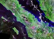
 Satellite image of San Salvador, El Salvador and the Lake Ilopango caldera (also known as the Dark Age volcano) in the Valley of the Hammocks, site of a VEI 6-8 eruption and said to be ground zero for the extreme weather events of 535–536, when a dark veil settled on the world.
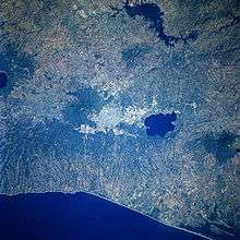
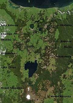 Volcano, lake, and caldera locations in the Taupo Volcanic Zone
See also
References
- 1 2 3 Bryan, S.E. (2010). "The largest volcanic eruptions on Earth". Earth-Science Reviews. doi:10.1016/j.earscirev.2010.07.001.
- ↑ Harris, Stephen (1988) Fire Mountains of the West: The Cascade and Mono Lake Volcanoes, Missoula, Mountain Press.
- ↑ Byers, Jr., F. M. (1949) Reviews: The Ancient Volcanoes of Oregon by Howel Williams, The Journal of Geology, volume 57, number 3, May 1949, page 324. Retrieved 2012-08-17.
- ↑ supervolcano, n. Oxford English Dictionary, third edition, online version June 2012. Retrieved on 2012-08-17.
- ↑ Supervolcanoes. Bbc.co.uk (2000-02-03). Retrieved on 2011-11-18.
- ↑ USGS Cascades Volcano Observatory. Vulcan.wr.usgs.gov. Retrieved on 2011-11-18.
- ↑ de Silva, Shanaka (2008). "Arc magmatism, calderas, and supervolcanos". Geology. 36 (8): 671–672. doi:10.1130/focus082008.1.
- ↑ Keller, G (2014). "Deccan volcanism, the Chicxulub impact, and the end-Cretaceous mass extinction: Coincidence? Cause and effect?". Geological Society of America Special Papers. doi:10.1130/2014.2505(03).
- ↑ Petraglia, M.; Korisettar, R.; Boivin, N.; Clarkson, C.; Ditchfield, P.; Jones, S.; Koshy, J.; Lahr, M. M.; et al. (2007). "Middle Paleolithic Assemblages from the Indian Subcontinent Before and After the Toba Super-Eruption". Science. 317 (5834): 114–6. Bibcode:2007Sci...317..114P. doi:10.1126/science.1141564. PMID 17615356.
- ↑ Knight, M.D., Walker, G.P.L., Ellwood, B.B., and Diehl, J.F. (1986). "Stratigraphy, paleomagnetism, and magnetic fabric of the Toba Tuffs: Constraints on their sources and eruptive styles". Journal of Geophysical Research. 91: 10355–10382. Bibcode:1986JGR....9110355K. doi:10.1029/JB091iB10p10355.
- ↑ Ninkovich, D., Sparks, R.S.J., and Ledbetter, M.T. (1978). "The exceptional magnitude and intensity of the Toba eruption, Sumatra: An example of using deep-sea tephra layers as a geological tool". Bulletin Volcanologique. 41 (3): 286–298. Bibcode:1978BVol...41..286N. doi:10.1007/BF02597228.
- ↑ Rose, W.I. & Chesner, C.A. (1987). "Dispersal of ash in the great Toba eruption, 75 ka" (PDF). Geology. 15 (10): 913–917. Bibcode:1987Geo....15..913R. doi:10.1130/0091-7613(1987)15<913:DOAITG>2.0.CO;2. ISSN 0091-7613.; Lee Siebert, Tom Simkin, Paul Kimberly Volcanoes of the World. University of California Press, 2011 ISBN 0-520-26877-6
- ↑ Williams, M.A.J. & Royce, K. (1982). "Quaternary geology of the middle son valley, North Central India: Implications for prehistoric archaeology". Palaeogeography, Palaeoclimatology, Palaeoecology. 38 (3–4): 139. doi:10.1016/0031-0182(82)90001-3.
- 1 2 3 Global Volcanism Program | Volcanoes of the World | Large Holocene Eruptions. Volcano.si.edu. Retrieved on 2011-11-18.
- ↑ Lindsay, J. M.; de Silva, S.; Trumbull, R.; Emmermann, R.; Wemmer, K. (2001). "La Pacana caldera, N. Chile: a re-evaluation of the stratigraphy and volcanology of one of the world's largest resurgent calderas". Journal of Volcanology and Geothermal Research. 106 (1–2): 145–173. Bibcode:2001JVGR..106..145L. doi:10.1016/S0377-0273(00)00270-5.
- ↑ Froggatt, P. C.; Nelson, C. S.; Carter, L.; Griggs, G.; Black, K. P. (13 February 1986). "An exceptionally large late Quaternary eruption from New Zealand". Nature. 319 (6054): 578–582. Bibcode:1986Natur.319..578F. doi:10.1038/319578a0.
The minimum total volume of tephra is 1,200 km³ but probably nearer 2,000 km³, ...
- 1 2 3 Lisa A. Morgan & William C. McIntosh (2005). "Timing and development of the Heise volcanic field, Snake River Plain, Idaho, western USA". GSA Bulletin. 117 (3–4): 288–306. Bibcode:2005GSAB..117..288M. doi:10.1130/B25519.1.
- ↑ Salisbury, M. J.; Jicha, B. R.; de Silva, S. L.; Singer, B. S.; Jimenez, N. C.; Ort, M. H. (21 December 2010). "40Ar/39Ar chronostratigraphy of Altiplano-Puna volcanic complex ignimbrites reveals the development of a major magmatic province". Geological Society of America Bulletin. 123 (5-6): 821–840. doi:10.1130/B30280.1. Retrieved 29 November 2015.
- ↑ BG, Mason (2004). "The size and frequency of the largest explosive eruptions on Earth". Bull Volcanol. doi:10.1007/s00445-004-0355-9.
- ↑ Oppenheimer, Clive (2003). "Climatic, environmental and human consequences of the largest known historic eruption: Tambora volcano (Indonesia) 1815". Progress in Physical Geography. 27 (2): 230–259. doi:10.1191/0309133303pp379ra.
- 1 2 Hogg, A (2011). "Revised calendar date for the Taupo eruption derived by 14C wiggle-matching using a New Zealand kauri 14C calibration data set". The Holocene. doi:10.1177/0959683611425551.
- ↑ Xu, JD (2013). "Climatic impact of the Millennium eruption of Changbaishan volcano in China: New insights from high-precision radiocarbon wiggle-match dating". Geophysical Research Letters. doi:10.1029/2012GL054246.
- ↑ Vidal, CM (2015). "Dynamics of the major plinian eruption of Samalas in 1257 A.D. (Lombok, Indonesia)". Bull Volcanol. doi:10.1007/s00445-015-0960-9.
- ↑ Latter, J. H.; Lloyd, E. F.; Smith, I. E. M.; Nathan, S. 1992. Volcanic hazards in the Kermadec Islands and at submarine volcanoes between southern Tonga and New Zealand, Volcanic hazards information series 4. Wellington, New Zealand. Ministry of Civil Defence. 44 p.
- ↑ "Macauley Island". Global Volcanism Program. Smithsonian Institution.
- ↑ Kurile Lake on the Global Volcanism Program
- ↑ Froggatt, P. C. & Lowe, D. J. (1990). "A review of late Quaternary silicic and some other tephra formations from New Zealand: their stratigraphy, nomenclature, distribution, volume, and age". New Zealand Journal of Geology and Geophysics. 33: 89–109. doi:10.1080/00288306.1990.10427576.
- ↑ I. A. Nairn; C. P. Wood; R. A. Bailey (December 1994). "The Reporoa Caldera, Taupo Volcanic Zone: source of the Kaingaroa Ignimbrites". Bulletin of Volcanology. 56 (6): 529–537. Bibcode:1994BVol...56..529N. doi:10.1007/BF00302833. Retrieved 16 September 2010.
- ↑ Karl D. Spinks, J.W. Cole, & G.S. Leonard 2004. Caldera Volcanism in the Taupo Volcanic Zone. In: Manville, V.R. | ed. Geological Society of New Zealand/New Zealand Geophysical Society/26th New Zealand Geothermal Workshop, 6–9 December 2004, Taupo: field trip guides. Geological Society of New Zealand miscellaneous publication 117B.
- ↑ Bailey, R. A. & Carr, R. G. (1994). "Physical geology and eruptive history of the Matahina Ignimbrite, Taupo Volcanic Zone, North Island, New Zealand". New Zealand Journal of Geology and Geophysics. 37 (3): 319–344. doi:10.1080/00288306.1994.9514624.
- 1 2 Izett, Glen A. (1981). "Volcanic Ash Beds: Recorders of Upper Cenozoic Silicic Pyroclastic Volcanism in the Western United States". Journal of Geophysical Research. 86 (B11): 10200–10222. Bibcode:1981JGR....8610200I. doi:10.1029/JB086iB11p10200.
- ↑ Briggs, R.M.; Gifford, M.G.; Moyle, A.R.; Taylor, S.R.; Normaff, M.D.; Houghton, B.F.; Wilson, C.J.N. (1993). "Geochemical zoning and eruptive mixing in ignimbrites from Mangakino volcano, Taupo Volcanic Zone, New Zealand". Journal of Volcanology and Geothermal Research. 56 (3): 175–203. Bibcode:1993JVGR...56..175B. doi:10.1016/0377-0273(93)90016-K.
- ↑ Shipley, Niccole; Bindeman, Ilya; Leonov, Vladimir (18–21 October 2009). "Petrologic and Isotopic Investigation of Rhyolites from Karymshina Caldera, the Largest "Super"caldera in Kamchatka, Russia". Portland GSA Annual Meeting.
- ↑ Leonov, V. L. and A. N. Rogozin; Karymshina, a giant supervolcano caldera in Kamchatka: Boundaries, structure, volume of pyroclastics, Journal of Volcanology and Seismology; October 2007, Volume 1, Issue 5, pp 296-309
- ↑ Ort, M. H.; de Silva, S.; Jiminez, N.; Salisbury, M.; Jicha, B. R. and Singer, B. S. Two new supereruptions in the Altiplano-Puna Volcanic Complex of the Central Andes. Portland GSA Annual Meeting, 18–21 October 2009
- ↑ Ashfall Fossil Beds State Historical Park. "The Ashfall Story". Retrieved 8 August 2006.
- ↑ Soler, M.M.; Caffe, P.J; Coira, B.L.; Onoe, A.T.; Kay, S. Mahlburg (July 2007). "Geology of the Vilama caldera: A new interpretation of a large-scale explosive event in the Central Andean plateau during the Upper Miocene". Journal of Volcanology and Geothermal Research. 164 (1-2): 27–53. doi:10.1016/j.jvolgeores.2007.04.002.
- ↑ Ort, Michael H. (June 1993). "Eruptive processes and caldera formation in a nested downsagcollapse caldera: Cerro Panizos, central Andes Mountains". Journal of Volcanology and Geothermal Research. 56 (3): 221–252. doi:10.1016/0377-0273(93)90018-M.
- ↑ Lambert, Maurice B. (1978). Volcanoes. North Vancouver, British Columbia: Energy, Mines and Resources Canada. ISBN 0-88894-227-3.
- ↑ Mystery of the Megavolcano. Pbs.org. Retrieved on 2011-11-18.
Further reading
- Mason, Ben G.; Pyle, David M.; Oppenheimer, Clive (2004). "The size and frequency of the largest explosive eruptions on Earth". Bulletin of Volcanology. 66 (8): 735–748. Bibcode:2004BVol...66..735M. doi:10.1007/s00445-004-0355-9.
- Oppenheimer, C. (2011). Eruptions that shook the world. Cambridge University Press. ISBN 978-0-521-64112-8.
- Timmreck, C.; Graf, H.-F. (2006). "The initial dispersal and radiative forcing of a Northern Hemisphere mid-latitude super volcano: a model study". Atmospheric Chemistry and Physics. 6: 35–49. doi:10.5194/acp-6-35-2006.
External links
- Overview and Transcript of the original BBC program
- Yellowstone Supervolcano and Map of Supervolcanoes Around The World
- USGS Fact Sheet – Steam Explosions, Earthquakes, and Volcanic Eruptions – What's in Yellowstone's Future?
- Scientific American's The Secrets of Supervolcanoes
- Supervolcano eruption mystery solved, BBC Science, 6 January 2014
| Volcano types |
|  |
|---|---|---|
| Volcanic rocks | ||
| List and volcanoes groups | ||
| ||