Suphan Buri
| Suphanburi สุพรรณบุรี | |
|---|---|
| Town | |
|
Banharn Jamsai Tower | |
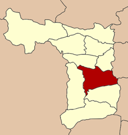 Location in Suphan Buri Province | |
| Coordinates: 14°28′3″N 100°07′01″E / 14.46750°N 100.11694°E | |
| Country |
|
| Province | Suphan Buri |
| District | Mueang Suphan Buri |
| Population (2006) | |
| • Total | 26,656 |
| Time zone | ICT (UTC+7) |

Suphan Buri (Thai pronunciation: [sù.pʰān būrīː]) is a town (thesaban mueang) in central Thailand. It covers the whole tambon Tha Philiang and parts of tambons Rua Yai and Tha Rahat, all within the Mueang Suphan Buri District. As of 2006 it had a population of 26,656. The town is 101 km north-northwest of Bangkok.
Geography
Suphan Buri lies on the Tha Chin River (known locally as the Suphan River), at an elevation of 11 metres (36 ft). The surrounding area is low-lying and flat, with rice farms covering much of the land.
Climate
Suphan Buri has a tropical wet and dry climate (Köppen climate classification Aw). Winters are quite dry and very warm. Temperatures rise until April, which is very hot with the average daily maximum at 36.9 °C (98.4 °F). The monsoon season runs from May through October, with heavy rain and somewhat cooler temperatures during the day, although nights remain warm.
| Climate data for Suphan Buri (1981–2010) | |||||||||||||
|---|---|---|---|---|---|---|---|---|---|---|---|---|---|
| Month | Jan | Feb | Mar | Apr | May | Jun | Jul | Aug | Sep | Oct | Nov | Dec | Year |
| Record high °C (°F) | 36.2 (97.2) |
39.1 (102.4) |
39.5 (103.1) |
41.2 (106.2) |
40.6 (105.1) |
39.3 (102.7) |
38.8 (101.8) |
38.2 (100.8) |
37.5 (99.5) |
36.9 (98.4) |
36.7 (98.1) |
35.5 (95.9) |
41.2 (106.2) |
| Average high °C (°F) | 32.1 (89.8) |
33.9 (93) |
35.5 (95.9) |
37.0 (98.6) |
35.7 (96.3) |
34.6 (94.3) |
34.1 (93.4) |
34.0 (93.2) |
33.4 (92.1) |
32.3 (90.1) |
31.5 (88.7) |
30.8 (87.4) |
33.7 (92.7) |
| Daily mean °C (°F) | 25.7 (78.3) |
27.4 (81.3) |
29.0 (84.2) |
30.4 (86.7) |
29.8 (85.6) |
29.2 (84.6) |
28.7 (83.7) |
28.5 (83.3) |
28.3 (82.9) |
28.0 (82.4) |
26.8 (80.2) |
25.0 (77) |
28.1 (82.6) |
| Average low °C (°F) | 20.5 (68.9) |
22.6 (72.7) |
24.2 (75.6) |
25.6 (78.1) |
25.8 (78.4) |
25.5 (77.9) |
25.0 (77) |
24.9 (76.8) |
24.8 (76.6) |
24.5 (76.1) |
22.8 (73) |
20.0 (68) |
23.8 (74.8) |
| Record low °C (°F) | 11.2 (52.2) |
14.7 (58.5) |
14.9 (58.8) |
21.3 (70.3) |
20.9 (69.6) |
22.0 (71.6) |
22.0 (71.6) |
22.0 (71.6) |
21.7 (71.1) |
18.0 (64.4) |
14.7 (58.5) |
10.4 (50.7) |
10.4 (50.7) |
| Average rainfall mm (inches) | 3.7 (0.146) |
6.9 (0.272) |
18.9 (0.744) |
49.1 (1.933) |
114.3 (4.5) |
94.4 (3.717) |
98.8 (3.89) |
118.4 (4.661) |
223.4 (8.795) |
196.7 (7.744) |
44.1 (1.736) |
6.7 (0.264) |
975.4 (38.402) |
| Average rainy days | 0.8 | 0.9 | 2.3 | 4.8 | 11.9 | 12.7 | 14.4 | 15.9 | 18.8 | 13.9 | 3.9 | 1.1 | 101.4 |
| Average relative humidity (%) | 71 | 73 | 72 | 71 | 74 | 75 | 76 | 77 | 80 | 80 | 75 | 70 | 75 |
| Mean monthly sunshine hours | 226.3 | 211.9 | 238.7 | 204.0 | 155.0 | 114.0 | 117.8 | 58.9 | 108.0 | 145.7 | 186.0 | 226.3 | 1,992.6 |
| Mean daily sunshine hours | 7.3 | 7.5 | 7.7 | 6.8 | 5.0 | 3.8 | 3.8 | 1.9 | 3.6 | 4.7 | 6.2 | 7.3 | 5.5 |
| Source #1: Thai Meteorological Department[1] | |||||||||||||
| Source #2: Office of Water Management and Hydrology, Royal Irrigation Department (sun and humidity)[2] | |||||||||||||
Culture
Suphan Buri is the place where Luk thung Superstar Pumpuang Duangjan was buried and is sometimes called the Thai Nashville, since like Nashville it is an important center of the music industry.
Transportation
Suphan Buri is at the end of a 157 kilometres (98 mi) branch line of the State Railway of Thailand's southern line. The branch meets the main line at Nong Pla Duk Junction near Ban Pong.
Route 340 passes through Suphan Buri, leading north to Chai Nat and south to Bang Bua Phong. Route 321 leads west and then south to Nakhon Pathom. Route 329 leads east to Bang Pahan. Route 3195 leads north-east to Ang Thong.
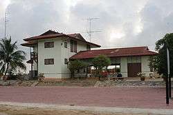
Gallery
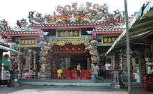 The City Pillar is housed in a Chinese temple
 Gate City Pillar Shrine, Suphan Buri
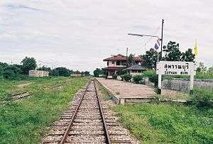 Suphan Buri Railway Station
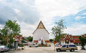 Wat Pa Le Lai
- ↑ "Climatological Data for the Period 1981–2010". Thai Meteorological Department. p. 14–15. Retrieved 4 August 2016.
- ↑ "ปริมาณการใช้น้ำของพืชอ้างอิงโดยวิธีของ Penman Monteith (Reference Crop Evapotranspiration by Penman Monteith)" (PDF) (in Thai). Office of Water Management and Hydrology, Royal Irrigation Department. p. 73. Retrieved 4 August 2016.
External links
 Suphanburi travel guide from Wikivoyage
Coordinates: 14°28′3″N 100°07′01″E / 14.46750°N 100.11694°E