Suriname River
.jpg)
The Suriname River (Dutch: Surinamerivier) is 480 km long and flows through the country Suriname. Its sources are located in the Guiana Highlands on the border between the Wilhelmina Mountains and the Eilerts de Haan Mountains (where it is known as the Gran Rio). The river flows below the reservoir along Brokopondo, Berg en Dal, the migrant communities Klaaskreek and Nieuw-Lombé, Jodensavanne, Carolina, Ornamibo and Domburg, before reaching the capital Paramaribo on the left bank and Meerzorg on the right bank. At Nieuw-Amsterdam it is joined by the Commewijne and immediately thereafter at the sandspit Braamspunt it flows into the Atlantic Ocean.
The river has several sets of rapids as well as a few dams, the largest of which is the Afobaka Dam.[1] The river's flow is interrupted by the Brokopondo Reservoir, which therefore divides the river into two sections. The upstream section runs almost entirely through the Sipaliwini district, and the downstream section runs through the Brokopondo, Para, Commewijne, Wanica and Paramaribo districts.
Navigation
For import and export, the Suriname is by far the most important river in the country. Not only do all vessels carrying bauxite, aluminum oxide and aluminum depart from Suriname via the river, nearly all vessels carrying materials vital for Suriname enter the country at Braamspunt in order to offload their cargoes in the harbours of Paramaribo (immediately south of the city centre), or the harbours of Smalkalden and Paranam – approximately 30 km from Paramaribo – which are vital for the aluminum industry. During the Second World War, the 6,000 tonne North German Lloyd cargo ship Goslar was scuttled in the Suriname in order to prevent it from falling into Allied hands. The wreck has never been removed and remains visible in the middle of the river. Coordinates: 5°49′05.32″N 55°09′32.84″W / 5.8181444°N 55.1591222°W
Bridges
In 2000, the Jules Wijdenbosch Bridge at Paramaribo was officially opened by the President, who had commissioned construction of the bridge and after whom it is named. The bridge permits access to the eastern part of the country. At Carolina, approximately 50 km South of Paramaribo, a wooden bridge crosses the river.
Recreation
Near Domburg, an artificial white sand beach has been created along the Suriname River. The adjoining strip of water has been protected with nets to allow swimming in the piranha-infested waters. As a result of this and associated recreation facilities, White Beach is a popular weekend destination.
Gallery
-
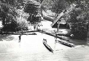
Dugout canoes at Maroon village, Suriname River, 1955
-

Suriname River at Leonsberg, Paramaribo
-
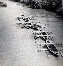
Hardwood logs transported down Suriname River in 1955
-
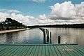
Looking downstream at White Beach
Notes
- Translated from Suriname (rivier) article on the Dutch Wikipedia, version on 24 April 2006
References
- Notes
- ↑ "Afobaka Dam: Suriname". National Geospatial-Intelligence Agency, Bethesda, MD, USA. Retrieved 2013-04-21.
- Bibliography