Para District
| Para District | |
|---|---|
|
Resorts in Para | |
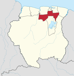 Map of Suriname showing Para district | |
| Coordinates: 5°26′N 55°13′W / 5.433°N 55.217°WCoordinates: 5°26′N 55°13′W / 5.433°N 55.217°W | |
| Country | Suriname |
| District | Para |
| Capital | Onverwacht |
| Area | |
| • Total | 5,393 km2 (2,082 sq mi) |
| Population (2012 census) | |
| • Total | 24,700 |
| • Density | 4.6/km2 (12/sq mi) |
| ISO 3166 code | SR-PR |

Para is a district of northern Suriname. Para's capital city is Onverwacht, with other towns including Paranam, Sabana and Zanderij.
Para has a population of 24,700 and an area of 5,393 km².[1]
The district is the mining and forestry centre of Suriname, with many large bauxite mining operations operating.
The ruins of the city of Jodensavanne are in Para district. Jews fleeing the Spanish Inquisition established Jodensavanne in the 17th century, but it was destroyed in 1832 by a fire. Jodensavanne was an internment camp for suspected Nazi supporters in Suriname during the Second World War.
Para is also home to a spring that supposedly has medicinal properties.
Resorts

Para is divided into 5 resorts (ressorten):
Villages
- Bigi Poika (Carib Indian)
- Carolina (Creole)
- Powakka (Arowak Indian)
Demographics
In the 2004 census, Para had 18,749 inhabitants. This rose in the 2012 census to 24,700 inhabitants, a 31.1% increase.
References
- Notes
- ↑ "Census profile at District level 2004 (in Dutch)". Stichting Algemeen Bureau voor de Statistiek in Suriname. Retrieved 2013-04-23.
- Bibliography
| Brokopondo District |  | |
|---|---|---|
| Commewijne District | ||
| Coronie District | ||
| Marowijne District | ||
| Nickerie District | ||
| Para District | ||
| Paramaribo District | ||
| Saramacca District | ||
| Sipaliwini District | ||
| Wanica District | ||