Svolvær
| Svolvær | |
|---|---|
| Town | |
|
View of the village | |
 Svolvær Location in Nordland | |
| Coordinates: 68°14′06″N 14°33′49″E / 68.23500°N 14.56361°ECoordinates: 68°14′06″N 14°33′49″E / 68.23500°N 14.56361°E | |
| Country | Norway |
| Region | Northern Norway |
| County | Nordland |
| District | Lofoten |
| Municipality | Vågan |
| Area[1] | |
| • Total | 2.33 km2 (0.90 sq mi) |
| Elevation[2] | 3 m (10 ft) |
| Population (2013)[1] | |
| • Total | 4,487 |
| • Density | 1,926/km2 (4,990/sq mi) |
| Time zone | CET (UTC+01:00) |
| • Summer (DST) | CEST (UTC+02:00) |
| Post Code | 8300 Svolvær |
| Climate | Cfc |
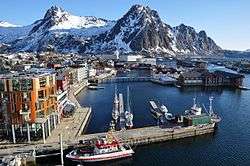
Svolvær (Norwegian pronunciation: [svɔːlvæːr] (![]() listen)) is the administrative centre of Vågan Municipality (9,200 inhabitants) in Nordland County, Norway. It is located on the island of Austvågøya in the Lofoten archipelago.
listen)) is the administrative centre of Vågan Municipality (9,200 inhabitants) in Nordland County, Norway. It is located on the island of Austvågøya in the Lofoten archipelago.
The 2.33-square-kilometre (580-acre) town has a population (2013) of 4,487. The population density is 1,926 inhabitants per square kilometre (4,990/sq mi).[1]
History


The first town formation known in North Norway, Vågar, was situated around the narrow, natural harbor near Kabelvåg, just west of Svolvær. Vågar is mentioned in the book Heimskringla, and might have been established as early as the year 800 AD.
Northern Atlantic Cod fisheries, particularly during winter months, have remained one of the most important economical foundations for the town. Other industries which have proved to be valuable resources for Vågan are fish farming (salmon), Secora and Lofotkraft.
Town status
Svolvær's historical significance as an important fishing village allowed the town to be granted town status on 1 July 1918 when the new town of Svolvær was separated from the municipality of Vågan to become its own municipality. Initially, the new municipality had 2,429 residents.
On 1 January 1964, Svolvær municipality was merged with the municipalities of Gimsøy and Vågan to form the new, larger municipality of Vågan as it is known today. Prior to the merger, Svolvær had 3,952 residents. Due to this merger, Svolvær lost its status as a "town".
Following new legislation, Svolvær was again able to declare itself a "town" in 1996.[3]
Name
The place is first mentioned in 1567 as "Suoluer", though there is some evidence of sparse settlement, likely overflowing from nearby established settlements predating the aforementioned reference. The Old Norse form of the name is assumed to be Svǫlver. The first element is probably derived from svalr which means 'cool' or 'chilly', and the last element is ver which means 'fishing village'.[4]
Economy
Other than the massive fishing industry, tourism is becoming increasingly important. Svolvær is also a major transportation hub and favourite starting point for tourists visiting the Lofoten islands. Approximately 200,000 tourists visit Svolvær each year.
A new 10-storey high combined culture scene and hotel with 160 rooms opened in March 2009. Many artists have been inspired by the unique light in Lofoten, and there are many artists and galleries in Svolvær such as the Lofoten artists house and the Stig Tobiassen gallery.
There is also a well known World War II museum in town called the Lofoten Krigsminnemuseum. Whale watching tours depart from Svolvær in late autumn and winter with a focus on Orcas (killer whales). Boat excursions to nearby Raftsundet strait and its famous branch Trollfjord is also arranged from Svolvær.
Svolvær also has a downhill skiing centre, driven solely by volunteers, Kongstind Alpinsenter. The centre has one lift, and off-piste possibilities.
Geography

Svolvær is located in the Lofoten archipelago on the southern coast of the island of Austvågøya, facing the open sea of the Vestfjorden to the south, and with mountains immediately to the north. The most famous mountain, Svolværgeita, had its first recorded climb in 1910.
Climate
Incredibly, despite the towns extremely northern location above the Arctic Circle Svolvær experiences an Oceanic climate on the border of Subpolar-Oceanic depending on the definition used. This temperature anomaly results in Svolvær having an average annual temperature warmer than cities such as Quebec City located more than 20 degrees further south. Sheltered by the mountains to the north and west, the Svolvær area has less fog and experiences somewhat higher daytime temperatures in summer than the western part of Lofoten, but the same mountains also create more orographic precipitation on rainy days.[2] Precipitation is heaviest in autumn and winter; October averages three times as much rain as does June. Svolvær has an average frost-free season of nearly 6 months.[5]
| Climate data for Svolvær (10 last years) | |||||||||||||
|---|---|---|---|---|---|---|---|---|---|---|---|---|---|
| Month | Jan | Feb | Mar | Apr | May | Jun | Jul | Aug | Sep | Oct | Nov | Dec | Year |
| Average high °C (°F) | 1.5 (34.7) |
0.6 (33.1) |
1.4 (34.5) |
4.4 (39.9) |
8.6 (47.5) |
12.2 (54) |
15.4 (59.7) |
14.4 (57.9) |
11.1 (52) |
7.3 (45.1) |
4.6 (40.3) |
2.6 (36.7) |
7.01 (44.62) |
| Daily mean °C (°F) | 0.4 (32.7) |
−0.7 (30.7) |
0.4 (32.7) |
3.3 (37.9) |
7.2 (45) |
10.8 (51.4) |
13.9 (57) |
13.2 (55.8) |
10.1 (50.2) |
6.4 (43.5) |
3.6 (38.5) |
1.6 (34.9) |
5.85 (42.53) |
| Average low °C (°F) | −0.7 (30.7) |
−1.9 (28.6) |
−0.7 (30.7) |
2.2 (36) |
5.8 (42.4) |
9.3 (48.7) |
12.4 (54.3) |
11.9 (53.4) |
9 (48) |
5.4 (41.7) |
2.5 (36.5) |
0.5 (32.9) |
4.64 (40.32) |
| Average precipitation mm (inches) | 83 (3.27) |
71 (2.8) |
58.2 (2.291) |
42.3 (1.665) |
44.4 (1.748) |
35.8 (1.409) |
44.6 (1.756) |
39.8 (1.567) |
68.2 (2.685) |
86.5 (3.406) |
72.1 (2.839) |
76.3 (3.004) |
722.2 (28.44) |
| Average precipitation days (≥ 1.0 mm) | 20 | 18 | 17 | 13 | 16 | 12 | 14 | 14 | 15 | 17 | 15 | 17 | 188 |
| Source: [6] | |||||||||||||
Transportation

Most of Svolvær is located on the main island of Austvågøya, but some parts of the town are built on small surrounding islands connected by bridges, including the Svinøy Bridge. There is a regional airport near the town, Svolvær Airport, Helle, and Svolvær is a port of call for Hurtigruten. There is a ferry connection from Svolvær to Skutvik (in Hamarøy) as well as an express boat that connects to the city of Bodø. The Lofast road (European route E10) was officially opened on 1 December 2007, giving Svolvær access to the mainland and Harstad/Narvik Airport, Evenes. There are now scheduled bus connections to Evenes (3 hr) and Narvik (4 hr 15 min). There is also a boat connection to the nearby scenic island of Skrova where there is a nice view in all directions from the hill.
Museums
Museums include the Lofoten War Museum.[7]
Twin towns
References
- 1 2 3 Statistisk sentralbyrå (1 January 2013). "Urban settlements. Population and area, by municipality.".
- 1 2 "Svolvær" (in Norwegian). yr.no. Retrieved 2012-07-21.
- ↑ Jukvam, Dag (1999). "Historisk oversikt over endringer i kommune- og fylkesinndelingen" (PDF) (in Norwegian). Statistisk sentralbyrå.
- ↑ Rygh, Oluf (1905). Norske gaardnavne: Nordlands amt (in Norwegian) (16 ed.). Kristiania, Norge: W. C. Fabritius & sønners bogtrikkeri. p. 310.
- ↑ "Svolvær statistics last 12 months". yr.no. Retrieved 2012-07-21.
- ↑ "Svolvær average conditions; base period 10 last years". Storm Weather Center. Retrieved 11 December 2009.
- ↑ Lofoten krigsminnemuseum [Lofoten War Museum]
External links
| Wikimedia Commons has media related to Svolvær. |
| Wikivoyage has a travel guide for Svolvær. |
- Pictures and information about Svolværgeita mountain
- svolvaer.net - Information about Svolvær
- Picture overlooking Svolværgeita and Svolvær
- Pictures from Svolvær and Skrova