Florești, Cluj
| Floreşti | |
|---|---|
| Commune | |
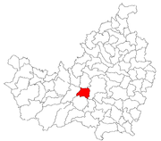
 Location in Cluj County | |
 Location on Romania map | |
| Coordinates: 46°44′51″N 23°29′27″E / 46.74750°N 23.49083°ECoordinates: 46°44′51″N 23°29′27″E / 46.74750°N 23.49083°E | |
| Country |
|
| County |
|
| Metropolitan area | Cluj-Napoca metropolitan area |
| Status | Commune |
| Villages incorporated | Floreşti, Luna de Sus, Tăuţi |
| Government | |
| • Mayor | Horia-Petru Șulea (Social Liberal Union) |
| Area | |
| • Total | 61 km2 (24 sq mi) |
| Population (2011)[1] | |
| • Total | 21,832 |
| • Density | 358/km2 (930/sq mi) |
| Time zone | EET (UTC+2) |
| • Summer (DST) | EEST (UTC+3) |
| Postal Code | 4007280 |
| Area code(s) | +40 x641 |
| Vehicle registration | FL2 |
|
1x is a digit indicating the operator: 2 for the former national operator, Romtelecom, and 3 for the other ground telephone networks 2used only on the plates of the vehicles that operate only in the city limits (like trolley buses, trams, utilitary vehicles, ATVs, etc.) | |
Floreşti (Hungarian: Szászfenes; German: Deutsch Branndorf) is a commune in Cluj County, Romania. It is composed of three villages: Floreşti, Luna de Sus (Magyarlóna) and Tăuţi (Kolozstótfalu) and is part of the Cluj-Napoca metropolitan area, being located less than 8 km west of Cluj-Napoca on DN1.
Benefiting from its proximity to Cluj-Napoca, the commune has seen a substantial development since the early 2000s, including a threefold increase in population, mainly due to several new residential developments. It was the most populous commune in Romania recorded at the 2011 census.[2]
Geography
Floreşti is located on the Someșul Mic River, in the centre of Cluj County, less than 8 km from the county capital, Cluj-Napoca, and 7 km from the commune of Gilău, on the Romanian National Road DN1.
Demographics
According to the 2011 census, the commune has 21,832 inhabitants, meaning that a 300% increase was recorded since the previous census of 2002 when 7,470 inhabitants were recorded. In terms of ethnic structure, the commune's population is composed of 78.8% Romanians, 15.1% Hungarians and 5.1% Roma.
Historical population
The historical population of the entire commune as recorded by the official censuses, and projected to the present-day administrative unit, was as follows:[1][3][4]
| Year | Total | Romanians | Hungarians | Roma |
|---|---|---|---|---|
| 1850 | 3,009 | 1,549 | 1,197 | 227 |
| 1880 | 3,655 | 1,761 | 1,546 | n/a |
| 1890 | 4,058 | 2,032 | 1,755 | n/a |
| 1900 | 4,435 | 2,260 | 1,995 | n/a |
| 1910 | 4,702 | 2,420 | 2,044 | n/a |
| 1920 | 4,956 | 2,567 | 2,251 | n/a |
| 1930 | 5,280 | 2,706 | 2,194 | 327 |
| 1941 | 6,086 | 2,612 | 3,364 | 95 |
| 1956 | 5,586 | 3,060 | 2,231 | 289 |
| 1966 | 6,012 | 3,248 | 2,399 | 369 |
| 1977 | 6,865 | 3,668 | 2,385 | 809 |
| 1992 | 6,088 | 3,439 | 2,020 | 626 |
| 2002 | 7,470 | 4,516 | 2,057 | 888 |
| 2011 | 21,832 | 17,209 | 3,299 | 1,121 |
Images
-
 The fortified Roman Catholic church
References
- 1 2 "Comunicat de presă privind rezultatele provizorii ale Recensământului Populaţiei şi Locuinţelor – 2011" (PDF). Cluj County Regional Statistics Directorate. 2012-02-02. Retrieved 2012-02-14.
- ↑ "Floreştiul, comuna cu cea mai mare populaţie din România". CityNews. 2012-11-02. Retrieved 2012-02-29.
- ↑ Varga E. Árpád: Erdély etnikai és felekezeti statisztikája (1850-1992) Retrieved 2007-05-10
- ↑ Transindex Recensamânt 2002 website Retrieved 2007-05-10
