Tåsen (station)
 | |
| Location |
Tåsen, Oslo Norway |
| Coordinates | 59°57′12″N 10°45′05″E / 59.95333°N 10.75139°ECoordinates: 59°57′12″N 10°45′05″E / 59.95333°N 10.75139°E |
| Elevation | 123.3 m (405 ft) |
| Owned by | Sporveien |
| Operated by | Sporveien T-banen |
| Line(s) | Sognsvann Line |
| Distance | 6.8 km (4.2 mi) from Stortinget |
| Connections |
Bus service: 23 Lysaker – Simensbråten 24 Fornebu – Brynseng 34 Tåsen – Simensbråten |
| Construction | |
| Structure type | At-grade |
| History | |
| Opened | 10 October 1934 |
Tåsen is a station on the Sognsvann Line (line 6) of the Oslo Metro in Oslo, Norway. The station is located between Berg and Østhorn stations and is 6.8 kilometres (4.2 mi) from Stortinget. As one of the original stations on the line, Tåsen was opened on 10 October 1934. The station was moved 150 metres (490 ft) north in the 1990s, when the line was upgraded from light rail to rapid transit standard. In 1992, a deadly accident occurred when a T1300 train collided with a plowing car ahead of the station.
The station is located near the roundabout of Tåsenkrysset, shortly after the line crosses the circumferential highway Ring 3 of Oslo on a bridge. The area around Tåsen is mainly residential, but there is also small shopping centre named "Tåsen senter" near the station.
History
Tåsen station opened 10 October 1930, when Akersbanerne had built the line from Majorstuen to Sognsvann.[1] The line was double-tracked from Majorstuen to Østhorn (then Korsvoll), and single-tracked from there to Sognsvann.[2] In 1939, the section Korsvoll—Sognsvann was upgraded to double track, and the station Korsvoll changed name to Østhorn.[1]
Tåsen was part of Holmenkolbanen's network until 1973, when the municipality of Oslo bought all the company's stocks.[3] In 1993, the stations were upgraded to metro standard, which involves a heightening and lengthening of the platforms, and installation of third rail power supply and a new signaling system.[4]
Service
Tåsen is served by line 3 on the Sognsvann Line, operated by Oslo T-banedrift on contract with Ruter. The rapid transit serves the station every 15 minutes, except in the late evening and on weekend mornings, when there is a 30-minute headway.[5] Travel time along the 6.8-kilometre (4.2 mi) portion to Stortinget in the city center is 13 minutes.[6]
The station provides correspondence to the bus lines 34, 23 and 24 in two stops near the roundabout in Rolf Wickstrøms vei.[7] The subsidiary of NOR-WAY Bussekspress, Flybussekspressen, provides a connection to Oslo Airport, Gardermoen from Tåsen.[8]
| TERMINUS | NEXT STATION ← WEST |
Tåsen | NEXT STATION EAST → |
TERMINUS | ||
|---|---|---|---|---|---|---|
| Sognsvann | Østhorn | Line 5 | Berg | Ring Line and Vestli | ||
Facilities
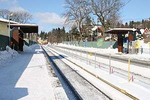
Tåsen has two platforms, each with a wooden shed.[9] The sheds are drawn by Arne Henriksen in a minimalist and standardized style with constructions of wood and steel.[10][11] The station is located in Tåsenveien, near Tåsen school,[12][13] shortly after a bridge over the circumferential highway Norwegian National Road 150.[14] There is an underpass that was constructed in the 1960s on the former side of the bridge when driving towards Sognsvann, that allows access to a small commercial center.[15] Tåsen serves the mainly the residential area Tåsen, but also Korsvoll and Nordberg.[16][17][18]
References
- Notes
- 1 2 Nilsen 1998, p. 133
- ↑ Arntzen & Hansen 2009, p. 88
- ↑ Nilsen 1998, p. 140
- ↑ "Sognsvannsbanen modernisert". Aftenposten Aften (in Norwegian). 8 January 1993. p. 8.
- ↑ "Rutetider T-banen" (PDF) (in Norwegian). Ruter. 18 August 2008. Retrieved 12 November 2010.
- ↑ "Rutetabeller T-banens linjer 2-6 og buss 1B, 1C, 1D" (PDF) (in Norwegian). Ruter. pp. 19–22. Retrieved 12 November 2010.
- ↑ "Ruter for busslinjene 20 – 28" (PDF) (in Norwegian). Ruter. Retrieved 12 November 2010.
- ↑ "Bekkestua-Røa-Rikshospitalet-Tåsen-Storo-Økern-Oslo Lufthavn" (in Norwegian). NOR-WAY Bussekspress. Retrieved 12 November 2010.
- ↑ "Hallo Oslo". Aftenposten Aften (in Norwegian). 29 October 1985. p. 2.
- ↑ Hartmann & Mangset 2001, p. 39
- ↑ "Sognsvannsbanen blir T-bane". Lokaltrafikk (in Norwegian). 15: 22–23. 1992.
- ↑ "Tåsenveien". Aftenposten Aften (in Norwegian). 10 April 2007. p. 34.
- ↑ "Informasjon om skolen" (in Norwegian). Tåsen school. Retrieved 12 November 2010.
- ↑ Google (13 November 2010). "Tåsen (station)" (Map). Google Maps. Google. Retrieved 13 November 2010.
- ↑ "Lite ras på Sognsvannsbanen". Verdens Gang (in Norwegian). 10 August 1962. p. 5.
- ↑ Tvedt, Knut Are (2007). "Tåsen". Store norske leksikon (in Norwegian). Oslo: Kunnskapsforlaget. Retrieved 12 November 2010.
- ↑ Tvedt, Knut Are (2007). "Korsvoll". Store norske leksikon (in Norwegian). Oslo: Kunnskapsforlaget. Retrieved 12 November 2010.
- ↑ Tvedt, Knut Are (2007). "Nordberg". Store norske leksikon (in Norwegian). Oslo: Kunnskapsforlaget. Retrieved 12 November 2010.
- Bibliography
- Andersen, Bjørn (1993). Holmenkollbanen: Kort historikk fra 1898 til 1993 (in Norwegian). Oslo: Lokaltrafikkhistorisk forening. ISBN 82-91223-01-7.
- Arntzen, Jon G.; Hansen, Stig A. (2009). OSLO 1925–45 (in Norwegian). Oslo: Kom forlag. ISBN 978-82-92496-80-0.
- Stang, Johan L. (1980). SOGN - en del av Oslo (in Norwegian). Tiden Norsk Forlag. ISBN 82-10-02012-9.
- Hartmann, Eivind; Mangset, Øistein (2001). Neste Stopp! : Verneplan for bygninger (in Norwegian). Oslo: Baneforlaget. ISBN 82-91448-17-5.
- Nilsen, Knut A. (1998). Nordmarkstrikken: Holmenkollbanen gjennom 100 år (in Norwegian). Oslo: Aschehoug. ISBN 82-03-22262-5.
External links
![]() Media related to Tåsen stasjon at Wikimedia Commons
Media related to Tåsen stasjon at Wikimedia Commons