Table Cape
| Table Cape Tasmania | |
|---|---|
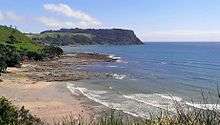 Overlooking Freestone Cove from Fossil Bluff with Table Cape in the background | |
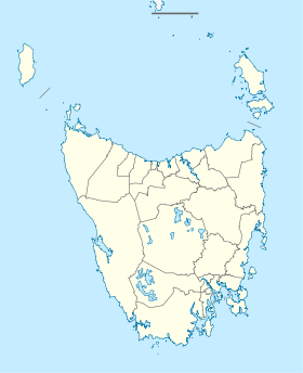 Table Cape Location of Table Cape | |
| Coordinates | 40°57′02″S 145°43′31″E / 40.95056°S 145.72528°ECoordinates: 40°57′02″S 145°43′31″E / 40.95056°S 145.72528°E |
| Population | 334 (2011)[1] |
| Postcode(s) | 7325 |
| Elevation | 180 m (591 ft) |
| Region | North West Tasmania |
Table Cape is a volcanic plug located near Wynyard on the North West of Tasmania, Australia, it is also the name of the locality which encompasses the geological feature.[1] Table Cape is a more or less circular volcanic plug with a flat top, its northern and eastern faces rise steeply from Bass Strait to a height of approximately 170 metres (560 ft) above sea level.[2] It was named by British navigator, Matthew Flinders, as he and George Bass circumnavigated Van Diemen's Land (now Tasmania) in 1798 upon the Norfolk. Flinders also progressively named the nearby Circular Head, Three Hummock and Hunter Islands.[3]
Table Cape's top and surrounding areas are composed of fertile basalt soils and are heavily cultivated,[2] the area is renowned for the annual flowering of tulips during spring and accompanying tulip festival.[4]
Landscape and conservation
Whilst the top of Table Cape and surrounding district is heavily utilised for agriculture, the steep and rocky ocean-facing embankments remain largely undisturbed from human activity and are covered in dense scrubland. The 1.26 km2 Table Cape Conservation Area (IUCN IV)[5] extends along the shoreline from Boat Harbour Beach to the Table Cape State Reserve (IUCN III)[6] before continuing along to Freestone Cove near Fossil Bluff.
Beddomeia capensis is an endangered freshwater snail known only to occur along four small streams on Table Cape, and a tributary of Big Creek near Calder. However, recent surveys have only been able to identify the species at two unnamed streams near the Table Cape Lighthouse, with the total length of occupied stream less than 80 metres (260 ft). Population declines are due to habitat degradation from agricultural land usage and competition from other introduced hydrobiid snails.[7][8]
Table Cape Lighthouse
Table Cape Lighthouse is a Tasmanian heritage-listed lighthouse situated on the 120 hectare Table Cape State Reserve. It has been open for public tours since 2010.[9][6][10][11]
After the wrecks of the Emma Prescott in 1867 and the schooner Orson in 1884, a lighthouse was commissioned to be constructed on Table Cape to aide navigation into the port of Wynyard on the Inglis River. Table Cape Lighthouse was designed by Huckson and Hutchinson of Hobart, the light apparatus was sourced from the Chance Brothers of England and was constructed by a local builder, John Luck. The project suffered from delays due to poor quality roads leading up to the construction site on Table Cape, and bricks of insufficient quality sourced from the specially-constructed kiln in the nearby town of Burnie, instead, bricks had to be imported interstate from Victoria.[12][11]
The lighthouse was first lit up on 1 August 1888, it stands about 25 metres (82 ft) high and has a diameter of 8.5 metres (28 ft) at the base. Seventeen days after the official opening, the head lighthouse keeper's 14 month old son tragically died from illness. The undertaker, who had travelled up to the lighthouse with a coffin for the child, encouraged the family to perform the burial nearby due to the appalling weather conditions at the time. The small gravesite remains to be found nearby today.[12][11]
Originally powered by oil, Table Cape Lighthouse was converted to automatic acetylene operation in 1920. In 1923, the lightkeepers were withdrawn from manning the tower, and after several years of deterioration, the nearby keepers' cottages were demolished in 1926. In 1979, mains electricity was connected and an electric beacon with standby batteries was installed, the maximum nominal range of the 100W halogen lamp is approximately 16 nautical miles (30 km; 18 mi).[12][11]
Gallery
|


See also
External links
| Wikimedia Commons has media related to Table Cape. |
References
- 1 2 Australian Bureau of Statistics (31 October 2012). "Table Cape". 2011 Census QuickStats. Retrieved 13 August 2016.
- 1 2 R. D. Gee (1971). Geological Survey Explanatory Report: Table Cape (PDF) (Report). Tasmania Department of Mines. p. 36. Retrieved 12 August 2016.
- ↑ Sprod, Dan (2006). "Companion to Tasmanian History: Exploration by Sea". utas.edu.au. Centre for Tasmanian Historical Studies. Retrieved 12 August 2016.
- ↑ Sayer, Luke (31 July 2015). "Tulip festival a bloomin' wonder for community". The Advocate. Fairfax Regional Media. Retrieved 13 August 2016.
- ↑ "Protected Planet: Table Cape Conservation Area". Protected Planet. IUCN and UNEP. Retrieved 12 August 2016.
- 1 2 "Protected Planet: Table Cape State Reserve". Protected Planet. IUCN and UNEP. Retrieved 13 August 2016.
- ↑ "Beddomeia capensis, Hydrobiid Snail (Table Cape)" (PDF). dpipwe.gov.au. Department of Primary Industries, Parks, Water and Environment, Tasmania. 2011. Retrieved 12 August 2016.
- ↑ "Threatened Species Section (2016). Beddomeia capensis (Hydrobiid Snail (Table Cape))". dpipwe.gov.au. Department of Primary Industries, Parks, Water and Environment, Tasmania. Retrieved 12 August 2016.
- ↑ "License to conduct tours of Table Cape Lighthouse" (PDF). warwyn.tas.gov.au. Waratah-Wynyard Council. May 2013. Retrieved 12 August 2016.
- ↑ Wood, Eliza (20 September 2010). "Table Cape lighthouse opens to the public". ABC News. Australian Broadcasting Corporation. Retrieved 12 August 2016.
- 1 2 3 4 Table Cape Lighthouse - Wynyard Visitor Information Centre booket. Waratah-Wynyard Council, Tasmania Parks and Wildlife Service and Australian federal government. 2010. p. 2-11.
- 1 2 3 Searle, Garry. "SeaSide Lights: Table Cape". seasidelights.com.au. Garry Searle. Retrieved 12 August 2016.